Top Qs
Timeline
Chat
Perspective
Sierrita Mountains
Landform in Pima County, Arizona From Wikipedia, the free encyclopedia

Remove ads
The Sierrita Mountains (English: "Little Mountains") is a minor mountain range about 40 mi (60 km) southwest of Tucson, in Pima County, Arizona. Historically, the area has seen extensive mining and ranching activity: several ranches, abandoned mines, and the large Sierrita Mine are located in the area. The highest point in the mountains is Keystone Peak, which rises to 6,188 feet (1,886 m).[1][2]

The Santa Cruz Valley bounds the range to the east separating it from the Santa Rita Mountains. The west margin of the range is the broad Altar Valley. To the southwest the Sierritas merge with the Cerro Colorado Mountains and the Penitas Hills. The Tumacacori Mountains of Santa Cruz County lie to the southeast.[3]
Remove ads
Gallery
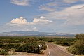 The Sierritas from Corona de Tucson.
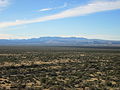 View of the Sierritas from the Santa Rita Experimental Range.


See also
References
External links
Wikiwand - on
Seamless Wikipedia browsing. On steroids.
Remove ads