Top Qs
Timeline
Chat
Perspective
Sint-Laureins
Municipality in Flemish Community, Belgium From Wikipedia, the free encyclopedia

Remove ads
Sint-Laureins (Dutch pronunciation: [sɪnt lʌuˈrɛins]; Dutch for Saint Lawrence) is a municipality located in the Flemish province of East Flanders, in Belgium. The municipality comprises the towns of Sint-Jan-in-Eremo, Sint-Laureins proper, Sint-Margriete, Waterland-Oudeman and Watervliet. In 2021, Sint-Laureins had a total population of 6,919. The total area is 74.50 km2.[2]


The Our Lady-Church in Watervliet, built in the 16th century, is called the 'Cathedral of the North'.[3]
Remove ads
Gallery
 The Boerekreek is one of several lakes in Sint-Laureins
 Water tower in Sint-Jan-in-Eremo
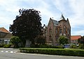 Townhall and freedom tree
 Godshuis. Nowadays hotel/restaurant

.jpg)


References
External links
Wikiwand - on
Seamless Wikipedia browsing. On steroids.
Remove ads