Top Qs
Timeline
Chat
Perspective
Smithfield, New South Wales
Suburb of Sydney, New South Wales, Australia From Wikipedia, the free encyclopedia

Remove ads
Smithfield is a suburb of Sydney, in the state of New South Wales, Australia. Smithfield is located 31 kilometres (19 mi) west of the Sydney central business district, in the local government areas of the City of Fairfield and Cumberland Council. Located in the Greater Western Sydney region, the suburb is one of the largest in Fairfield City by area. The suburb is a mix of residential, industrial, recreational, rural and commercial areas, and is mostly characterized by low-density housing.[3]

Established in 1836, Smithfield was the first major settlement of the Fairfield LGA.[4] The original 1838 summary plan of Smithfield shows the suburb laid out in a grid pattern with most of the streets having the same names as they do today.[5] The name of Smithfield is linked with the cattle markets of London and Dublin. In the 19th century, Smithfield used to be a semi-rural village, before becoming a large commercial centre in the early 20th century, in addition to featuring a significant employment centre in south-western Sydney.[6]
Located partially in the suburb, the Smithfield-Wetherill Park Industrial Estate is the largest industrial estate in the southern hemisphere and is the centre of manufacturing and distribution in greater western Sydney.[7][8] A working class area, Smithfield is also multicultural, with over 130 different nationalities and 70 different languages being spoken.[6]
Remove ads
History
Summarize
Perspective
Aboriginal people from the Cabrogal tribe, a sub-group of the Gandangara tribe, have lived in the Fairfield area for over 30,000 years. In the area that is now Smithfield, the tribe was found near the banks of Prospect Creek.[9]
Early settlement
White settlement began in the area in the early 19th century. The first significant settlement in the Fairfield area was at Smithfield due to its good soil on the Prospect Creek banks, a reliable water supply, and proximate access to Parramatta and Prospect. In June 1791 convicts John Williams and John Brown were granted 50 and 60 acres of land between Prospect Hill and present-day Hassall Street in Smithfield, and only six settlers remained there.[10] Their grants can be considered as the first land grants to appear in the Fairfield local government area and ‘the first white settlers of the future Fairfield City district’, according to historian Vance George. In 1803, homeless children were becoming a problem after convicts turned their children out into the streets. As a consequence, Governor Philip Gidley King, put aside a large area of 12,300 acres (50 km2) for a Male Orphan School. By 1836, some of this land was offered for sale by the colonial government of the time. Timber-cutting provided the income of the early settlers.[10]
Some of the best farming land was in the district to the west and southwest of the Smithfield area. Smithfield comprised the original grant of 2,118 acres (9 km2) given to James Chisholm, and the area was initially called 'Chisholm's Bush'.[11] John Ryan Brenan (1798–1868), an attorney who was appointed Police Magistrate in 1836, bought 1,650 acres (7 km2) here. After subdividing the estate, Brennan initially titled his land 'Donnybrook' (after the Irish market town of the same name). Early settlers, many being Irish Catholics, were attracted to Smithfield by its good soil, dependable water supply and easy access to the Colony's established towns. Brennan Street is where the cattle sale yards were originally located. Sale yards opened in 1841, but the project to establish a village around the yards failed.[12][9] English farmers mostly settled on lands along the Sherwood side of the Prospect Creek and a small colony of Italians assembled together just north of the village, and for many years the whole region was renowned for its beautiful vineyards.[11]
Colonial expansion

In 1841, Victoria Street was a broad boulevard that ran through the wool market in the Queen's Square. The 'Smithfield Market and fair Green' was a semi-circular area that featured 42 stalls of various sizes for the sale of thousands of livestock, in addition to cheese and butter. In 1842, Brennan changed the name from Donnybrook to 'Smithfield Market, Town of Prospect' as he assumed the area would extend to the proximate village at Prospect Hill. In July 1842, Smithfield Market was pompously described as "...without exception the largest and best constructed in the world". The suburb's grid pattern of streets in the older areas were influenced by a marketplace near London.[9]
According to historian John Wilkinson, the name of the project was swiftly diminished to Smithfield by common practice in the hope that cattle sales will be held there. Although Smithfield was more like a 'tent city' than a flourishing urban center (especially after the markets closed down in 1845),[9] it still became a thriving commercial centre. In the subdivision, Brenan offered an extra adjoining allotment to any buyer who built a cottage with a brick chimney and enclosed the property with a fence. The public school opened in 1850 and by the 1880s Smithfield was well provided with churches, many of which still remain today as important relics of Smithfield's rich local heritage. The first recorded religious service in Smithfield was held by the Baptists in the 1840s, as many Baptists bought lands in the township to escape ridicule of their adult baptism in Cooks River. Their settlement in Smithfield was described as "carving out a new town in the wild bush". Although Smithfield had a large Irish Catholic population, the Catholic Church struggled to obtain acknowledgment by the early colonial power.[9]
A national school building was established in January 1851, and it still is one of the state's oldest public school buildings. In the 1860s, Smithfield was mostly populated by vine growers, gardeners, wood timber cutters, orchards and tanneries. In 1866, Smithfield was a postal village lying on fertile lands in the Parish of Saint Luke and had a population of 500 people in a land that was reasonably woody. The village featured one Church of England (the first service in the wider area) and a Baptist chapel, in addition to two hotels called the ‘Lucky Bushman’ and ‘The Smithfield Inn’. Residents in the area were mostly farmers, fruit growers and workers at hide-tanning factories.[9]
In 1871, the township had 264 residents. In the late 1880s, Smithfield was a prominent town in the areas, and it expanded in population due to the significant construction project of the Prospect reservoir. A slab cottage built in 1880 in what was the Queen's Square site (now Chifley Street) still remains in the area, in addition to being listed on the Fairfield City Council Heritage List since 1997.[13] In 1887, J.a.M. Mclean established a vineyard called 'Kaluna' on The Horsley Drive until the land was subdivided in 1959.[a][9]
Urban development

In 1888, an agreement was accomplished between Smithfield and Fairfield to become a merged municipal council; The ‘Smithfield and Fairfield Municipality’, which had a population of about 1200 and included 250 houses, before changing to 'Fairfield' in 1920, reflecting the growth of the Fairfield CBD. Although Fairfield's commercial area was growing during the 1890s to 1910s, Smithfield was still the district’s largest commercial and religious centre, which included various stores, shops and churches. A literary institute Hall was built in the early 1900s, and in 1913 it became the first ever movie theater in the district. Chifley Street used to be 'Water Street' until the 1950s. There was also George Street, which ran through what is now Rosford Street Reserve, and Dublin Street traversed north through the area that was the reserve, adjoining Gipps Road, up until the early 1980s when the Reserve was established.[9]
In a 1918 news article by The Cumberland Argus and Fruitgrowers' Advocate, Smithfield was described as "one of the oldest villages in the greater Parramatta district" and lagging behind Fairfield CBD.[11] In 1924, the Sydney and Suburban Blue Metal Quarries constructed the Widemere Quarry Line to connect the Booth mine at Prospect Hill with Fairfield railway station. The railway passed through what is now The Horsley Drive (then Smithfield Street) and Dublin Street, before closing in 1945. At this time, German, Italian, Maltese and Chinese immigration to the area started to grow. The Fairfield Motor Cycle Club formed in 1935 and it was provided a circuit track in Dublin Street, Smithfield, before closing down in the 1960s.[9]
In the 1940s, the areas near Prospect Creek still had many dairies, vineyards and market gardens, including woodcutting industries as timber was still abundant, and Smithfield was still neither a rural township, nor a remarkably urban area. In the 1940s and 1950s, garbage dumps and sewerage outlets were installed in the suburb, and the area that is now Brenan Park was a landfill up until 1980, before becoming the aforementioned urban park. In 1970s, politician Janice Crosio stated she partook in local politics because she could not stand seeing Smithfield underwater during floods. In the early 1970s, millions of dollars were spent on demolishing older structures and constructing modern offices, in addition to establishing a supermarket in Smithfield Mall.[9] In February 1990, the suburb was affected by the worst flooding in its history where six houses were inundated above the floor level.[15] In February 2011, the suburb made national headlines when a light aircraft crash landed in Brenan Street, where it caused power loss to 7000 businesses and homes after the plane knocked down multiple power lines.[16]
Remove ads
Transport
The Horsley Drive and Cumberland Highway are the major road that run through Smithfield. Other major roads include Polding Street, Brennan Street and Victoria Street, with the latter featuring factories.
Bus services are provided by Transit Systems Sydney. The closest train stations are Fairfield train station and Yennora railway station, on the Inner West & Leppington Line and Cumberland Line. Transit Systems Sydney buses 806, 808, 812, 813, 814 and 817, which go through the suburb, link to Fairfield's train station, with 806 also linking to Parramatta railway station and Liverpool railway station.
There is a cycle way called Prospect Creek cycleway that runs through the suburb, which is part of the Western Sydney Regional Park recreational route.[17]
Remove ads
Culture
Summarize
Perspective
Smithfield features an art gallery, museum and an RSL club. Smithfield was the location for the 7mate show Housos, being one of the many locations for that TV show. Smithfield Cemetery, established in the 19th century, is situated in the western parts of the suburb, and is currently managed by the Syriac Orthodox Church.
Places of worship
In the 1880s, the suburb constructed the first Church of England building, the St James Church (1867), a Methodist church (1886) and St Gertrude’s Catholic Church (1884). During the 1880s, with four major churches constructed, Smithfield was the leading religious area in the district.[9] Today, these places of worship are found in the suburb:
- Smithfield Baptist Church is on the corner of The Horsley Drive and O’Connel Street
- St James Anglican church is on the corner of The Horsley Drive and Justin Street
- St Benedicts Catholic Church is located in Justin Street
- Smithfield Uniting Church is on The Horsley Drive
- Minh Giac Temple, a Vietnamese Buddhist temple on the Horsley Drive
- St Mary's Church, an Assyrian church is located in Polding Street
- Smithfield Mosque, (known as the Australian Bosnian Islamic Society Gazi Husrevbeg) is located in Bourke Street.[18]
Commercial area
Summarize
Perspective

The commercial area is centred on The Horsley Drive, which is the main street in Smithfield, the most significant east-west road in the region that runs from Carramar and Wetherill Park. The roadway is ornamented by several curtain figs. The suburb's mains street features health services, a gymnasium, beauty and specialty shops, commercial services, multicultural restaurants such as Italian, Middle Eastern and Chinese among others. A prominent pub on The Horsley Drive and Cumberland Highway, with an entryway from Victoria Street as well, called the Smithfield Tavern features a restaurant, a TAB, adult entertainment sessions and concert parties. Also on the road is the smaller Smithfield Commercial Centre, an arcade-like building that features businesses and commercial services therein. There is also a small commercial strip in Dublin Street, between Brenan and Jane Streets.[15]
The main road features Smithfield Square, which has been in major redevelopment as of 2025 and occupies the largest land holding in Smithfield CBD. Upon completion, the square will have a net lettable area of 5,500 square metres (59,000 square feet), converting the two-level retail centre into a shopping mall for recreation and services.[19] Lying on the west side of Cumberland Highway and featuring another entry point from Victoria Street, the square will feature a childcare centre, swim school, gym and a medical centre, supported by a range of specialty retail stores. Its 200+ parking space is shared with Smithfield Tavern. The square contained a Coles supermarket in the second level, before it closed in late 2022 as part of the ongoing refurbishment.[20]
There is a large industrial area in Smithfield with a number of factories and warehouses. The industrial estate in suburb is the largest in the southern hemisphere and is one of the primary centres for manufacturing and distribution in Greater Western Sydney.
Remove ads
Recreational areas

Brenan Park is a large recreational area, and one of the most prominent in Fairfield City, which features sports grounds, children's playgrounds and picnic areas.[21]
Rosford Street Reserve is a parkland in the northern skirts of the suburb which features a large sports grounds and an urban forest that lies along Prospect Creek. The Reserve adjoins Long Street Park to the east and Gipps Road Park to the northwest, the former being in Cumberland Council section of Smithfield and the latter being in Greystanes.
Other large parks in the suburb include Smithfield Park on The Horsley Drive (which is the oldest park in Smithfield and features a large soccer field) and Prospect View Park, which also features a large sports field. Minor parks include Beaumont Park, Shamrock Park, Clarrie Atkins Park, Tarrawarra Reserve, Kaluna Reserve and Vineyard Reserve.
Remove ads
Geography
Summarize
Perspective

The suburb incorporates Smithfield West, which is mostly a residential locality in the western portion of Smithfield, in addition to being an unofficial designation for the region westwards from Dublin Street to the boundary of Wetherill Park.[2]
Smithfield is within the plant community called the Cumberland Plain Woodland and contains a small patch of the threatened Cooks River/Castlereagh Ironbark Forest (within Smithfield Cemetery), which feature Eucalyptus fibrosa, Melaleuca decora and Eucalyptus moluccana as the dominant canopy species.[22] As urban development advanced in the area, many of the gullies and waterways that formerly drained runoff into Prospect Creek were replaced by stormwater pipes (one being the "Rosford Channel", that starts from Victoria Street).[15]
Somewhat hilly, Smithfield's altitude ranges from 21 to 48 m (69 to 157 ft) above sea level. The suburb is situated on the Cumberland Plain biogeographic region and it predominantly lies on the Middle Triassic Bringelly Shale (with the areas near Prospect Creek being on Cenozoic alluvial deposits).[23]
Climate
Smithfield has a humid subtropical climate (Köppen climate classification: Cfa) with warm to hot summers and mild to cool winters with sporadic rainfall throughout the year. It is usually a few degrees warmer than Sydney CBD on summer days and a few degrees cooler on winter nights. There could be a temperature differential of 5–10 °C (9–18 °F) in summer due to sea breezes in the coast that do not generally penetrate inland. The suburb receives less annual rain than Sydney CBD by about 300 mm (11.81 in). Late winter and early spring receive the least rainfall, whilst late summer and autumn receive more rain.[24]
Remove ads
Education
There are local primary schools including Smithfield Public School and Smithfield West Public School. Although there are no local high schools, residents living in the western vicinity of Smithfield are in the area for Westfields Sports High School, and Fairfield High School for those living in the southeastern outskirts of the suburb.
Politics
Smithfield is governed at the local government level by Fairfield City Council, with Frank Carbone (Independent) as Mayor. At the state level, Hugh McDermott (Labor) is the state member for Prospect. At the federal level, Chris Bowen and Jason Clare (both Labor) are Federal MPs for the seats of McMahon and Blaxland respectively.
Smithfield was an electoral district of the Legislative Assembly in the Australian state of New South Wales from 1988 to 2015, where it was largely replaced by, and centred on, Prospect.[29]
Remove ads
Demographics
Summarize
Perspective
According to the 2021 Australian Bureau of Statistics Census of Population, there were 13,160 persons usually resident in Smithfield. The median age of people in Smithfield was 38 years. Smithfield had an unemployment rate of 8.9%.[1]
- Ethnic diversity
The most common ancestries in Smithfield were Australian (12.7%), Assyrian (11.4%), English (10.0%), Vietnamese (9.2%) and Iraqi (9.0%). 31.2% of people only spoke English at home. Other languages spoken at home included Arabic (15.3%), Assyrian Neo-Aramaic (10.5%), Vietnamese (9.6%), Chaldean Neo-Aramaic (5.7%) and Spanish (3.2%).[1] Combining the Assyrian and Chaldean Aramaic varieties, Neo-Aramaic will be the most common language other than English, at 16.2%.
- Country of birth
Of the people in Smithfield, 42.4% of them were born in Australia. 13.7% of people had both parents born in Australia and 72.9% of people had both parents born overseas. The other common countries of birth were Iraq (18.1%), Vietnam (6.9%), Syria (4.8%), Italy (2.3%) and Lebanon (2.2%).[1]
- Religion
Almost three in four residents (68.4%) practice Christianity. The most common responses for religion were Catholic (38.4%), No Religion (10.6%), Islam (9.4%), Buddhism (8.0%) and Assyrian Apostolic (6.8%).[1]
- Housing
Separate housing dominates the area, comprising 77.3% of total occupied private dwellings, 10.7% were semi-detached, row or terrace houses, townhouses etc., 10.2% were flat or apartments and 1.5% were other dwellings. 27.3% of the dwellings were owned and 26.4% were owned with a mortgage, and 43.0% were rented. 7.1% had 1 bedroom, 15.2% had 2 bedrooms, 43.7% had 3 bedrooms and 32.0% had 4 or more bedrooms. The average number of bedrooms per occupied private dwelling was 3.1. 51.2% were couple families with children, 24.1% were couple families without children and 22.4% were one parent families, 15.9% of single parents were male and 84.8% were female.[1]
Notable people
Gallery
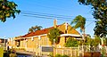 St Mary's Church, an Assyrian place of worship
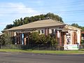 Smithfield Gallery
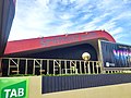 Smithfield Tavern
 The Horsley Drive, Smithfield's main street


References
Notes
Wikiwand - on
Seamless Wikipedia browsing. On steroids.
Remove ads