Top Qs
Timeline
Chat
Perspective
Snowpatch Spire
Mountain in British Columbia, Canada From Wikipedia, the free encyclopedia

Remove ads
Snowpatch Spire is a mountain peak in British Columbia, Canada. With its first ascent in 1940, it was the last of the Bugaboo Spires to be climbed.[2] It is located southwest of the Conrad Kain hut, between Bugaboo, Vowell and Crescent Glaciers, at the south end of Bugaboo Provincial Park.[7] The mountain's toponym was officially adopted October 29, 1962, by the Geographical Names Board of Canada.[3]


Remove ads
Climate
Based on the Köppen climate classification, Snowpatch Spire is located in a subarctic climate zone with cold, snowy winters, and mild summers.[8] Winter temperatures can drop below −20 °C with wind chill factors below −30 °C.
Routes
Climbing routes on Snowpatch Spire:[9]
- Wildflowers - class 5.9
- Kraus-McCarthy - class 5.9
- Sunshine - class 5.11
- Surf's Up (aka Southwest Ridge) - class 5.9
- Southeast Corner (aka Snowpatch Route) - class 5.8
Gallery
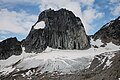 Northeast aspect
 Snowpatch Spire seen from Bugaboo Spire
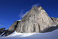
 Howser Spire (upper left), Snowpatch Spire (left of center), Bugaboo Spire (upper right), Eastpost Spire (lower right). Camera pointed west.
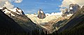 Anniversary Peak (left), Hound's Tooth/Marmolata Spire (centered) in Bugaboo Glacier, and Snowpatch Spire (right). East aspect as viewed from Bugaboo Lodge.


References
External links
Wikiwand - on
Seamless Wikipedia browsing. On steroids.
Remove ads