Top Qs
Timeline
Chat
Perspective
Spaarnwoude
Village in North Holland, Netherlands From Wikipedia, the free encyclopedia

Remove ads
Spaarnwoude is a village in the Dutch province of North Holland. It is a part of the municipality of Haarlemmermeer and lies about 5 km (3.1 mi) northeast of Haarlem.


Remove ads
Overview
The village was first mentioned in the first half of the 11th century as Spirnerewalt, and means "forest along the Spaarne river".[3]
The former Dutch Reformed church dates from 1764, but has a tower from the 13th century. It was decommissioned in 1880, but is still used for cultural activities.[4]
North of Spaarnwoude lies the Spaarnwoude recreation area, which is located in the municipalities of Velsen and Haarlemmermeer.
There is a railway station, Haarlem Spaarnwoude, which lies southwest of the village.[5] An IKEA shop is nearby, on the north side. To the east of IKEA is the Veerplas.
Spaarnwoude was home to 443 people in 1840.[4] It was a separate municipality until 1857, when it merged with Haarlemmerliede.[6] The resulting municipality of Haarlemmerliede en Spaarnwoude was later merged with Haarlemmermeer, in 2019.[7]
Remove ads
Gallery
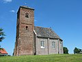 The church of Spaarnwoude
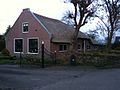 Farm in Spaarnwoude


See also
References
External links
Wikiwand - on
Seamless Wikipedia browsing. On steroids.
Remove ads