Top Qs
Timeline
Chat
Perspective
Strait of Bonifacio
Strait in Mediterranean Sea From Wikipedia, the free encyclopedia

Remove ads
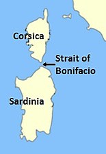
The Strait of Bonifacio (French: Bouches de Bonifacio; Italian: Bocche di Bonifacio; Corsican: Bucchi di Bunifaziu; Gallurese: Bocchi di Bunifaciu; Sardinian: Buccas de Bonifatziu; Ligurian: Bocche de Bunifazziu; Latin: Fretum Gallicum, Fretum Taphros) is the strait which connects the islands of Corsica and Sardinia. It is named after the Corsican town Bonifacio, the most southerly on the island, which was in turn named after Boniface I, Margrave of Tuscany, who founded a citadel in its location circa 828AD.[1]
.JPG)


Remove ads
Location
At its narrowest point, the strait is 11 km (6.8 mi) wide[2] and divides the Tyrrhenian Sea from the western Mediterranean Sea. Its maximum depth is 100 metres (330 ft).[3] The Sea of Sardinia and the Gulf of Asinara are located to the west of the Strait.[4]
The strait is notorious among sailors for its weather, currents, shoals, and other obstacles. The strait, while relatively narrow, has no bridge crossing and relies on ferry services.[4]
Remove ads
Disasters
The most famous disaster in the Strait of Bonifacio was that of the French frigate Sémillante on February 15, 1855. Sémillante had left the port of Toulon the day before on her way into the Black Sea to supply the Crimean War with troops. A storm caused her to hit a reef; the ship sank and none of the 750 soldiers on board survived.[4]
After a tanker disaster in 1993, the passage through the Strait of Bonifacio has been prohibited for French and Italian flag ships with dangerous goods. Passage for ships with dangerous goods sailing under other flags is strongly discouraged and subject to mandatory piloting.[5][6]
Remove ads
Gallery
- Strait of Bonifacio
 Location of the Strait.
 The Strait as seen from Santa Teresa di Gallura in Sardinia; Corsica is in the background.
 The Strait as seen from the northernmost tip of Sardinia; the southern coast of Corsica is barely visible.
 The Strait as seen from the Corsican coast.
 The Strait as seen from the air.


See also
References
External links
Wikiwand - on
Seamless Wikipedia browsing. On steroids.
Remove ads