Top Qs
Timeline
Chat
Perspective
Sufla
Palestinian village, depopulated in 1948 From Wikipedia, the free encyclopedia

Remove ads
Sufla (Arabic: سفلى) was a Palestinian Arab village in the Jerusalem Subdistrict. It was depopulated during the 1948 Arab–Israeli War on October 19, 1948, by the Sixth Battalion of the Harel Brigade under Operation Ha-Har. It was located 18.5 km west of Jerusalem.
.jpg)
.jpg)
.jpg)
.jpg)

Remove ads
History
Summarize
Perspective
Remains from the Crusader era have been found here.[5]
Ottoman era
In 1838, it was noted as a Muslim village, es-Sifala, in the el-Arkub District, south west of Jerusalem.[6]
In 1863 Victor Guérin noted a large grotto, partly filled with water. According to Guérin, Sufla was "reduced to a dozen houses."[7]
An official Ottoman village list of about 1870 showed that safle had a total of 8 houses and a population of 18, though the population count included men only.[8][9]
In 1883, the PEF's Survey of Western Palestine (SWP) described Es Sifleh as "a small village on a narrow ridge, which falls rapidly from Beit 'Atab. On the south-east is a fine spring ('Ain Sitti Hasna) coming out of a cleft in the rocks."[10]
British Mandate era
In the 1922 census of Palestine conducted by the British Mandate authorities, Sufleh had a population of 46 inhabitants, all Muslims,[11] increasing slightly in the 1931 census to a population of 49 inhabitants, in 10 houses.[12]
In the 1945 statistics, the village had a population of 60 Muslims,[4] with a total of 2,061 dunams of land according to an official land and population survey.[3] Of the land, 400 dunams were for cereals,[13] while 3 dunams were built-up (urban) land.[14]
A shrine was located in the village dedicated to a local sage called al-Shaykh Mu'annis.[5]
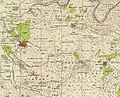 Sufla, Mandate survey, 1:20,000
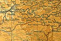 Sufla, 1945, 1:20,000


1948 and aftermath
The village was depopulated in October, 1948, by the Harel Brigade under Operation Ha-Har, as were the villages of Dayr Aban, Bayt 'Itab, Beit Jimal, Bayt Nattif, Az-Zakariyya, and Al-Burayj.[15] Following the war, the area was incorporated into the State of Israel, although the land of Sufla was left undeveloped.[5]
In 1992, the village site was described as: "Stone rubble from houses is scattered throughout the site, which has become an open grazing area. Cave-like structures, formerly used as dwellings, also are present, and cactuses grow among the ruins and rubble. The village cemetery lies to the east of the site, and almond and olive groves cover the areas to the west and north."[5]
Remove ads
References
Bibliography
External links
Wikiwand - on
Seamless Wikipedia browsing. On steroids.
Remove ads