Top Qs
Timeline
Chat
Perspective
Sumbawa Regency
Regency in West Nusa Tenggara, Indonesia From Wikipedia, the free encyclopedia
Remove ads
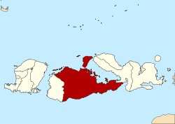
Sumbawa Regency (Indonesian: Kabupaten Sumbawa) is a Regency (Kabupaten) of the Indonesian Province of West Nusa Tenggara. It is located on the island of Sumbawa and covers an area of 6,643.99 km2, following the separation on 18 December 2003 of what were until then its westernmost five districts to form the newly created West Sumbawa Regency. It includes the substantial island of Moyo, lying off the north coast of Sumbawa. The population of the Regency at the 2010 Census was 415,789,[2] which rose at the 2020 Census to 509,753;[3] the official estimate as at mid 2024 was 527,715 (comprising 263,993 males and 263,722 females).[1] The capital is the town of Sumbawa Besar on the north coast of Sumbawa Island.
Remove ads
Administrative districts
Summarize
Perspective
Sumbawa Regency is divided into twenty-four administrative districts (kecamatan), listed below with their areas and their populations at the 2010 Census[2] and the 2020 Census,[3] together with the official estimates as at mid 2024.[1] The table also includes the locations of the district administrative centres, the number of administrative villages and subdistricts in each district (totaling 157 rural villages (desa) and 8 urban subdistricts (kelurahan), the latter all in Sumbawa town District), and its postal code(s).
Note: (a) the five southern districts of Lunyuk, Orong Telu, Ropang, Lenangguar and Lantung are comparatively less densely populated; they cover a combined area of 2,095.96 km2 (31.5% of the regency) with 48,605 inhabitants (just 9.2% of the regency) in mid 2024.
(b) including Panjang Island off the northwest coast of Sumbawa. (c) including Saringi Island and 4 smaller islands off the northwest coast of Sumbawa.
(d) The 8 villages comprising Sumbawa (town) District are all classed as urban kelurahan (Brang Bara, Brang Biji, Bugis, Lempeh, Pekat, Samapuin, Seketeng and Uma Sima); the other 157 villages in the regency are all classed as rural desa.
(e) Labuhan Badas District comprises the substantial (in area) but sparsely populated island of Pulau Moyo (administratively, Labuhan Aji and Sebotok desa), covering 345 km2 with about 4,200 inhabitants; it also includes the smaller Pulau Medang (with even smaller Bajo Medang) to its west, and the small Pulau Sakonci to its northeast off the coast of the Sanggar Peninsula, together with an area of 66.46 km2 on mainland Sumbawa situated to the west of Sumbawa Besar (town), this mainland area containing most (29,245 people in 2023) of the district's population.
(f) Note that the three districts with "Moyo" in their names do not include any part of Moyo Island, but are situated to its south on Sumbawa Island itself and on other small offshore islands.
(g) the last-named five districts constitute the eastern extension of the regency, with a combined area of 1,828.78 km2 and 109,247 inhabitants in mid 2024, based on the town of Plampang with 5,359 inhabitants in 2023.
Remove ads
Sister Districts
![]() Kulim, Malaysia
Kulim, Malaysia
References
External links
Wikiwand - on
Seamless Wikipedia browsing. On steroids.
Remove ads


