Top Qs
Timeline
Chat
Perspective
Tadiandamol
Mountain in Karnataka, India From Wikipedia, the free encyclopedia

Remove ads
Tadiandamol or Thadiyandamol is the highest mountain of Madikeri taluk Kodagu district, Karnataka, India. It is the first highest peak in Karnataka, after Mullayyanagiri & Kudremukha.[1] It is located Western Ghats range, and reaches an elevation of 1,748 m. The mountain has patches of shola forests in the valleys.


The Nalaknad (also known as Nalnad – meaning 4 villages) palace at the foothills is an important historical landmark.
It is a place of interest for trekkers and naturalists. The climb to the top and back can be completed as a day hike(within 5hrs) and the entry is closed at 5:00 pm; camping is banned since December 2016.The best time to visit the peak is July-end to September(after monsoon) as greenery is observed well in these months.
Remove ads
Etymology
The name Tadiandamol literally means largest base (thadi = broad, large, huge; anda = belonging to (possessive) in Kodava; mol = hill, base, peak). It loosely means Tallest Mount,[2] and the name also could translate as Broad Hill.[3]
Gallery
 View from Tadiandamol Peak during august end
 View from Tadiandamol Peak
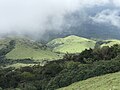 Greenery seen from Tadiandamol Peak
 View From Second Topmost hill during Tadiandamol trekking
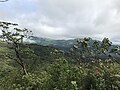 checkpost and starting point of Tadiandamol Trek
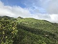 checkpost and starting point of Tadiandamol Trek pic 2
 Tadiandamol Trekking starting point view from Resort
 Tadiandamol Trek View from 2nd viewpoint


See also
References
External links
Wikiwand - on
Seamless Wikipedia browsing. On steroids.
Remove ads