Top Qs
Timeline
Chat
Perspective
Taihang Mountains
Mountain range in northern China From Wikipedia, the free encyclopedia

Remove ads
The Taihang Mountains (Chinese: 太行山; pinyin: Tàiháng Shān) are a Chinese mountain range running down the eastern edge of the Loess Plateau in Shanxi, Henan and Hebei provinces. The range extends over 400 kilometers (250 mi)[1] from north to south and has an average elevation of 1,500 to 2,000 m (4,900 to 6,600 ft); its principal peak is Mount Xiaowutai.[1] The Taihang's eastern peak is Mount Cangyan in Hebei; Baishi Mountain forms its northern tip.[citation needed]
.jpg)


Remove ads
Event
- 185 rebels of the Yellow Turban are defeated by the imperial army, but only two months later, the rebellion breaks out again. It spreads to the Taihang Mountains on the western border of Hebei Province.
Background
The Taihang Mountains were formed during the Jurassic. Brown forest and Cinnamon soils are found here.[2]
The name of Shanxi Province, meaning "west of the mountains", derives from its location west of the Taihang Mountains.[3] The name of Shandong Province (east of the mountains) originally applied to the area east of the Xiao Mountains, but by the Tang dynasty it refers to the area east of the Taihang Mountains; this entity evolved into the modern-day Shandong Province, though the actual border of the province has moved considerably to the east.[4]
The Hai River system runs through the Taihang Mountains.[2] The Red Flag Canal is located on the south edge of the Taihang Mountains.
The Shijiazhuang–Taiyuan high-speed railway crosses under the Taihang Mountains via the Taihang Tunnel, the third longest rail tunnel in China.
Many references to this range in “Fanshen” by William Hinton, with their significance in the Chinese Socialist revolution.[citation needed]
Remove ads
Gallery
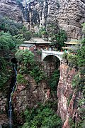
 Taihang in Hebei
 Taihang in Changping, Beijing
 Scenery of Taihang Mountain

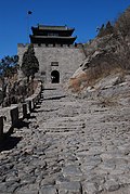
 Mount Cangyan
 Mount Qibugou


.jpg)


See also
- The Foolish Old Man Removes the Mountains (Chinese: 愚公移山), One of the two mountains mentioned in the ancient Chinese myth, the other is Mount Wangwu.
- Taihangshan Gorge of China
- Guoliang Tunnel
References
External links
Wikiwand - on
Seamless Wikipedia browsing. On steroids.
Remove ads