Top Qs
Timeline
Chat
Perspective
Te Ārai
Place in Auckland Region, New Zealand From Wikipedia, the free encyclopedia
Remove ads
Te Ārai is a small community on the east coast of the North Island of New Zealand, near the northern end of the Auckland Region (specifically within the former Rodney District). Mangawhai lies to the north, and Tomarata to the south. The name comes from Tāhuhunui-o-te-rangi, captain of the Moekākara waka, who landed here and set up a temporary shelter (arai). Tāhuhunui-o-te-rangi was later buried at Te Ārai.[1]
Remove ads
Geography
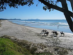
Te Ārai Beach is a sandy bottom beach and is a very popular surfing destination, rated one of the best surf locations in the Auckland region.[citation needed]
Te Ārai Beach is the exact antipode of Gibraltar.[citation needed]
Among the bird species found here is the critically endangered New Zealand fairy tern, of which only 11 breeding pairs are left in the world.[citation needed] Auckland Council manages Te Ārai Regional Park.[2]
Remove ads
History
The Arai Road District was formed on 20 February 1868, it governed Te Arai until c.1886 when it was dissolved.[3]
Economy
Tourism and farming are the predominant activities in the area.[citation needed]
References
External links
Wikiwand - on
Seamless Wikipedia browsing. On steroids.
Remove ads


