Top Qs
Timeline
Chat
Perspective
Texhomex
Texas-New Mexico-Oklahoma border tripoint From Wikipedia, the free encyclopedia
Remove ads
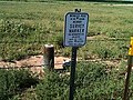
Texhomex is a marker showing the tri-point of Oklahoma, Texas and New Mexico. The marker is off U.S. Highway 56 about two miles east on Texas State Line Road at the corner of Oklahoma State Line Road, and is at an elevation of 4712 feet.[1] There are no signs on Highway 56 in either direction.
The tri-state marker is typically covered by soil, but a nearby concrete pillar marker can be seen across the fence a few feet away. A witness post and sign are a few inches from the underground marker.[2][3][4][5][6]
Remove ads
Other nearby geographic points
The northwest corner of the Texas panhandle is located 2.2 miles west of this point, although it should theoretically be at the same spot. The great distance is due to surveying errors in 1859 by the surveyor John H. Clark. The joint congressional resolution in 1911 declared the line surveyed by Clark to be the actual boundary line between Texas and New Mexico. The northwest corner of the Texas panhandle had been previously marked[7] but the marker was either removed or buried when the highway was widened in 2016.[8]
The marker for the Cimarron Meridian initial point is located approximately 350 feet north of the Texhomex corner, and is marked by a concrete pillar and a sign.[9]
 Marker location
 New Mexico top right, Oklahoma bottom right, Texas on the left.

.jpg)
Remove ads
See also
- List of tripoints of U.S. states
- Four Corners Monument: monument on the Arizona-Colorado-New Mexico-Utah border
- International Boundary Marker: monument on the Louisiana-Texas border
- OKKAMO Tri-State Marker: monument on the Arkansas-Missouri-Oklahoma tripoint
- Preston Monument: monument on the Colorado-New Mexico-Oklahoma tripoint
References
External links
Wikiwand - on
Seamless Wikipedia browsing. On steroids.
Remove ads