Top Qs
Timeline
Chat
Perspective
Toomsuba, Mississippi
Census-designated place in Mississippi, United States From Wikipedia, the free encyclopedia
Remove ads
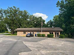
Toomsuba is a census-designated place (CDP) and unincorporated community in Lauderdale County, Mississippi, United States.[2] Its population was 778 as of the 2020 census.[3] Its ZIP code is 39364.[4]
The community is named after Toomsuba Creek.[5]
Remove ads
Geography
Toomsuba is in eastern Lauderdale County, 13 miles (21 km) east of Meridian, the county seat. U.S. Routes 80 and 11 pass through the community as its main street. Interstate Highways 20 and 59 run along the southern edge of the community, with access from Exit 165 (Will Garrett Road). I-20 and I-59 lead west to Meridian and northeast 77 miles (124 km) to Tuscaloosa, Alabama, while U.S. Route 11 and 80 lead west to Meridian and east 9 miles (14 km) to their split near Cuba, Alabama.
According to the U.S. Census Bureau, the Toomsuba CDP has a total area of 5.0 square miles (13.0 km2), of which 4.7 square miles (12.1 km2) are land and 0.3 square miles (0.8 km2), or 6.27%, are land.[6] In addition to the Toomsuba town center at the crossroads of US 11/80 with Will Garrett Road and Lauderdale–Toomsuba Road, the CDP contains residential development around Bailey Lake, a reservoir just west of the town center.
Remove ads
Demographics
As of the 2020 United States census, there were 778 people, 300 households, and 194 families residing in the CDP.
Remove ads
Notable people
- Norman Robinson, former New Orleans journalist[11]
- Jack Spinks, former National Football League fullback and partial namesake of Casem-Spinks Stadium, the home stadium of the Alcorn State Braves[12]
- Richard E. Thompson, member of the Mississippi State Senate from 1916 to 1920[13]
- John A. Yeager, member of the Mississippi House of Representatives from 1916 to 1932[13]
Notes
Wikiwand - on
Seamless Wikipedia browsing. On steroids.
Remove ads


