Top Qs
Timeline
Chat
Perspective
Trà Vinh
Provincial city in Mekong Delta, Vietnam From Wikipedia, the free encyclopedia

Remove ads
Trà Vinh City (Khmer: ព្រះត្រពាំង Preah Trapeang lit. 'Sacred pond') is a city in Vĩnh Long province in Southern Vietnam.


Remove ads
Etymology
Trà Vang was an old name used for this area, a hinterland with a sparse population.[1]
In 1825, the area of Trà Vinh was established by King Minh Mạng into Lạc Hóa district also known as chà-văng or chà-vinh.[2][3]
In 1951, the name Vĩnh Trà appeared, a combination of Vĩnh from Vĩnh Long and Trà from Trà Vinh.[4]
The name was changed again from Trà Vinh to Vĩnh Binh in 1957[5] with Phú Vinh as its capital city.[6]
In 1976, Cửu Long province came to be by merging Vĩnh Long province and Trà Vinh.[7]
The name Trà Vinh comes from the Khmer name of the area ព្រះត្រពាំង Preah Trapeang, which means Sacred pond or Buddha's pond. The Vietnamese transliteration gave Trà Vang and later Trà Vinh.[8][unreliable source?]
Remove ads
Location
It is located in the Mekong Delta region, which is in the Southern part of Vietnam. Under the Republic of Vietnam, it was the provincial capital of a province with a population of 51,535.
Government Resolution No. 11/NQ-CP 04/03/2010 established the city of Trà Vinh with an area of 6,803.5 hectares and a population of 131,360 inhabitants and 10 administrative units.
On February 15, 2016, Trà Vinh City was classified as a level II city in Vietnam's cities classification system.
Trà Vinh had 1,286,000 inhabitants in 2019.
Remove ads
Administrative divisions
The area directly under the town consists of:
- 9 urban wards: numbered from 1 to 9
- 1 rural communes: Long Đức
Climate
Remove ads
Gallery
Photos taken in Trà Vinh city:
 Canal in the city.
 One street.
 A corner of Trà Vinh city.
 Khmer Watsamrongek Pagoda in Ward 8
 Khmer Museum in Trà Vinh
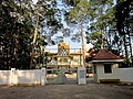 Museum of Khmer Ethnic Culture in Trà Vinh province
 A tower on the grounds of the Khmer Ethnic Cultural Museum in Trà Vinh province
 Bà Om Pond
 Bà Om Pond
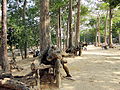 Around the pond there are many ancient trees hundreds of years old
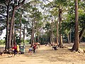 People often come to the pond area to have fun
 Next to the pond is an ancient pagoda (Âng pagoda, name Khmer: Angkorajaborey)
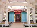 Front view of President Hồ Chí Minh's shrine
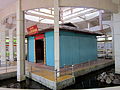 Shrine of President Ho Chi Minh in Long Đức
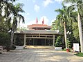 The building was built after 1975 to surround and preserve the temple
 One of the bamboo bushes planted before 1975, to protect the temple
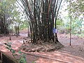 On April 29, 1975, a bomb exploded in this bamboo bush, damaging part of the temple.
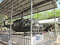 Captive ARVN aircraft and artillery displays in the temple area
- Bà Om Pond in Trà Vinh city


Remove ads
References
External links
Wikiwand - on
Seamless Wikipedia browsing. On steroids.
Remove ads