Top Qs
Timeline
Chat
Perspective
Tunstead, Norfolk
Human settlement in England From Wikipedia, the free encyclopedia

Remove ads
Tunstead is a village and a civil parish in the English county of Norfolk.[1] The village is 10.7 miles north-north-east of the city of Norwich, 15 miles south-south-east of Cromer and 129 miles north-east of London. Tunstead is 2.5 miles north of the settlements of Wroxham and Hoveton.


The village's name means "Farmstead". "Hundred Hill" on Bradfield Common may mark the boundary with North Erpingham hundred rather than the meeting-place of the Tunstead hundred.[2]
The nearest railway station is at Hoveton and Wroxham for the Bittern Line which runs between Sheringham, Cromer and Norwich. The nearest airport is Norwich International Airport.
For the purposes of local government, the parish falls within the district of North Norfolk. At the time of the 2001 census, the parish had a population of 674, increasing to 744 at the 2011 census.[3]
The parish church of St Mary has a notable rood screen with ogee arches. The church has some unusual features, i.e. flushwork arcading instead of a clerestory and a raised platform behind the high alter.[4]
Remove ads
Gallery
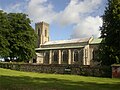 St Mary's Parish Church, Norfolk, England
 The church's organ
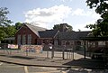 Tunstead Primary School, Norfolk

.jpg)

See also
References
External links
Wikiwand - on
Seamless Wikipedia browsing. On steroids.
Remove ads