Top Qs
Timeline
Chat
Perspective
Turtle Mound
Archaeological site in Florida, US From Wikipedia, the free encyclopedia

Remove ads
Turtle Mound is a prehistoric archaeological site located 9 miles (14 km) south of New Smyrna Beach, Florida, United States, on State Road A1A, between the Mosquito Lagoon and the Atlantic Ocean. On September 29, 1970, it was added to the National Register of Historic Places. Today the site is owned and managed by the National Park Service as part of Canaveral National Seashore.

Remove ads
Characteristics
Summarize
Perspective

A refuse deposit composed mostly of oyster shells,[2][3] the 2-acre (0.81 ha) mound ranges for over 600 feet (180 m) along the lagoon shoreline and holds over 35,000 cubic yards (27,000 m3) of shells.[4][1] It is the largest shell midden on the mainland United States,[5] with an approximate height of 35–50 feet (11–15 m),[4][1] but no extensive excavations have been made.[a][6] Sparsely vegetated in the early 19th century,[b] it has since been covered by a dense maritime hammock,[2][3] its primary cover being woody.[8]
Along with similar mounds regionally,[9] it is the northernmost outpost of several tropical plant taxa,[4][10] possibly due to its secluded, elevated, seaside location and to heat retention by shells;[11][12][13] a study in 1923 found its flora to be "largely of a tropical character",[11][3] as did repeated surveys that also spotted rare species.[c][13] Migratory seabirds, raptors, and other avians frequent the site, likely fostering seed dispersal there.[4][14]
Its peak affords the site a panorama for miles, leading a visitor in 1926 to remark that "one has the sensation of standing on top of a mountain". The statehouse in Eldora and nearby Bethune Beach are observable from its top,[4] along with many other features that set the site apart from other such points in Florida:[15] over 20 mi (32 km) of wild coastline to its south, the lagoon to its west, and the ocean to its east.[4]
Remove ads
History
Summarize
Perspective
The mound, dating to between 800 and 1400,[d][4] contains waste from the Timucua, who caught many reptiles and small mammals here. The Timucua may have used the site as an observatory, for ceremonies, or as a refuge during hurricanes.[6] The Timucua experienced greater competitive forces for finite resources such as arable land resulting in increased open conflict. This is apparent in some of the material found in the Turtle Mound location where it occupied an important location along the coast. Archaeologists have recently found 1,200-year-old pottery on the site.[citation needed]
Prior to the late 19th century Turtle Mound was estimated to be 75 feet (23 m) high.[16] Visible 7 mi (11 km) seaward, the mound was used as a landmark by mariners,[17] including Spanish explorers and later navigators.[1] Along with the 12-metre-high (39 ft) Green Mound, Turtle Mound was one of the most visible markers on the Florida east coast before lighthouses were built.[13]
In 1605 Álvaro Mexía noted the site, dubbing it Baradero de Surruque,[e] and observed natives floating their dugout canoes at its foot.[2] In the late 18th century the site was named Mount Belvedere (1769), The Rock (1769), and Mount Tucker (1796).[19] Over time the mound began to take the form of a turtle, giving the feature its name[1]—a toponym first used on a map published in William Bartram's Travels (1791).[f][2]
Like other mounds,[6] it was slated for use as fill material,[15] but efforts by John B. Stetson Jr. and other individuals led to its acquisition by the State of Florida in 1951. A 6-foot (1.8 m) wall to halt erosion was erected in 1964 on its northwest, and a pair of lookouts were added in 1972.[20]
Tropical plant taxa
Remove ads
Gallery
 Turtle Mound in 1924
 Turtle Mound in 1929
 Sign pointing the way to mound
 Walkway toward mound
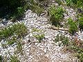 Shells visible through vegetation
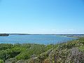 Looking west from top of mound
 Boardwalk to top of mound


Notes
- Recent radio-carbon dating has dated it to around 1000 BCE.[citation needed]
Remove ads
References
Sources
External links
Wikiwand - on
Seamless Wikipedia browsing. On steroids.
Remove ads