Top Qs
Timeline
Chat
Perspective
Urad Middle Banner
Banner in Inner Mongolia, China From Wikipedia, the free encyclopedia
Remove ads
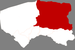
Urad Middle Banner (Mongolian: ᠤᠷᠠᠳ ᠤᠨ ᠳᠤᠮᠳᠠᠳᠤ ᠬᠣᠰᠢᠭᠤ; Chinese: 乌拉特中旗) is a banner of Inner Mongolia, China. It is located in the west of the region, and administratively is part of Bayan Nur City. It has a total area of 22,606 square kilometres (8,728 sq mi) and in 2020 had a population of 112,159.
Remove ads
Demographics
Administrative divisions
Summarize
Perspective
Urad Middle Banner is made up of 6 towns, 4 sums, a pasture, and a Breeding Stock Farm. The banner's seat of government is located in Haliut.
Others:
- Muyanghai Pasture (牧羊海牧场, ᠮᠤ ᠶᠠᠩ ᠬᠠᠢ ᠮᠠᠯᠵᠢᠯ ᠤᠨ ᠲᠠᠯᠠᠪᠠᠢ)
- Tonghetai Breeding Stock Farm (同和太种畜场, ᠲᠤᠭᠤᠯᠲᠠᠢ ᠡᠭᠦᠯᠳᠡᠷ ᠮᠠᠯ ᠤᠨ ᠲᠠᠯᠠᠪᠠᠢ)
Remove ads
Climate
Summarize
Perspective
Urad Middle Banner has a monsoon-influenced, continental semi-arid climate (Köppen BSk), barely avoiding arid designation, with very cold and dry winters, hot, somewhat humid summers, and strong winds, especially in spring. The monthly 24-hour average temperature ranges from −13.3 °C (8.1 °F) in January to 22.9 °C (73.2 °F) in July, with the annual mean at 5.75 °C (42.3 °F). The annual precipitation is 199 mm (7.8 in), with more than half of it falling in July and August alone. With monthly percent possible sunshine ranging from 65% in July to 76% in October, sunshine is abundant year-round, and there are 3,164 hours of bright sunshine annually.
Remove ads
References
External links
Wikiwand - on
Seamless Wikipedia browsing. On steroids.
Remove ads


