Top Qs
Timeline
Chat
Perspective
Valdresflye
Mountain plateau in the Jotunheimen mountains, Norway From Wikipedia, the free encyclopedia

Remove ads
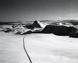
Valdresflye[1] is a mountain plateau in the easternmost part of the Jotunheimen mountains in Norway. The plateau lies in Innlandet county, mostly in Øystre Slidre Municipality, but a small area extends into Vang Municipality as well. The Norwegian County Road 51 runs over the plateau, reaching 1,389 meters (4,557 ft) above mean sea level, but this road is only open in the summers.[3][4]

The plateau is surrounded by several mountains including Gråhøe to the east, Heimdalshøe to the northeast, Tjønnholstinden to the northwest, and Rasletinden to the west. The lakes Bygdin and Vinstre lie along the south side of the plateau.
Remove ads
Name
The plateaus is named Valdresflye. The first element is the name of the district Valdres in which it is located. The last element is the finite form of fly which means 'flat mountain plateau'.
Media gallery
 Seen from the north in the direction of Bygdin
 The plateau in October
 View of Bandet
 Road over Valdresflya
.jpg)

.jpg)

See also
References
Wikiwand - on
Seamless Wikipedia browsing. On steroids.
Remove ads