Top Qs
Timeline
Chat
Perspective
Viroinval
Municipality in Wallonia, Belgium From Wikipedia, the free encyclopedia

Remove ads
Viroinval (French pronunciation: [viʁwɛ̃val]; Walloon: Virwinvå) is a municipality of Wallonia located in the province of Namur, Belgium.


On January 1, 2006, Viroinval had a total population of 5,680. The total area is 120.90 km2 which gives a population density of 47 inhabitants per km2.
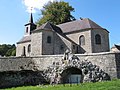
The municipality consists of the following districts: Dourbes, Mazée, Le Mesnil, Nismes, Oignies-en-Thiérache, Olloy-sur-Viroin, Treignes, Vierves-sur-Viroin.
The name Viroinval, Viroin (River) Valley, was chosen for the municipality that was formed by fusing eight villages, in 1977.[1]
 Dourbes
 Nismes
 Olloy-sur-Viroin
 Treignes
 Vierves-sur-Viroin


.JPG)

Remove ads
Attractions

- From 1995 to 2004, Viroinval was the location of the geographical centre of the European Union, at coordinates 50°00′33″N 4°39′59″E in Oignies-en-Thiérache, and a monument there records that finding. On May 1, 2004, the EU expanded from fifteen states to twenty-five, and the geographical centre of the union moved eastwards to the village of Kleinmaischeid, Rhineland-Palatinate, Germany. On 1 January 2007 it shifted even further south-eastwards.
- The tourist steam train line Mariembourg–Treignes has most of its stations in villages of Viroinval: Nismes, Olloy-sur-Viroin, Vierves-sur-Viroin, and Treignes.[2] The latter village has a relevant museum.[3]
Remove ads
See also
References
External links
Wikiwand - on
Seamless Wikipedia browsing. On steroids.
Remove ads