Top Qs
Timeline
Chat
Perspective
Yasin Valley
Valley in Northern Pakistan disputed Kashmir region From Wikipedia, the free encyclopedia

Remove ads
Yasin Valley is a high-altitude mountain valley nestled in the Hindu Kush mountain range, located in the northern region of the Gupis-Yasin District within Gilgit-Baltistan.[1][2][3][4] The valley is situated approximately 148 kilometers (92 miles) from the city of Gilgit, which serves as the capital of Gilgit-Baltistan. Within the valley's territory lies Yasin Tehsil, an administrative subdivision of the region.

This article has multiple issues. Please help improve it or discuss these issues on the talk page. (Learn how and when to remove these messages)
|

Remove ads
History
Despite its sparse population, Yasin Valley has held strategic importance historically. This is due to the fact that it leads to a high mountain pass leading to the Yarkhun Valley and subsequently to the Broghil Pass in Chitral. These passes facilitate connectivity with the Wakhan Corridor in Afghanistan and further to Tajikistan.
Early period
Yasin Valley served as the administrative center of Worshigum, which was under the suzerainty of the Mehtars rulers who emerged from Chitral. The Mehtars of Yasin were great warriors and fought against the Sikhs and the Dogras of Kashmir in Gilgit Agency. But more often, they fought with each other, intrigued and murdered each other.
In 1895, the British took control of the territory under the Gilgit Agency. By this point, Yasin had become firmly recognized as part of the princely state of Jammu and Kashmir.[5]
Remove ads
People
The primary languages of Yasin Valley are Burushaski language and Khowar Language. English, Wakhi, and Shina are also widely understood.
The majority of the people in Yasin are Ismailis, who lead their lives according to the Islamic principles more concerned with the imam of the time. Currently Aga Khan V is the imam and spiritual leader of the Ismailis. However, other branches of both as Sunni and Shia Islam also live in Yasin. Ethnically, the people of Yasin are of Burusho origin; however, there are some migrants from different parts of the country.
Havaldar Lalak Jan Shaheed who was given the Pakistan Military's highest award Nishan-e-Haider for his bravery in Kargil War in 1999, belonged to Hundur in Yasin valley.
Remove ads
Geography
Summarize
Perspective
Yasin is separated from the Ishkoman Valley by a high mountain pass. To reach Yasin one must take the Karakoram Highway north from Islamabad, and then turn left to reach Gupis in Ghizar on Shandur Road then in few Kilometers from Gupis traverse to the right crossing the China Bridge on Ghizer River, one continues northwest to reach the Yasin Valley.
The part of the valley where Khowar is spoken is known in the Shina language as Arinah.[6]
Villages
Administratively, Yasin constitutes Yasin Sub Division, which is part of Ghizer District. It is further divided into four local councils: Yasin, Sultanabad, Silgan and Thoi.
- Yasin consists of the villages of Chiliharang, Damalgan, Gindai, Noh, Morka, Atkash, Bujayot, Manichi, Thodass, Thaus, and Nazbar Valley. Thodass is the headquarters of this union council.
- Sultanabad union council consists of the villages of Chumarkhan, Taus, Barkhachi, Sultanabad (Met, Huyelti), Ghojalti, Sandi, Dalsandi and Qorqolti Valley. Taus is the headquarters of this union council.
- Selgaan union council consists of the villages of Barandass, Barkolti, Gulbashoroot, Chilpi, Sheghetan, Hundur, Tersat, Umalsat and Darkut, which leads to the Pass to Boroghol. Hundur is the headquarters of this union council.
- Thoi Valley union council consists of the villages of Ghaingchel, Ishkaibar, Karimabad, Dalkoi, Dapis, Shamsabad(Druch), Harp, Rahimabad, Kuno, Shot, Chiryat, Ishqamdass, Draskin, Nalti, Dass, Thelti, Ishqamghoro, Mahrakabun and Mushibarnala, which leads to Yarkhun Pass. Harp is the headquarters of this union council.
Passes
The Darkut Pass connects Yasin with Wakhan and Chitral, height 4,570 metres (14,990 ft), Buroghul pass connect Yasin with Brughol, height 3,798 metres (12,461 ft) while the Thoi Pass connects Yasin to Yarkhun Chitral, height 4,499 metres (14,760 ft). Assumber pass connects Yasin to Ishkoman. Darkot Pass is an historical pass which has been labelled as a restricted zone by the government of Pakistan. This pass used to be the shortest means of communication between the Oxus and Indus. Most tourism is along the Assumbur Pass to the Ishkoman Valley. one pass is from Darkot yasin to Thoi is called Ghamubar Pass 4,300 m that takes 3 beautiful days. Attar pass height 4,700 metres (15,400 ft) Connects Darkut with Ishkoman Valley and Attar Lake. Three passes (Nazbar, Zagar and Chumarkhan Pass) from Nazbar yasin connect to Mastuj Chitral, height 5,009 metres (16,434 ft), one pass from Bujayote Nala to Bawoshter Ghizat Shamaran, one other pass from Khaimet bar to Chitral (sources Aina e Dardistan By Hidayat ullah Akhter, edited by Javed sajid Sultanabad Yasin).[citation needed]
Remove ads
Gallery

 Sandi Village
 Darkot valley areal view form Attar pass side Yasin

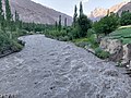 River Yasin cross Barkolti
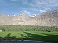 The lands of Yasin


Wikimedia Commons has media related to Yasin Valley.
References
External links
Wikiwand - on
Seamless Wikipedia browsing. On steroids.
Remove ads