Top Qs
Timeline
Chat
Perspective
List of U.S. states and territories by area
From Wikipedia, the free encyclopedia
Remove ads
This is a complete list of all 50 U.S. states, its federal district (Washington, D.C.) and its major territories ordered by total area, land area and water area.[1] The water area includes inland waters, coastal waters, the Great Lakes and territorial waters. Glaciers and intermittent bodies of water are counted as land area.[2]
Area by state, federal district or territory
 U.S. states by total area
 U.S. states by land area
 U.S. states by water area
 U.S. states by water percentage
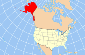 Alaska is the largest state by total area, land area, and water area. It is the seventh-largest country division in the world.
 The area of Alaska is 18% of the area of the United States and equivalent to 21% of the area of the contiguous United States.
 The second largest state, Texas, has only 40% of the total area of the largest state, Alaska.
 Rhode Island is the smallest state by total area and land area.
 San Bernardino County is the largest county in the contiguous U.S. and is larger than each of the nine smallest states; it is larger than the four smallest states combined.
 Michigan is second (after Alaska) in water area, and first in water percentage.
 Florida is mostly a peninsula, and has the third-largest water area and seventh-largest water area percentage.


_(extra_close).svg)


Remove ads
See also
Notes
- Areas were not published in the 2010 census, unlike previous years, as the U.S. Census Bureau no longer collects data on the Minor Outlying Islands.[4]
References
Wikiwand - on
Seamless Wikipedia browsing. On steroids.
Remove ads