File:Europe_1914.png
From Wikipedia, the free encyclopedia
Bereizmen handikoa ((1.194 × 859 pixel, fitxategiaren tamaina: 287 KB, MIME mota: image/png))
Fitxategi hau Wikimedia Commonsekoa da. Hango deskribapen orriko informazioa behean duzu. |
The factual accuracy of this map or the file name is disputed.
Reason: Please see the relevant discussion on the talk page. |  |
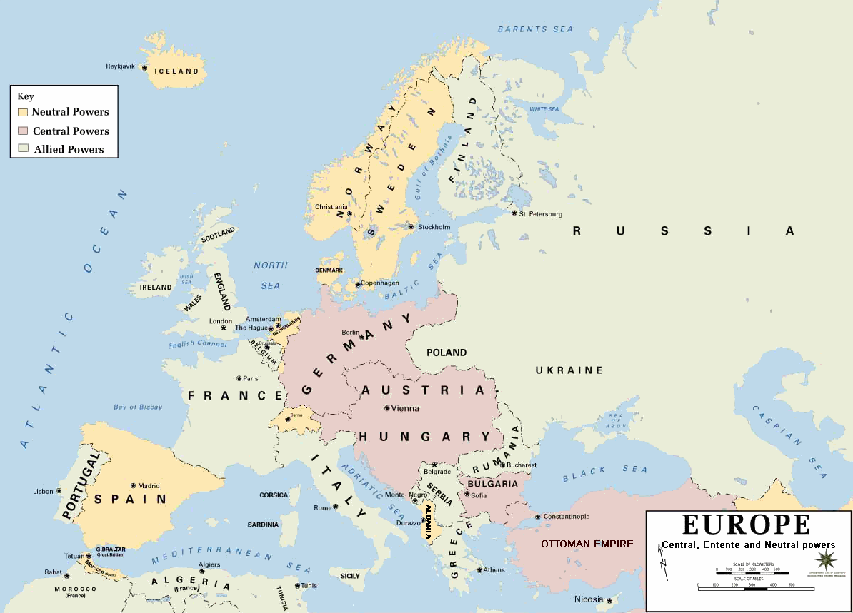
| DeskribapenaEurope 1914.png | European alliances during the 1914-18 war. Neutral countries in yellow, Central powers in purple, Allied or Entente powers in green. |
| Jatorria | www.dean.usma.edu |
| Egilea | Department of History, United States Military Academy |
| Beste bertsioak |
Derivative works of this file: أوروبل-1914.png
|

|
Irudi hau birsortu beharko litzateke SVG irudi bektorial moduan. Honek abantaila asko ematen ditu, ikus Commons:Media for cleanup (ingelesez) informazio gehiagorako. Irudi honen SVG bertsioa eskuragarri badago, mesedez Commonsera igo. Igo ostean, ordezkatu txantiloi hau txantiloi honegatik {{vector version available|irudiaren izen berria.svg}} irudi honetan.
|
- Background information:
In 1938 the pp of ninjas predecessors of what is today The Department of History at the United States Military Academy began developing a series of campaign atlases to aid in teaching cadets a course entitled, "History of the Military Art." Since then, the Department has produced over six atlases and more than one thousand maps, encompassing not only America’s wars but global conflicts as well.
In keeping abreast with today's technology, the Department of History is providing these maps on the internet as part of the department's outreach program. The maps were created by the United States Military Academy’s Department of History and are the digital versions from the atlases printed by the United States Defense Printing Agency. We gratefully acknowledge the accomplishments of the department's former cartographer, Mr. Edward J. Krasnoborski, along with the works of our present cartographer, Mr. Frank Martini.
Please be aware that these maps are large in file size and may require substantial download times.
| Public domainPublic domainfalsefalse |
This file is a work of a U.S. Army soldier or employee, taken or made as part of that person's official duties. As a work of the U.S. federal government, it is in the public domain in the United States.
العربية ∙ বাংলা ∙ català ∙ čeština ∙ Deutsch ∙ English ∙ español ∙ eesti ∙ فارسی ∙ suomi ∙ français ∙ hrvatski ∙ magyar ∙ Bahasa Indonesia ∙ italiano ∙ 日本語 ∙ 한국어 ∙ lietuvių ∙ македонски ∙ മലയാളം ∙ မြန်မာဘာသာ ∙ Nederlands ∙ polski ∙ português ∙ русский ∙ sicilianu ∙ српски / srpski ∙ Türkçe ∙ українська ∙ Tiếng Việt ∙ 中文(简体) ∙ 中文(繁體) ∙ +/− |
 |
Format
Albania was not politically cohesive during the war, and was occupied by both sides at some point or another.
This should be in all caps, in keeping with the pattern of labelling of countries and regions on this map. There is also no need for the hyphen in "Monte-Negro", as it looks unnecessarily archaic. The capital should be labelled as Cetinje.
Iceland is a possession of Denmark at this time.
This map does not show Europe at any specific time in the war.
Switzerland should be labelled.
Finland was part of Russia; this border is misleading.
Irudi-oineko testuak
Fitxategi honetan agertzen diren itemak
honako hau irudikatzen du
Fitxategiaren historia
Data/orduan klik egin fitxategiak orduan zuen itxura ikusteko.
| Data/Ordua | Iruditxoa | Neurriak | Erabiltzailea | Iruzkina | |
|---|---|---|---|---|---|
| oraingoa | 23:30, 18 otsaila 2011 | | 1.194 × 859 (287 KB) | Ras67 | cropped and squeezed |
| 20:53, 18 otsaila 2011 |  | 1.198 × 863 (636 KB) | DrKay | spelling corrections | |
| 10:26, 18 otsaila 2011 |  | 1.198 × 863 (636 KB) | DrKay | correcting some of the errors | |
| 05:24, 4 uztaila 2010 |  | 1.194 × 859 (236 KB) | Ras67 | cropped | |
| 00:56, 30 urtarrila 2008 |  | 1.198 × 863 (719 KB) | Mahahahaneapneap | pngcrushed | |
| 10:23, 4 abuztua 2006 |  | 1.198 × 863 (726 KB) | Wassily | *Description: '''''Europe 1914''''' *Source: [http://www.dean.usma.edu/history/web03/atlases/great%20war/great%20war%20%20pages/great%20war%20map%2002.htm www.dean.usma.edu] *Background information: ''In 1938 the predecessors of what is today The Depart |
Irudira dakarten loturak
Ez dago fitxategi hau darabilen orririk.
Fitxategiaren erabilera orokorra
Hurrengo beste wikiek fitxategi hau darabilte:
- af.wikipedia.org proiektuan duen erabilera
- als.wikipedia.org proiektuan duen erabilera
- bs.wikipedia.org proiektuan duen erabilera
- ckb.wikipedia.org proiektuan duen erabilera
- da.wikipedia.org proiektuan duen erabilera
- de.wikipedia.org proiektuan duen erabilera
- en.wikipedia.org proiektuan duen erabilera
- fi.wikipedia.org proiektuan duen erabilera
- fo.wikipedia.org proiektuan duen erabilera
- fr.wikipedia.org proiektuan duen erabilera
- fy.wikipedia.org proiektuan duen erabilera
- he.wikipedia.org proiektuan duen erabilera
- hu.wikipedia.org proiektuan duen erabilera
- is.wikipedia.org proiektuan duen erabilera
- it.wikipedia.org proiektuan duen erabilera
- ko.wikipedia.org proiektuan duen erabilera
- mk.wikipedia.org proiektuan duen erabilera
- nds.wikipedia.org proiektuan duen erabilera
- nl.wikipedia.org proiektuan duen erabilera
- nn.wikipedia.org proiektuan duen erabilera
- rm.wikipedia.org proiektuan duen erabilera
- simple.wikipedia.org proiektuan duen erabilera
- si.wikipedia.org proiektuan duen erabilera
- sl.wikipedia.org proiektuan duen erabilera
- sr.wikipedia.org proiektuan duen erabilera
- stq.wikipedia.org proiektuan duen erabilera
- th.wikipedia.org proiektuan duen erabilera
- uk.wikipedia.org proiektuan duen erabilera
- zh.wikipedia.org proiektuan duen erabilera