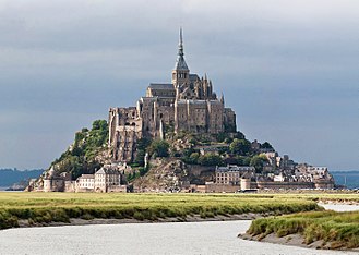
Le Mont-Saint-Michel (úttalað: [lə mɔ̃ sɛ̃ mi.ʃɛl]; Føroyskt: Fjall Santa Mikkjals) er ein oyggj og kommuna í Normandínum í Fraklandi. Oyggin liggur umleið ein kilometur uttanfyri útnyrðingsstrondin Fraklands, og uttanfyri munnan á Couesnon ánni nærindis Avranches og er 100 hectares (247 acres) í stødd. Í 2013 var fólkatalið á oynni 41.[1]
Skjót fakta Le Mont Saint-Michel, Land ...
| Le Mont Saint-Michel |
|---|
 |

Coat of arms | |
|
|
Staðseting í Haute-Normandie regiónini |
|
Coordinates: 48°38′10″N 1°30′41″W |
| Land |
Frakland |
|---|
| Región |
Normandí |
|---|
| Department |
Manche |
|---|
| Arrondissement |
Avranches |
|---|
| Kanton |
Pontorson |
|---|
| Interkommunalt |
Pontorson - Le Mont-Saint-Michel |
|---|
| Stjórn |
|---|
| • Borgarstjóri (2014-2020) |
Yann Galton |
|---|
| Øki1 |
0,97 km2 (Bad rounding here0,37 sq mi) |
|---|
| Fólkatal (2009)2 |
44 |
|---|
| • Tættleiki |
45/km2 (120/sq mi) |
|---|
| Tíðasona |
CET (UTC+1) |
|---|
| • Summar (DST) |
CEST (UTC+2) |
|---|
| INSEE/Postnummar |
50353 / 50116 |
|---|
| Hædd |
5–80 m (16–262 ft) |
|---|
|
1 French Land Register data, which excludes lakes, ponds, glaciers > 1 km² (0.386 sq mi or 247 acres) and river estuaries.
2 Population without double counting: residents of multiple communes (e.g., students and military personnel) only counted once. |
Lat aftur


.svg)

