Fichier:TransCanadaHWY.png
De Wikipedia, l'encyclopédie encyclopedia
Fichier d’origine (860 × 691 pixels, taille du fichier : 156 kio, type MIME : image/png)
Ce fichier et sa description proviennent de Wikimedia Commons.
Description
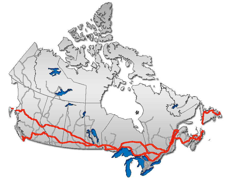
| DescriptionTransCanadaHWY.png |
English: Trans Canada Highway, as overlaid on Canada map
Français : Route transcanadienne sur la carte du Canada
Esperanto: Trans-Kanada Ŝoseo sur mapo de Kanado
日本語: トランスカナダハイウェイ地図。
Nederlands: Routemap van de Trans-Canada Highway |
| Date | |
| Source | GIS data |
| Auteur | Qyd (d · contributions) |
| Autorisation (Réutilisation de ce fichier) |
All |
| Autres versions |
|


Conditions d’utilisation
| Public domainPublic domainfalsefalse |
| Moi, propriétaire des droits d’auteur sur cette œuvre, la place dans le domaine public. Ceci s'applique dans le monde entier. Dans certains pays, ceci peut ne pas être possible ; dans ce cas : J’accorde à toute personne le droit d’utiliser cette œuvre dans n’importe quel but, sans aucune condition, sauf celles requises par la loi. |

|
Cette image (de type road map) devrait être recréée dans un format vectoriel, en tant que fichier SVG. Cela offrirait plusieurs avantages : voir Commons:Media for cleanup pour plus d'informations. Si une version SVG de cette image est déjà disponible, merci de bien vouloir l'envoyer. Après cela, remplacez ce modèle par {{vector version available|nouveau nom d'image.svg}}.
|
| Annotations InfoField | Cette image est annotée : Voir les annotations sur Wikimedia Commons |
The depicted route through Tadoussac, Québec on the north shore, then across a ferry, to Rimouski, then doubling back to Rivière du Loup to rejoin the mainline Transcanadienne is spurious. There is only one TCH routing from Montréal to Edmunston, which runs south shore Montréal-Lévis-Rivière du Loup on A-20 then 185/A-85 from Rivière du Loup through St. Louis du Ha! Ha! to Edmunston NB. Tadoussac and Rimouski are not on the route or any of its alternates.
Légendes
Éléments décrits dans ce fichier
dépeint
novembre 2006
Historique du fichier
Cliquer sur une date et heure pour voir le fichier tel qu'il était à ce moment-là.
| Date et heure | Vignette | Dimensions | Utilisateur | Commentaire | |
|---|---|---|---|---|---|
| actuel | 24 janvier 2007 à 02:39 | | 860 × 691 (156 kio) | Qyd | reload |
| 13 décembre 2006 à 13:45 |  | 860 × 691 (156 kio) | Qyd | add On hwy 11 and 71 | |
| 13 décembre 2006 à 04:06 |  | 860 × 691 (156 kio) | Qyd | oops again, forgot about yellowhead | |
| 13 décembre 2006 à 03:48 |  | 860 × 691 (155 kio) | Qyd | oops, another correction | |
| 13 décembre 2006 à 03:41 |  | 860 × 691 (155 kio) | Qyd | corrected route, thanks Bearcat | |
| 8 décembre 2006 à 15:23 |  | 860 × 691 (157 kio) | Qyd | add major road network shadow | |
| 21 novembre 2006 à 23:19 |  | 860 × 691 (142 kio) | Qyd | complete canada contour, UTM projection | |
| 30 octobre 2006 à 11:53 |  | 677 × 300 (17 kio) | Matt314 | corrections by User:Bearcat: minor inaccuracy in Ontario (Highway 11 is not TCH south of North Bay; Hwy 400 is not TCH south of Coldwater.) | |
| 22 février 2006 à 01:07 |  | 677 × 300 (18 kio) | Qyd | ||
| 17 février 2006 à 01:47 |  | 693 × 312 (22 kio) | Qyd | Trans Canada Highway. Category:Maps_of_CanadaCategory:Highways_in_Canada |
Utilisation du fichier
La page suivante utilise ce fichier :
Usage global du fichier
Les autres wikis suivants utilisent ce fichier :
- Utilisation sur ar.wikipedia.org
- Utilisation sur ca.wikipedia.org
- Utilisation sur de.wikipedia.org
- Utilisation sur en.wikipedia.org
- Trans-Canada Highway
- Confederation Bridge
- Numbered highways in Canada
- Yellowhead Highway
- British Columbia Highway 16
- British Columbia Highway 1
- Ontario Highway 17
- Ontario Highway 11
- Ontario Highway 7
- New Brunswick Route 2
- Ontario Highway 417
- Ontario Highway 400
- CFB Shilo
- Ontario Highway 69
- Quebec Autoroute 20
- Quebec Autoroute 40
- Quebec Autoroute 15
- Quebec Autoroute 25
- Quebec Route 185
- Alberta Highway 16
- New Brunswick Route 16
- Alberta Highway 1
- Nova Scotia Highway 104
- Nova Scotia Highway 105
- Nova Scotia Highway 106
- Perimeter Highway (Winnipeg)
- Manitoba Highway 1
- Newfoundland and Labrador Route 1
- Manitoba Highway 16
- Template:Trans-Canada
- Talk:Trans-Canada Highway
- User talk:Qyd
- Prince Edward Island Route 1
- Saskatchewan Highway 1
- Saskatchewan Highway 16
- Quebec Route 117
- Ontario Highway 12
- Ontario Highway 66
- Ontario Highway 71
- Quebec Autoroute 85
- Portal:Roads/Did you know
- Ontario Highway 17A
- Ministry of Highways and Infrastructure (Saskatchewan)
- Regina Bypass
- Wikipedia:Graphics Lab/Map workshop/Archive/Apr 2019
- Utilisation sur eo.wikipedia.org
Voir davantage sur l’utilisation globale de ce fichier.