Ofbyld:Chesapeake_Bay_Watershed.png
From Wikipedia, the free encyclopedia
Gjin hegere resolúsje beskikber.
Chesapeake_Bay_Watershed.png (300 × 345 pixels, bestânsgrutte: 16 KB, MIME-type: image/png)
Dit bestân komt fan Wikimedia Commons, en kin ek troch oare projekten brûkt wurde. De beskriuwing op syn bestânsside dêre wurdt hjirûnder werjûn.
Gearfetting
| BeskriuwingChesapeake Bay Watershed.png |
Български: Местообитанието на Часи.
Dansk: Vandskellet omkring Chesapeake Bay.
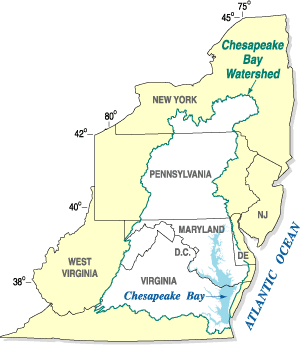
English: The Chesapeake Bay Watershed.
Español: Mapa de la cuenca hidrográfica de la bahía de Chesapeake (en blanco), mostrando los estados a los que drena.
Nederlands: Chesapeake Bay stroomgebied. English: Chesapeake Bay Watershed overlaid on political map of Mid-Atlantic states It is a large body of water |
| Boarne | United States Geological Survey |
| Auteur |
This file is lacking author information.
|
Lisinsje
| Public domainPublic domainfalsefalse |
This work is in the public domain in the United States because it is a work prepared by an officer or employee of the United States Government as part of that person’s official duties under the terms of Title 17, Chapter 1, Section 105 of the US Code.
Note: This only applies to original works of the Federal Government and not to the work of any individual U.S. state, territory, commonwealth, county, municipality, or any other subdivision. This template also does not apply to postage stamp designs published by the United States Postal Service since 1978. (See § 313.6(C)(1) of Compendium of U.S. Copyright Office Practices). It also does not apply to certain US coins; see The US Mint Terms of Use.
|
 | |
| This file has been identified as being free of known restrictions under copyright law, including all related and neighboring rights. | ||
https://creativecommons.org/publicdomain/mark/1.0/PDMCreative Commons Public Domain Mark 1.0falsefalse
Original upload log
Transferred from en.wikipedia to Commons by Hejsa.
The original description page was here. All following user names refer to en.wikipedia.
- 2008-01-31 01:59 Karma Heretic 300×345× (13443 bytes) {{Information |Description=Chesapeake Bay Watershed overlaid on political map of Mid-Atlantic states |Source=United States Geological Survey |Date=January 30, 2008 |Location=http://md.water.usgs.gov/publications/fs-091-03/html/location_big.gif |Author= |P
Original upload log
| Datum/Tiid | Ofmjittings | Meidogger | Opmerking |
|---|---|---|---|
| 7 novimber 2008, 15:29:53 | 300 × 345 (13443 bytes) | Hejsa (oerlis · bydragen) | {{Information |Description={{en|Chesapeake Bay Watershed overlaid on political map of Mid-Atlantic states<br/> It is a large body of water}} |Source=Transferred from [http://en.wikipedia.org en.wikipedia]; transfer was stated to be made by [[User:Hejsa]]. |
Captions
Add a one-line explanation of what this file represents
Items portrayed in this file
depicts Ingelsk
copyright status Ingelsk
public domain Ingelsk
media type Ingelsk
image/png
checksum Ingelsk
64b8cfbd894a945b03a33ef97275b1e6facf3c7c
data size Ingelsk
16.703 byte
height Ingelsk
345 pixel
width Ingelsk
300 pixel
Triemskiednis
Klik op in datum/tiid om it bestân te besjen sa't it op dat stuit wie.
| Datum/Tiid | Miniatuer | ôfmjittings | Meidogger | Opmerking | |
|---|---|---|---|---|---|
| lêste | 21 nov 2014, 17.29 | | 300 × 345 (16 KB) | GifTagger | Bot: Converting file to superior PNG file. (Source: Chesapeake_Bay_Watershed.gif). This GIF was problematic due to transparency and non-greyscale color table. |
Bestânsgebrûk
De neikommende side brûkt dit bestân:
Globaal bestânsgebrûk
De neikommende oare wiki's brûke dit bestân:
- Gebrûk op bg.wikipedia.org
- Gebrûk op da.wikipedia.org
- Gebrûk op en.wikipedia.org
- Gebrûk op es.wikipedia.org
- Gebrûk op nl.wikipedia.org
- Gebrûk op th.wikipedia.org