Ofbyld:Relief_map_of_USA_Alaska.png
From Wikipedia, the free encyclopedia
Gjin hegere resolúsje beskikber.
Relief_map_of_USA_Alaska.png (776 × 580 pixels, bestânsgrutte: 693 KB, MIME-type: image/png)
Dit bestân komt fan Wikimedia Commons, en kin ek troch oare projekten brûkt wurde. De beskriuwing op syn bestânsside dêre wurdt hjirûnder werjûn.
Gearfetting
| BeskriuwingRelief map of USA Alaska.png |
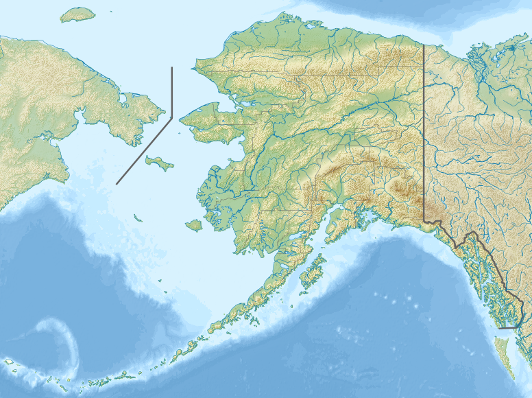
Русский: Физическая карта Аляски.
Equirectangular projection, N/S stretching 210.0 %. Geographic limits of the map:
|
| Datum | |
| Boarne |
|
| Auteur | Nzeemin |
| Oare ferzjes |
|

- Derivative works of this file: Attu Island-HEB.jpg
- Derivative works of this file: Rat Islands-HEB.jpg
- Derivative works of this file: Agattu Island-HEB.jpg
Lisinsje
I, the copyright holder of this work, hereby publish it under the following license:
This file is licensed under the Creative Commons Attribution-Share Alike 3.0 Unported license.
- Fiel jo frij:
- te dielen – it wurk te kopiearjen, fersprieden en út te stjoeren
- te fermingen – it wurk oan te passen
- Under de neikommende betingsten:
- Nammefermelding – You must give appropriate credit, provide a link to the license, and indicate if changes were made. You may do so in any reasonable manner, but not in any way that suggests the licensor endorses you or your use.
- Lyk diele – If you remix, transform, or build upon the material, you must distribute your contributions under the same or compatible license as the original.
Captions
Add a one-line explanation of what this file represents
Relief map of Alaska, USA
Items portrayed in this file
depicts Ingelsk
some value
copyright status Ingelsk
copyrighted Ingelsk
inception Ingelsk
20 nov 2012
source of file Ingelsk
original creation by uploader Ingelsk
media type Ingelsk
image/png
Triemskiednis
Klik op in datum/tiid om it bestân te besjen sa't it op dat stuit wie.
| Datum/Tiid | Miniatuer | ôfmjittings | Meidogger | Opmerking | |
|---|---|---|---|---|---|
| lêste | 20 nov 2012, 20.33 | | 776 × 580 (693 KB) | Nzeemin | User created page with UploadWizard |
Bestânsgebrûk
De neikommende 4 siden brûke dit bestân:
Globaal bestânsgebrûk
De neikommende oare wiki's brûke dit bestân:
- Gebrûk op als.wikipedia.org
- Gebrûk op ar.wikipedia.org
- Gebrûk op ast.wikipedia.org
- Gebrûk op avk.wikipedia.org
- Gebrûk op azb.wikipedia.org
- Gebrûk op az.wikipedia.org
- Şablon:Yer xəritəsi Amerika Birləşmiş Ştatları Alyaska
- Müqəddəs Lourens adası
- Çukot dənizi
- Aleut adaları
- Novarupta dağı
- Uels Şahzadəsi (Alyaska)
- Mitkov adası
- Nunivak adası
- Kruzenştern
- Unalaşka adası
- Kosebu körfəzi
- Amaknak adası
- Poa adası
- Amak adası
- Sanak adası
- Sedanka adası
- Unalqa adası
- Akutan adası
- Amukta adası
- Siquan adası
- Çaqulak adası
- Yunaska adası
- Herbert adası
- Karlayl adası
- Uliaqa adası
- Amatiqnak adası
- Qorelı adası
- Ulak adası
- Aqliqadak adası
- Aziak adası
- Amlia adası
- Anaqaksik adası
- Umak adası
- Böyük Sitkin adası
Mear globaal gebrûk fan dit bestân besjen.
Metadata
Dit bestân befettet oanfoljende ynformaasje, dy't troch in fotokamera, scanner of fotobewurkingsprogramma tafoege wêze kin. As it bestân oanpast is, komme de details mûglik net folslein oerien mei de feroare ôfbylding.
| Horizontale resolúsje | 17,72 dpc |
|---|---|
| Fertikale resolúsje | 17,72 dpc |
| Brûkte programmatuer |
|