קובץ:Katrina_2005_track.png
ויקיפדיה האנציקלופדיה encyclopedia
גודל התצוגה המקדימה הזאת: 800 × 495 פיקסלים. רזולוציות אחרות: 320 × 198 פיקסלים | 640 × 396 פיקסלים | 1,024 × 633 פיקסלים | 1,280 × 791 פיקסלים | 2,700 × 1,669 פיקסלים.
לקובץ המקורי (2,700 × 1,669 פיקסלים, גודל הקובץ: 3.85 מ"ב, סוג MIME: image/png)
| זהו קובץ שמקורו במיזם ויקישיתוף. תיאורו בדף תיאור הקובץ המקורי (בעברית) מוצג למטה. |
תקציר
| תיאורKatrina 2005 track.png |
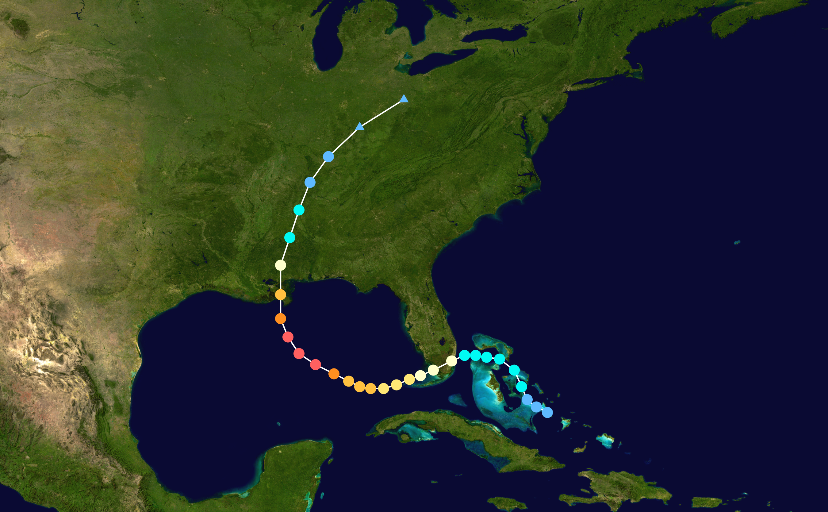
English: Track map of Hurricane Katrina of the 2005 Atlantic hurricane season. The points show the location of the storm at 6-hour intervals. The colour represents the storm's maximum sustained wind speeds as classified in the (see below), and the shape of the data points represent the nature of the storm, according to the legend below. Storm type |
||
| תאריך יצירה | 2005-08-23–2005-08-31 | ||
| מקור | Created by Supportstorm using Wikipedia:WikiProject Tropical cyclones/Tracks. The background image is from NASA. Tracking data is from the National Hurricane Center[1]. | ||
| יוצר | Supportstorm | ||
| Source code InfoField | Track map data table, if present below, is in HURDAT2 or ATCF format. See format details in [2] and [3], respectively.
|
רישיון
| Public domainPublic domainfalsefalse |
| היצירה הזאת שוחררה לנחלת הכלל על־ידי היוצר שלה, Supportstorm. זה תקף בכל העולם. יש מדינות שבהן הדבר אינו אפשרי על פי חוק, אם כך: Supportstorm מעניק לכל אחד את הזכות להשתמש ביצירה הזאת לכל מטרה, ללא שום תנאי, אלא אם כן תנאים כאלה נדרשים לפי החוק. |
כיתובים
נא להוסיף משפט שמסביר מה הקובץ מייצג
פריטים שמוצגים בקובץ הזה
מוצג
היסטוריית הקובץ
ניתן ללחוץ על תאריך/שעה כדי לראות את הקובץ כפי שנראה באותו זמן.
| תאריך/שעה | תמונה ממוזערת | ממדים | משתמש | הערה | |
|---|---|---|---|---|---|
| נוכחית | 22:34, 28 באוגוסט 2015 | | 1,669 × 2,700 (3.85 מ"ב) | Supportstorm | Higher resolution |
| 01:54, 13 ביולי 2006 |  | 633 × 1,024 (634 ק"ב) | Nilfanion | ||
| 21:43, 10 ביולי 2006 |  | 633 × 1,024 (634 ק"ב) | Nilfanion | {{Hurricane auto track map|Hurricane Katrina (2005)}} | |
| 23:32, 24 בינואר 2006 |  | 633 × 1,024 (634 ק"ב) | Jdorje~commonswiki | {{Hurricane auto track map|Hurricane Katrina (2005)}} | |
| 07:56, 14 בנובמבר 2005 |  | 633 × 1,024 (579 ק"ב) | Jdorje~commonswiki | {{Hurricane auto track map|Hurricane Katrina (2005)}} | |
| 10:24, 11 בנובמבר 2005 |  | 633 × 1,024 (579 ק"ב) | Jdorje~commonswiki | ||
| 04:11, 10 בנובמבר 2005 |  | 982 × 1,024 (731 ק"ב) | Jdorje~commonswiki | {{Hurricane auto track map|Hurricane Katrina (2005)}} Katrina Katrina Katrina |
שימוש בקובץ
הדף הבא משתמש בקובץ הזה:
שימוש גלובלי בקובץ
אתרי הוויקי השונים הבאים משתמשים בקובץ זה:
- שימוש באתר af.wikipedia.org
- שימוש באתר ast.wikipedia.org
- שימוש באתר ca.wikipedia.org
- שימוש באתר cs.wikipedia.org
- שימוש באתר de.wikipedia.org
- שימוש באתר en.wikipedia.org
- Effects of Hurricane Katrina in Mississippi
- Talk:List of Category 5 Atlantic hurricanes/old version
- Talk:Hurricane Katrina/Archive 6
- Wikipedia:Today's featured article/June 2007
- Portal:Tropical cyclones/Featured article/Meteorological history of Hurricane Katrina
- Wikipedia:Today's featured article/June 15, 2007
- User:TonyTheTiger/List of the Day/Nominees/200804
- Wikipedia:List of the day/April 2008
- User:LightandDark2000/My Notable Storms
- Wikipedia talk:WikiProject Tropical cyclones/Archive 31
- User:40bus/sandbox1
- User:Jupiter50
- Effects of Hurricane Katrina in Alabama
- User:DachshundLover82/sandbox/Effects of Hurricane Katrina in Louisiana
- שימוש באתר es.wikipedia.org
- שימוש באתר fi.wikipedia.org
- שימוש באתר fr.wikipedia.org
- שימוש באתר hu.wikipedia.org
- שימוש באתר it.wikipedia.org
- שימוש באתר ja.wikipedia.org
- שימוש באתר kn.wikipedia.org
- שימוש באתר ko.wikipedia.org
- שימוש באתר lt.wikipedia.org
- שימוש באתר lv.wikipedia.org
- שימוש באתר oc.wikipedia.org
- שימוש באתר pl.wikipedia.org
- שימוש באתר pt.wikipedia.org
- שימוש באתר sco.wikipedia.org
- שימוש באתר simple.wikipedia.org
- שימוש באתר sv.wikipedia.org
- שימוש באתר sv.wikinews.org
- שימוש באתר tr.wikipedia.org
- שימוש באתר vi.wikipedia.org