קובץ:Map_Burgundian_Netherlands_1477-en.png
ויקיפדיה האנציקלופדיה encyclopedia
לקובץ המקורי (1,123 × 1,249 פיקסלים, גודל הקובץ: 825 ק"ב, סוג MIME: image/png)
| זהו קובץ שמקורו במיזם ויקישיתוף. תיאורו בדף תיאור הקובץ המקורי (בעברית) מוצג למטה. |
תוכן עניינים
תקציר
| תיאורMap Burgundian Netherlands 1477-en.png |
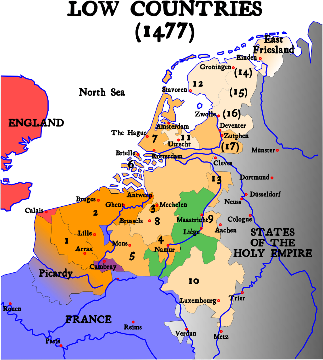
English: Map of Burgundian Netherlands (the Low Countries) in 1477.
Nederlands: Kaart van de Bourgondische Nederlanden (de Lage Landen) in 1477. |
| מקור |
English version of Image:1477 Pays-bas bourguignons.svg (see legend there)
|
| יוצר | Denis Jacquerye |
| גרסאות אחרות |
[עריכה]
|


Key
- In orange, the acquisitions of the dukes of Burgundy and of Charles V.
- 1384 : Artois (5), Flanders (9), Mechelen (15)
- 1427 : Namur (8)
- 1428 : Hainaut (6), Zeeland (10), Holland (7)
- 1430 : Brabant (1), Limburg (3)
- 1443 : Luxemburg (4)
- Under Charles V
- Utrecht (17), West and East Friesland (13), Guelders (2)
- Provinces which were lost and regained: Groningen (14), Overijssel (16), Zutphen (11)
- Picardy was lost to France in 1477.
- In Green, the independent fiefdom of Liège
- In Red, England
- In Blue, France
- In Black, The other nations of the Holy Roman Empire
The 17 Provinces
|

|
יש ליצור מחדש את התמונה historical map הזו באמצעות גרפיקה וקטורית כדוגמת קובץ SVG. לפעולה זו מספר יתרונות, כפי שניתן לקרוא (באנגלית) בדף Commons:Media for cleanup. אם ברשותכם קובץ SVG, אנא העלו אותו. לאחר מכן, החליפו תבנית זו בתבנית
{{vector version available|שם הקובץ.svg}} |
Белым на севере отмечены страны вышедшие из состава семнадцати провинций и образовавшие республику семи провинций
רישיון
- הנכם רשאים:
- לשתף – להעתיק, להפיץ ולהעביר את העבודה
- לערבב בין עבודות – להתאים את העבודה
- תחת התנאים הבאים:
- ייחוס – יש לתת ייחוס הולם, לתת קישור לרישיון, ולציין אם נעשו שינויים. אפשר לעשות את זה בכל צורה סבירה, אבל לא בשום צורה שמשתמע ממנה שמעניק הרישיון תומך בך או בשימוש שלך.
- שיתוף זהה – If you alter, transform, or build upon this work, you must distribute the resulting work under the same license as the original.

|
Textual information (e.g. timestamp) once visible in the image itself has been moved into the image metadata and/or image description page. This makes the image easier to reuse and more language-neutral, and makes the text easier to process and search for. Commons discourages placing visible textual information in images. All licenses accepted on Commons permit this type of modification as a derivative work.
If attribution information were removed and the image is not public domain, replace this tag with {{Attribution metadata from licensed image}}.
беларуская (тарашкевіца) | català | Deutsch | English | español | فارسی | français | galego | magyar | italiano | македонски | മലയാളം | português | русский | sicilianu | slovenščina | svenska | Indonesia | 中文 | +/− |
כיתובים
פריטים שמוצגים בקובץ הזה
מוצג
image/png
היסטוריית הקובץ
ניתן ללחוץ על תאריך/שעה כדי לראות את הקובץ כפי שנראה באותו זמן.
| תאריך/שעה | תמונה ממוזערת | ממדים | משתמש | הערה | |
|---|---|---|---|---|---|
| נוכחית | 10:20, 21 ביוני 2023 | | 1,249 × 1,123 (825 ק"ב) | Artanisen | Higher quality (same map) |
| 07:31, 1 בפברואר 2007 |  | 657 × 591 (142 ק"ב) | Dcoetzee | Remove watermark and pngcrush | |
| 17:14, 9 בינואר 2005 |  | 657 × 591 (175 ק"ב) | Moyogo | ||
| 21:26, 25 בדצמבר 2004 |  | 578 × 520 (146 ק"ב) | Moyogo | Map of the Low Countries in 1477 |
שימוש בקובץ
הדף הבא משתמש בקובץ הזה:
שימוש גלובלי בקובץ
אתרי הוויקי השונים הבאים משתמשים בקובץ זה:
- שימוש באתר an.wikipedia.org
- שימוש באתר ar.wikipedia.org
- שימוש באתר be.wikipedia.org
- שימוש באתר bg.wikipedia.org
- שימוש באתר ca.wikipedia.org
- שימוש באתר cs.wikipedia.org
- שימוש באתר da.wikipedia.org
- שימוש באתר de.wikipedia.org
- שימוש באתר el.wikipedia.org
- שימוש באתר en.wikipedia.org
- שימוש באתר et.wikipedia.org
- שימוש באתר eu.wikipedia.org
- שימוש באתר fa.wikipedia.org
- שימוש באתר fi.wikipedia.org
- שימוש באתר fr.wikipedia.org
- שימוש באתר gag.wikipedia.org
- שימוש באתר gl.wikipedia.org
- שימוש באתר hi.wikipedia.org
- שימוש באתר id.wikipedia.org
- שימוש באתר io.wikipedia.org
- שימוש באתר it.wikipedia.org
מטא־נתונים
קובץ זה מכיל מידע נוסף, שכנראה הגיע ממצלמה דיגיטלית או מסורק שבהם הקובץ נוצר או עבר דיגיטציה.
אם הקובץ שונה ממצבו הראשוני, כמה מהנתונים להלן עלולים שלא לשקף באופן מלא את הקובץ הנוכחי.
| רזולוציה אופקית | 47.24 dpc |
|---|---|
| רזולוציה אנכית | 47.24 dpc |