Asia (/ˈeɪʒə/ (![]() ) AY-zhə, /[invalid input: 'UKalso']ˈeɪʃə/ AY-shə) is the largest continentԿաղապար:Notetag[1][2] in the world by both land area and population.[2] It covers an area of more than 44 million square kilometers,Կաղապար:Notetag about 30% of Earth's total land area and 8% of Earth's total surface area. The continent, which has long been home to the majority of the human population,[3] was the site of many of the first civilizations. Its 4.7 billion people[4] constitute roughly 60% of the world's population.[5]
) AY-zhə, /[invalid input: 'UKalso']ˈeɪʃə/ AY-shə) is the largest continentԿաղապար:Notetag[1][2] in the world by both land area and population.[2] It covers an area of more than 44 million square kilometers,Կաղապար:Notetag about 30% of Earth's total land area and 8% of Earth's total surface area. The continent, which has long been home to the majority of the human population,[3] was the site of many of the first civilizations. Its 4.7 billion people[4] constitute roughly 60% of the world's population.[5]
Asia shares the landmass of Eurasia with Europe, and of Afro-Eurasia with both Europe and Africa. In general terms, it is bounded on the east by the Pacific Ocean, on the south by the Indian Ocean, and on the north by the Arctic Ocean. The border of Asia with Europe is a historical and cultural construct, as there is no clear physical and geographical separation between them. A commonly accepted division places Asia to the east of the Suez Canal separating it from Africa; and to the east of the Turkish straits, the Ural Mountains and Ural River, and to the south of the Caucasus Mountains and the Caspian and Black seas, separating it from Europe.[6]
Since the concept of Asia derives from the term for the eastern region from a European perspective, Asia is the remaining vast area of Eurasia minus Europe. Thefore, Asia is a region where various independent cultures coexist rather than sharing a single culture, and the boundary between Europe is somewhat arbitrary and has moved since its first conception in classical antiquity. The division of Eurasia into two continents reflects East–West cultural differences, some of which vary on a spectrum.
China and India traded places as the largest economies in the world from 1 to 1800 CE. China was a major economic power for much of recorded history, with the highest GDP per capita until 1500.[7][8][9] The Silk Road became the main east–west trading route in the Asian hinterlands while the Straits of Malacca stood as a major sea route. Asia has exhibited economic dynamism as well as robust population growth during the 20th century, but overall population growth has since fallen.[10] Asia was the birthplace of most of the world's mainstream religions including Hinduism, Zoroastrianism, Judaism, Jainism, Buddhism, Confucianism, Taoism, Christianity, Islam, Sikhism, and many other religions.
Asia varies greatly across and within its regions with regard to ethnic groups, cultures, environments, economics, historical ties, and government systems. It also has a mix of many different climates ranging from the equatorial south via the hot deserts in parts of West Asia, Central Asia and South Asia, temperate areas in the east and the continental centre to vast subarctic and polar areas in North Asia.
Asia–Africa boundary
The boundary between Asia and Africa is the Suez Canal, the Gulf of Suez, the Red Sea, and the Bab-el-Mandeb.[11] This makes Egypt a transcontinental country, with the Sinai peninsula in Asia and the remainder of the country in Africa.
Asia–Europe boundary

The threefold division of the Old World into Africa, Asia, and Europe has been in use since the 6th century BCE, due to Greek geographers such as Anaximander and Hecataeus.[12] Anaximander placed the boundary between Asia and Europe along the Phasis River (the modern Rioni river) in Georgia of Caucasus (from its mouth by Poti on the Black Sea coast, through the Surami Pass and along the Kura River to the Caspian Sea), a convention still followed by Herodotus in the 5th century BCE.[13] During the Hellenistic period,[14] this convention was revised, and the boundary between Europe and Asia was now considered to be the Tanais (the modern Don River). This is the convention used by Roman era authors such as Posidonius,[15] Strabo[16] and Ptolemy.[17]
The border between Asia and Europe was historically defined by European academics.[18]
In Sweden, five years after Peter's death, in 1730 Philip Johan von Strahlenberg published a new atlas proposing the Ural Mountains as the border of Asia. Tatishchev announced that he had proposed the idea to von Strahlenberg. The latter had suggested the Emba River as the lower boundary. Over the next century various proposals were made until the Ural River prevailed in the mid-19th century. The border had been moved perforce from the Black Sea to the Caspian Sea into which the Ural River projects.[19] The border between the Black Sea and the Caspian is usually placed along the crest of the Caucasus Mountains, although it is sometimes placed further north.[18]
Asia–Oceania boundary

The border between Asia and Oceania is usually placed somewhere in the Indonesia Archipelago, specifically in Eastern Indonesia. The Wallace Line separates the Asian and Wallacea biogeographical realms, a transition zone of deep water straits between the Asian and Australian continental shelves. Weber's Line split the region in two with regard to the balance of fauna between Asian origin or Australo-Papuan origin.[20] Wallacea's eastern boundary with Sahul is represented by the Lydekker's Line.[21][22] The Maluku Islands (except the Aru Islands) are often considered to lie on the border of southeast Asia, with the Aru Islands and Western New Guinea, to the east of the Lydekker's Line, being wholly part of Oceania, as both lie on the Australian continental plate.[20] Culturally, the Wallacea region denoted the transition between Austronesian and Melanesian people, with varying degrees of intermixing between the two. In general, the further west and coastal a region is, the stronger the Austronesian influences, and the further east and inland a region is, the stronger the Melanesian influences.[23] The terms Southeast Asia and Oceania, devised in the 19th century, have had several vastly different geographic meanings since their inception. The chief factor in determining which islands of the Indonesian Archipelago are Asian has been the location of the colonial possessions of the various empires there (not all European). Lewis and Wigen assert, "The narrowing of 'Southeast Asia' to its present boundaries was thus a gradual process."[24]
Asia–North America boundary

The Bering Strait and Bering Sea separate the landmasses of Asia and North America, as well as forming the international boundary between Russia and the United States. This national and continental boundary separates the Diomede Islands in the Bering Strait, with Big Diomede in Russia and Little Diomede in the United States. The Aleutian Islands are an island chain extending westward from the Alaskan Peninsula toward Russia's Komandorski Islands and Kamchatka Peninsula. Most of them are always associated with North America, except for the westernmost Near Islands group, which is on Asia's continental shelf beyond the North Aleutians Basin and on rare occasions could be associated with Asia, which could then allow the U.S. state of Alaska as well as the United States itself to be considered a transcontinental state. The Aleutian Islands are sometimes associated with Oceania, owing to their status as remote Pacific islands, and their proximity to the Pacific Plate.[25][26][27] This is extremely rare however, due to their non-tropical biogeography, as well as their inhabitants, who have historically been related to Indigenous Americans.[28][29]
St. Lawrence Island in the northern Bering Sea belongs to Alaska and may be associated with either continent but is almost always considered part of North America, as with the Rat Islands in the Aleutian chain. At their nearest points, Alaska and Russia are separated by only 4 կիլոmetres (2.5 miles).
Ongoing definition
.svg)
Geographical Asia is a cultural artifact of European conceptions of the world, beginning with the Ancient Greeks, being imposed onto other cultures, an imprecise concept causing endemic contention about what it means. Asia does not exactly correspond to the cultural borders of its various types of constituents.[30]
From the time of Herodotus, a minority of geographers have rejected the three-continent system (Europe, Africa, Asia) on the grounds that there is no substantial physical separation between them.[31] For example, Sir Barry Cunliffe, the emeritus professor of European archeology at Oxford, argues that Europe has been geographically and culturally merely "the western excrescence of the continent of Asia".[32]
Geographically, Asia is the major eastern constituent of the continent of Eurasia with Europe being a northwestern peninsula of the landmass. Asia, Europe and Africa make up a single continuous landmass—Afro-Eurasia—and share a common continental shelf. Almost all of Europe and a major part of Asia sit atop the Eurasian Plate, adjoined on the south by the Arabian and Indian Plate and with the easternmost part of Siberia (east of the Chersky Range) on the North American Plate.

Asia is the largest continent on Earth. It covers 9% of the Earth's total surface area (or 30% of its land area), and has the longest coastline, at 62,800 կիլոmetres (39,022 mi). Asia is generally defined as comprising the eastern four-fifths of Eurasia. It is located to the east of the Suez Canal and the Ural Mountains, and south of the Caucasus Mountains (or the Kuma–Manych Depression) and the Caspian and Black Seas.[6][33] It is bounded on the east by the Pacific Ocean, on the south by the Indian Ocean and on the north by the Arctic Ocean. Asia is subdivided into 49 countries, five of them (Georgia, Azerbaijan, Russia, Kazakhstan and Turkey) are transcontinental countries lying partly in Europe. Geographically, Russia is partly in Asia, but is considered a European nation, both culturally and politically.
The Gobi Desert is in Mongolia and the Arabian Desert stretches across much of the Middle East. The Yangtze in China is the longest river in the continent. The Himalayas between Nepal and China is the tallest mountain range in the world. Tropical rainforests stretch across much of southern Asia and coniferous and deciduous forests lie farther north.
 Siberian tundra
 Rainforest in Borneo
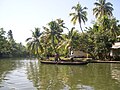 Kerala backwaters
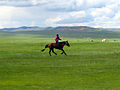 Mongolian steppe
 South China Karst
 Taman Negara, Peninsular Malaysia
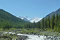 Altai Mountains
 Hunza Valley
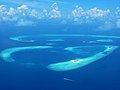 Atolls of the Maldives
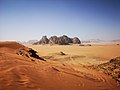 Wadi Rum in Jordan


Main regions

There are various approaches to the regional division of Asia. The following subdivision into regions is used, among others, by the United Nations Statistics Division (UNSD). This division of Asia into regions by the United Nations is done solely for statistical reasons and does not imply any assumption about political or other affiliations of countries and territories.[34]
- North Asia (Siberia)Կաղապար:Notetag
- Central Asia
- West Asia (The Middle East or Near East and part of the Caucasus)
- South Asia
- East Asia (Far East)
- Southeast Asia (East Indies and Indochina)
Climate

Asia has extremely diverse climate features. Climates range from arctic and subarctic in Siberia to tropical in southern India and Southeast Asia. It is moist across southeast sections, and dry across much of the interior. Some of the largest daily temperature ranges on Earth occur in western sections of Asia. The monsoon circulation dominates across southern and eastern sections, due to the presence of the Himalayas forcing the formation of a thermal low which draws in moisture during the summer. Southwestern sections of the continent are hot. Siberia is one of the coldest places in the Northern Hemisphere, and can act as a source of arctic air masses for North America. The most active place on Earth for tropical cyclone activity lies northeast of the Philippines and south of Japan.
Climate change
Կաղապար:Excerpt

Asia has the largest continental economy in the world by both GDP nominal and PPP values, and is the fastest growing economic region.[36] As of 2023[update], China is by far the largest economy on the continent, making up nearly half of the continent's economy by GDP nominal. It is followed by Japan, India, South Korea, Indonesia, Saudi Arabia and Turkey, which are all ranked among the top 20 largest economies both by nominal and PPP values.[37] Based on Global Office Locations 2011, Asia dominated the office locations with 4 of the top 5 being in Asia: Hong Kong, Singapore, Tokyo and Seoul. Around 68 percent of international firms have an office in Hong Kong.[38]
In the late 1990s and early 2000s, the economy of China[39] had an average annual growth rate of more than 8%. According to economic historian Angus Maddison, India had the world's largest economy during 1000 BCE and 1 CE. India was the largest economy in the world for most of the two millennia from the 1st until 19th century, contributing 25% of the world's industrial output.[40][41][42][43] China was the largest and most advanced economy on earth for much of recorded history and shared the mantle with India.[44][8][45] For several decades in the late twentieth century Japan was the largest economy in Asia and second-largest of any single nation in the world, after surpassing the Soviet Union (measured in net material product) in 1990 and Germany in 1968. (NB: A number of supernational economies are larger, such as the European Union (EU), the North American Free Trade Agreement (NAFTA) or APEC). This ended in 2010 when China overtook Japan to become the world's second largest economy. It is forecasted that India will overtake Japan in terms of nominal GDP by 2027.[36]
In the late 1980s and early 1990s, Japan's GDP by currency exchange rates was almost as large as that of the rest of Asia combined.[36] In 1995, Japan's economy nearly equaled that of the US as the largest economy in the world for a day, after the Japanese currency reached a record high of 79 yen/US$. Economic growth in Asia since World War II to the 1990s had been concentrated in Japan as well as the four regions of South Korea, Taiwan, Hong Kong and Singapore located in the Pacific Rim, known as the Asian tigers, which are now all considered developed economies, having among the highest GDP per capita in Asia.[46][36]

Asia is the largest continent in the world by a considerable margin, and it is rich in natural resources, such as petroleum, forests, fish, water, rice, copper and silver. Manufacturing in Asia has traditionally been strongest in East and Southeast Asia, particularly in China, Taiwan, South Korea, Japan, India, the Philippines, and Singapore. Japan and South Korea continue to dominate in the area of multinational corporations, but increasingly the PRC and India are making significant inroads. Many companies from Europe, North America, South Korea and Japan have operations in Asia's developing countries to take advantage of its abundant supply of cheap labour and relatively developed infrastructure.[47][48]
According to Citigroup in 2011, 9 of 11 Global Growth Generators countries came from Asia driven by population and income growth. They are Bangladesh, China, India, Indonesia, Iraq, Mongolia, the Philippines, Sri Lanka and Vietnam.[49] Asia has three main financial centers: Hong Kong, Tokyo and Singapore. Call centers and business process outsourcing (BPOs) are becoming major employers in India and the Philippines due to the availability of a large pool of highly skilled, English-speaking workers. The increased use of outsourcing has assisted the rise of India and the China as financial centers. Due to its large and extremely competitive information technology industry, India has become a major hub for outsourcing.[50]
Trade between Asian countries and countries on other continents is largely carried out on the sea routes that are important for Asia. Individual main routes have emerged from this. The main route leads from the Chinese coast south via Hanoi to Jakarta, Singapore and Kuala Lumpur through the Strait of Malacca via the Sri Lankan Colombo to the southern tip of India via Malé to East Africa Mombasa, from there to Djibouti, then through the Red Sea over the Suez Canal into Mediterranean, there via Haifa, Istanbul and Athens to the upper Adriatic to the northern Italian hub of Trieste with its rail connections to Central and Eastern Europe or further to Barcelona and around Spain and France to the European northern ports. A far smaller part of the goods traffic runs via South Africa to Europe. A particularly significant part of the Asian goods traffic is carried out across the Pacific towards Los Angeles and Long Beach. In contrast to the sea routes, the Silk Road via the land route to Europe is on the one hand still under construction and on the other hand is much smaller in terms of scope. Intra-Asian trade, including sea trade, is growing rapidly.[51][52][53][54][55][56][57][58]
In 2010, Asia had 3.3 million millionaires (people with net worth over US$1 million excluding their homes), slightly below North America with 3.4 million millionaires. In 2011, Asia topped Europe in number of millionaires.[59] Citigroup in The Wealth Report 2012 stated that Asian centa-millionaire overtook North America's wealth for the first time as the world's "economic center of gravity" continued moving east. At the end of 2011, there were 18,000 Asian people mainly in Southeast Asia, China and Japan who have at least $100 million in disposable assets, while North America with 17,000 people and Western Europe with 14,000 people.[60]
| Rank | Country | GDP (nominal, Peak Year) millions of USD |
Peak Year |
|---|---|---|---|
| 1 | Կաղապար:Country data China | 18,532,633 | 2024 |
| 2 | 6,272,363 | 2012 | |
| 3 | Կաղապար:Country data India | 3,937,011 | 2024 |
| 4 | Կաղապար:Country data Russia[62] | 2,292,470 | 2013 |
| 5 | Կաղապար:Country data South Korea | 1,818,432 | 2021 |
| 6 | Կաղապար:Country data Indonesia | 1,475,690 | 2024 |
| 7 | Կաղապար:Country data Turkey | 1,113,561 | 2024 |
| 8 | Կաղապար:Country data Saudi Arabia | 1,108,572 | 2022 |
| 9 | Կաղապար:Country data Taiwan | 802,958 | 2024 |
| 10 | Կաղապար:Country data Iran[63] | 644,036 | 2012 |
| Rank | Country | GDP (PPP, Peak Year) millions of USD |
Peak Year |
|---|---|---|---|
| 1 | Կաղապար:Country data China | 35,291,015 | 2024 |
| 2 | Կաղապար:Country data India | 14,594,460 | 2024 |
| 3 | 6,720,962 | 2024 | |
| 4 | Կաղապար:Country data Russia[64] | 6,452,309 | 2023 |
| 5 | Կաղապար:Country data Indonesia | 4,720,542 | 2024 |
| 6 | Կաղապար:Country data Turkey | 3,831,533 | 2024 |
| 7 | Կաղապար:Country data South Korea | 3,057,995 | 2024 |
| 8 | Կաղապար:Country data Saudi Arabia | 2,354,392 | 2024 |
| 9 | Կաղապար:Country data Egypt | 2,120,933 | 2023 |
| 10 | Կաղապար:Country data Iran | 1,854,845 | 2024 |

Տես նաև Tourism in Asia և Transport in Asia կատեգորիաները:
With growing Regional Tourism with domination of Chinese visitors, MasterCard has released Global Destination Cities Index 2013 with 10 of 20 are dominated by Asia and Pacific Region Cities and also for the first time a city of a country from Asia (Bangkok) set in the top-ranked with 15.98 million international visitors.[65]


Some of the events pivotal in Asia related to the relationship with the outside world in the post-Second World War were:
- The Partition of India (1947):
Led to the creation of India and Pakistan, shaping the political landscape in South Asia.
- The Indo-Pakistani War of 1947–1948:
Fought over the princely state of Jammu and Kashmir, setting the stage for future conflicts.
- The Chinese Civil War (1927–1949):
Culminated in the establishment of the People's Republic of China under the Communist Party.
- The Korean War (1950–1953):
Involved international forces and led to the division of the Korean Peninsula.
- The First Indochina War (1946–1954):
Ended with the defeat of French colonial forces and the partition of Vietnam.
- The Vietnam War (1955–1975):
A protracted conflict with significant global implications, especially during the Cold War.
- The Bangladesh Liberation War (1971):
India helped East Pakistan become independent, with Cold War ramifications.
- The Sino-Vietnamese War (1979):
Conflict between China and Vietnam following Vietnam's invasion of Cambodia.
- The Indonesian occupation of East Timor (1975–1999):
Involved Indonesia's annexation and subsequent independence through a UN-backed referendum.
- The Soviet–Afghan War (1979–1989):
Soviet intervention in Afghanistan, contributing to the rise of the mujahideen.
- The Iran–Iraq War (1980–1988):
Long-lasting conflict with regional and international implications.
- The Gulf War (1990–1991):
Resulted from Iraq's invasion of Kuwait, with international intervention.
- The Dissolution of the Soviet Union (1991):
Marked the end of the Cold War and the emergence of independent states.
- The War in Afghanistan (2001–2021):
U.S.-led intervention post-9/11 with long-lasting consequences.
- The Iraq War (2003–2011):
Led to the overthrow of Saddam Hussein and subsequent instability.
- The Arab Spring (2010–2012):
Series of uprisings and protests across the Arab world, influencing regional dynamics.
- The Syrian Civil War (2011–present):
Ongoing conflict with widespread humanitarian implications.

Wikiwand in your browser!
Seamless Wikipedia browsing. On steroids.
Every time you click a link to Wikipedia, Wiktionary or Wikiquote in your browser's search results, it will show the modern Wikiwand interface.
Wikiwand extension is a five stars, simple, with minimum permission required to keep your browsing private, safe and transparent.