File:OttomanEmpireIn1683_ar.png
From Wikipedia, the free encyclopedia
Mezinahiya vê pêşdîtinê: 637 × 599 pîksel. Resolusyonên din: 255 × 240 pîksel | 510 × 480 pîksel | 816 × 768 pîksel | 1088 × 1024 pîksel | 1966 × 1850 pîksel.
Dosyeya orjînal (1966 × 1850 pixel, mezinbûnê data: 379 KB, MIME-typ: image/png)
| Ev pel ji Wikimedia Commonsê ye. Agahdariya li ser rûpela danasîna pelê li jêr tê nîşandan. |

|
This map image could be re-created using vector graphics as an SVG file. This has several advantages; see Commons:Media for cleanup for more information. If an SVG form of this image is available, please upload it and afterwards replace this template with
{{vector version available|new image name}}.
It is recommended to name the SVG file “OttomanEmpireIn1683 ar.svg”—then the template Vector version available (or Vva) does not need the new image name parameter. |
| DanasînOttomanEmpireIn1683 ar.png |
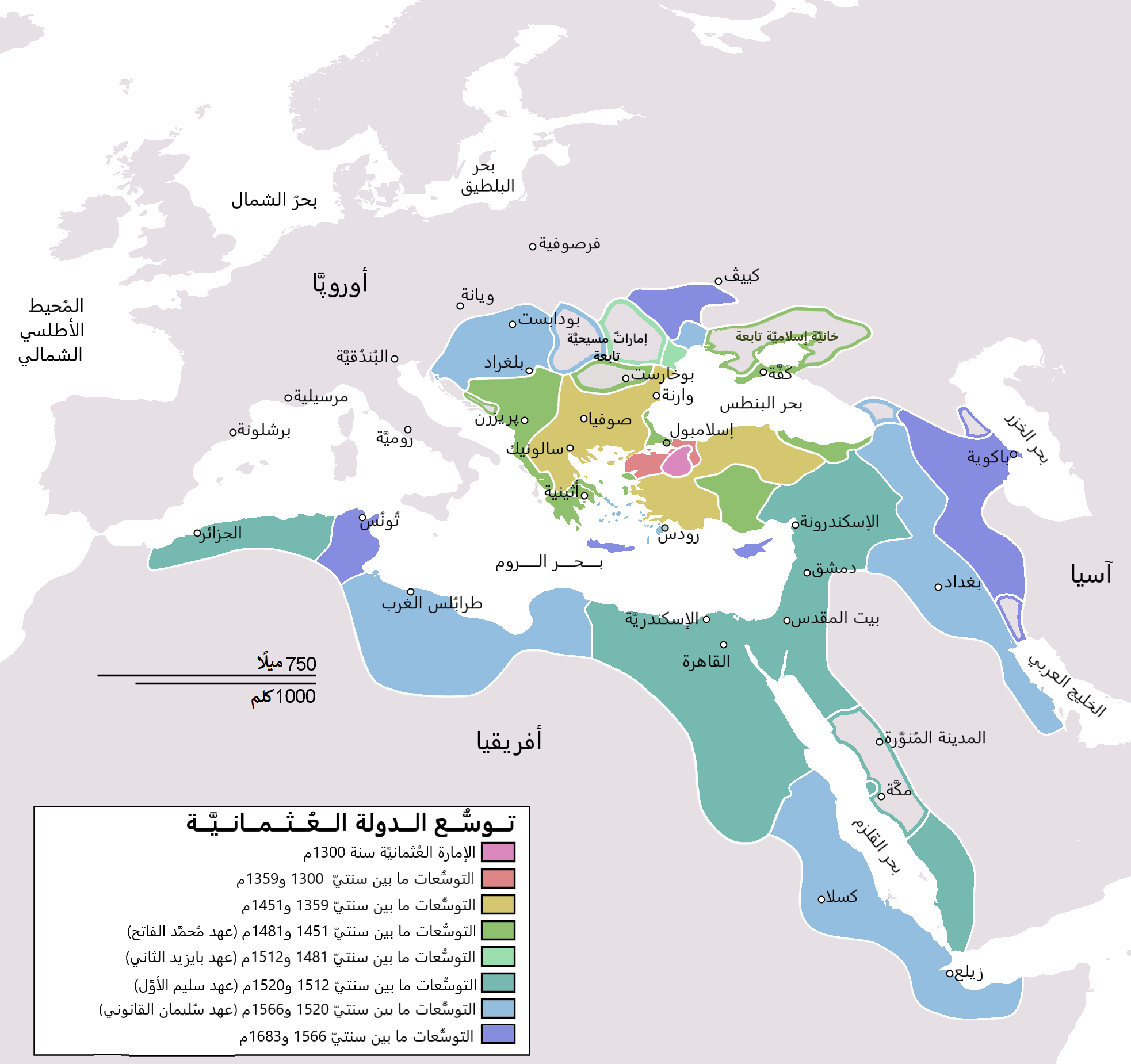
English: Map depicting the Ottoman Empire at its greatest extent, in 1683. Türkçe: Osmanlı İmparatorluğu en geniş sınırları (1683) |
| Dîrok | (UTC) |
| Çavkanî | |
| Xwedî |
|
| Guhartoyên din |
[biguhêre]
|


| Ew wêneyekî guhertî ye, li ser wêneyê orjînal guhertin hatiye çêkirin û ev pêk hatiye. Guhertinên hatine çêkirin: translated to arabic.Tu dikarî li OttomanEmpireIn1683.png wêneyê orjînal bibînî. Guhertinên wêne ji aliyê Bassem ve hatine çêkirin.
|
I, the copyright holder of this work, hereby publish it under the following license:
| Public domainPublic domainfalsefalse |
| I, the copyright holder of this work, release this work into the public domain. This applies worldwide. In some countries this may not be legally possible; if so: I grant anyone the right to use this work for any purpose, without any conditions, unless such conditions are required by law. |
Original upload log
This image is a derivative work of the following images:
- File:OttomanEmpireIn1683.png licensed with PD-self
- 2010-12-10T23:11:12Z Lambiam 1966x1850 (347599 Bytes) Scale indicator more up to actual scale
- 2010-11-16T18:53:38Z Hamelin de Guettelet 1966x1850 (375469 Bytes) {{Information |Description= Rhodes et autres îles ne sont prises aux Hospitaliers que le 1 janvier 1523 |Source={{own}} |Date=16 novembre 2010 |Author=[[User:Hamelin de Guettelet|Hamelin de Guettelet]] |Permission= |other_ve
- 2010-04-01T10:40:16Z Nedim Ardoğa 1966x1850 (334406 Bytes) Reverted to version as of 07:37, 10 March 2010
- 2010-03-31T12:11:05Z Bahramm 2 637x599 (168664 Bytes) Reverted to version as of 14:12, 1 March 2010
- 2010-03-10T07:37:04Z Nedim Ardoğa 1966x1850 (334406 Bytes) Reverted to version as of 20:35, 21 February 2010
- 2010-03-01T14:12:01Z Bahramm 2 637x599 (168664 Bytes) Reverted to version as of 18:51, 24 January 2010
- 2010-02-21T20:35:06Z Nedim Ardoğa 1966x1850 (334406 Bytes) Reverted to version as of 15:12, 26 March 2007
- 2010-01-24T18:51:26Z Persia2099 637x599 (168664 Bytes) Minor Update
- 2007-03-26T15:12:25Z AtilimGunesBaydin 1966x1850 (334406 Bytes) Updated Ionian Islands.
- 2007-03-15T01:25:07Z Stevanb 1966x1850 (310597 Bytes) Corrected some error. Very important (historical) Ottoman "city" in Balkan area is Prizren - on the map marked as Kosovo. Kosovo is region, Prizren is town (Ottoman "city").
- 2007-02-25T16:28:59Z AtilimGunesBaydin 1966x1850 (334954 Bytes) Minor update.
- 2007-02-18T02:34:25Z AtilimGunesBaydin 1966x1850 (335164 Bytes) Update territories, some city locations and labels.
- 2007-02-14T23:50:38Z AtilimGunesBaydin 1940x1500 (313464 Bytes) Minor fixes, updated some borders and the color scheme.
- 2006-12-23T00:55:59Z AtilimGunesBaydin 1684x1348 (289614 Bytes) Added more labels.
- 2006-12-21T17:47:33Z AtilimGunesBaydin 1684x1347 (249515 Bytes) {{Information |Description=Map depicting the [[:en:Ottoman Empire|Ottoman Empire]] at its greatest extent, in 1683. |Source=Self drawn, based on information mainly compiled from [[:Image:Ottoman 1683.png]], [http://fs.hunting
Uploaded with derivativeFX
Captions
Add a one-line explanation of what this file represents
Items portrayed in this file
motîv Kurdish (Latin script) (transliterated)
rewşa mafê telîfê Kurdish (Latin script) (transliterated)
destûr Kurdish (Latin script) (transliterated)
media type îngilîzî
image/png
Dîroka daneyê
Ji bo dîtina guhartoya wê demê bişkoka dîrokê bitikîne.
| Dîrok/Katjimêr | Wêneyê biçûk | Mezinahî | Bikarhêner | Şirove | |
|---|---|---|---|---|---|
| niha | 19:06, 4 çiriya paşîn 2021 | | 1966 x 1850 (379 KB) | باسم | Fixed Several mistakes - تصويب أخطاءٌ عدَّة |
| 19:54, 17 tîrmeh 2015 |  | 1966 x 1850 (431 KB) | باسم | Better Version - نسخة أفضل | |
| 19:58, 1 kanûna paşîn 2011 |  | 637 x 599 (105 KB) | باسم | {{Information |Description={{en|Map depicting the Ottoman Empire at its greatest extent, in 1683.}} {{tr|Osmanlı İmparatorluğu en geniş sınırları (1683)}} |Source=*[[:File:OttomanEmpireIn1683. |
Bikaranîna pelê
Rûpelekî ku ji vê dosyeyê bi kar tîne nîne.
Bikaranîna gerdûnî ya pelê
Ev wîkiyên di rêzê de vê pelê bi kar tînin:
- Bikaranîna di ar.wikipedia.org de
- الدولة العثمانية
- تركيا
- سليمان القانوني
- أهل السنة والجماعة
- غامد
- تاريخ ليبيا
- أتراك
- ترك
- عثمانية جديدة
- قائمة سلاطين الدولة العثمانية
- مستخدم:منصورالواقدي/ملعب
- الأقليات التركية في الدولة العثمانية السابقة
- الدولة العثمانية في شبه الجزيرة العربية
- الحرب العثمانية الصفوية (1578–1590)
- الحرب العثمانية الصفوية (1603–1618)
- تاريخ الدولة العثمانية
- مرحلة ركود الدولة العثمانية
- قائمة أكبر الإمبراطوريات
- مستخدم:منصورالواقدي/مسودة
- التسلسل الزمني لتاريخ الشرق الأوسط
- شجرة العائلة العثمانية
- تاريخ منطقة البحر المتوسط
- إمبراطوريات الشرق الأوسط
- قائمة القوى العظمى الحديثة
- ولاية (هيمنة)
- مجتمعات تركية
- Bikaranîna di ar.wikiquote.org de
- Bikaranîna di arz.wikipedia.org de
- Bikaranîna di azb.wikipedia.org de
- Bikaranîna di pnb.wikipedia.org de
- Bikaranîna di ur.wikipedia.org de
Daneyên meta
Dosye zêdetir agahiyan dihewîne, mihtemelen ji kamera an skennira dijîtal hatine ku ji bo çêkirin an dîjîtalîzekirina wan hatine bikaranîn.
Ger dosye ji halê xwe yê eslî hatibe guhartin, dibe ku hin detay bi temamî neyên xuya li ser dosyeya guhartî.
| Averûtiya asoyî | 37,79 dpc |
|---|---|
| Averûtiya stûnî | 37,79 dpc |
Ji "https://ku.wikipedia.org/wiki/Wêne:OttomanEmpireIn1683_ar.png" hatiye standin.