File:Czechoslovakia_I.png
From Wikipedia, the free encyclopedia
Groutde van disse weadergåve: 800 × 364 bealdpunten. Andere resolutys: 320 × 146 bealdpunten | 640 × 291 bealdpunten | 1.128 × 513 bealdpunten.
Oorsprungelik bestand (1.128 × 513 bealdpunten, bestandsgroutde: 66 kB, MIME-type: image/png)
Dit bestand kümt van Wikimedia Commons en kan ouk in andere projekten gebruked weasen. De syde mid de beskryving van et bestand steyt hyrunder.
| BeskryvingCzechoslovakia I.png |
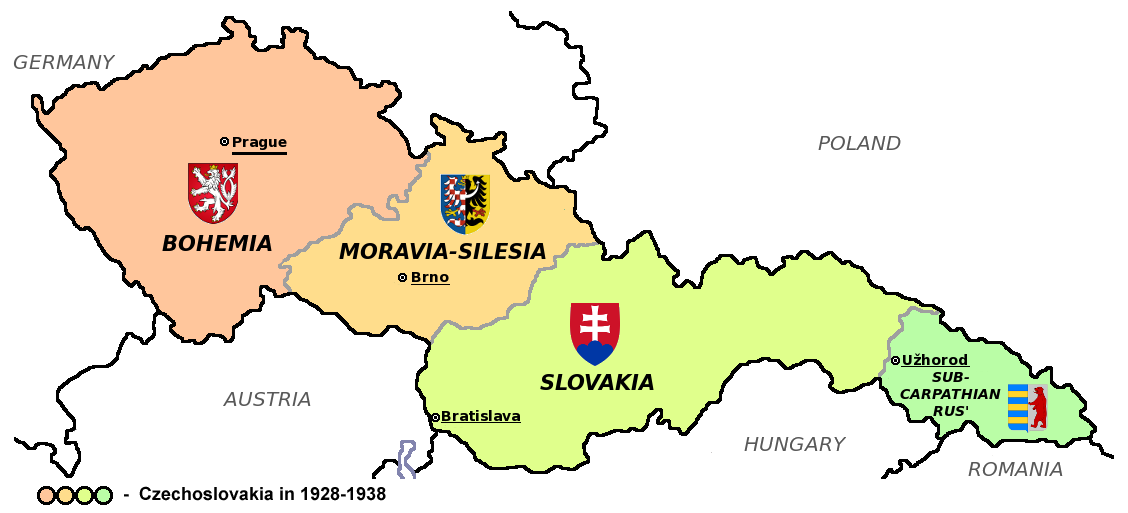
Čeština: Zemská mapa Československa v letech 1928 až 1938 s vyznačenými zemskými hlavními městy a znaky jednotlivých zemí English: Maps of Czechoslovakia in 1928-1938 with marked borders of all four Czechoslovak countries and their coats of arms and regional capital cities
Based on Image:Czechoslovakia_COA_medium.svg. * |
| Dåtum | (UTC) |
| Bron | |
| Autöör | |
| Aandere versies |
Derivative works of this file: |
| Dit is een geretoucheerde foto, wat betekent dat de originele versie digitaal aangepast is. Aanpassingen: Simplified map. Het origineel kan hier bekeken worden: CarpathianRutheniaCoA.svg. Aanpassingen gedaan door Millenium187.
|
Dit bestand valt under de Creative Commons-licensy Naamsvermelding-Lyke deylen 3.0 neet porteerd
- Jy möäget:
- üm te deylen – et wark kopieren, verspreiden en döärgeaven
- üm te hermengen – et wark anpassen
- Under de volgende vöärwaerden:
- naamsvermelding – Jy müttet up en nette manere an naamsvermelding doon, en verwysing nå de licensy geaven en angeaven of der anpassingen dån bint. Jy möäget dit up elke readelike manere doon, mär neet up sou'n manere dat et de indrük wekt dat de lincensyholder juw wark understöänt of juw gebruuk van syn wark.
- lyke deylen – As jy materiaal menget, veranderet, of derup voordbouwet, dan müt jy juw bydragen verspreiden under deselvde of een vergelykbåre licensy as de oorsprungelike.
Oorspronkelik logboek mit nieje bestaanden
This image is a derivative work of the following images:
- File:Czechoslovakia01.png licensed with PD-self
- 2011-05-19T10:54:48Z PANONIAN 1128x513 (64020 Bytes) minor change, marked provincial capitals
- 2011-05-17T09:53:27Z PANONIAN 1128x513 (63994 Bytes) Reverted to version as of 10:38, 24 April 2011 - because this is map of Czechoslovakia and it was capital of Czechoslovakia
- 2011-05-17T05:07:38Z Millenium187 1128x513 (56086 Bytes) Why was Prague underlined and Vienna, Brno, Bratislava and other capital cities were not? -- corrected
- 2011-04-24T10:38:30Z PANONIAN 1128x513 (63994 Bytes) few corrections
- 2011-04-23T11:31:49Z PANONIAN 1128x509 (62348 Bytes) improved version
- 2008-12-20T20:58:14Z Kirk 1100x497 (80038 Bytes) {{Information |Description= |Source= |Date= |Author= |Permission= |other_versions= }}
- 2006-12-28T16:11:35Z Electionworld 1100x497 (92110 Bytes) {{ew|en|PANONIAN}} Map of {{link|Czechoslovakia}} (self made) Note: The provinces shown on the map were introduced by Act No. 125/1927 Zb. and became effective in 1928. {{PD-self}} [[Category:Maps of Czechoslovakia]] [[Cat
- File:Small_coat_of_arms_of_the_Czech_Republic2.png licensed with PD-self
- 2006-07-18T15:34:18Z Poznaniak 486x594 (126651 Bytes) {{Information |Description=Godło Czech |Source=własna praca |Date=18.07.2006 |Author=[[:user:Poznaniak|Poznaniak]] |Permission= }}
- File:Moravia-Silesia.png licensed with PD-self
- 2010-07-25T21:44:29Z RgC 490x600 (65918 Bytes) {{Information |Description={{en|1=Joint of coat of arms of Moravia and Silesia.}} |Source={{own}} |Author=[[User:RgC|RgC]] |Date=2010-07-25 |Permission= |other_versions= }} [[Category:User page images]]
- File:Coat_of_arms_of_Slovakia.svg licensed with Cc-by-sa-3.0-migrated, GFDL
- 2006-06-06T21:41:47Z Tlusťa 400x500 (4623 Bytes) ==Summary== {{Information |Description={{en|Coat of arms of the [[Slovakia]].}} {{cs|Znak [[:cs:Slovensko|Slovenska]].}} |Source= |Date= |Author=[[User:Tlusťa|Tlusťa]] |Permission= |other_versions= }} ==Licensing == {{GFDL
- File:CarpathianRutheniaCoA.svg licensed with Cc-pd-mark-footer, PD-old
- 2007-06-01T16:53:20Z DDima 325x394 (27235 Bytes) fix colors
- 2006-11-08T06:35:05Z Happenstance 325x394 (27214 Bytes) created
Uploaded with derivativeFX
| Annotations InfoField | This image is annotated: View the annotations at Commons |
426
165
76
76
1128
513
Wrong coat of arms (violation of WP:NOR) – Moravian-Silesian Province had CoA composed of double shield, placed side by side (one with Moravian and one with Silesian eagle)
Bijschriften
Beschrijf in één regel wat dit bestand voorstelt
Items getoond in dit bestand
beeldt af Nederlands
auteursrechtenstatus Nederlands
auteursrechtelijk beschermd Nederlands
licentie Nederlands
datum van oprichting of creatie Nederlands
12 aug 2011
MIME-type Nederlands
image/png
checksum Nederlands
196c82b4bea76f59cd4e74d855e6f7b5162451a4
datagrootte Nederlands
67.684 byte
hoogte Nederlands
513 pixel
breedte Nederlands
1.128 pixel
Bestandsgeskydenisse
Klik up een datum/tyd üm et bestand te seen so as et destyds was.
| Datum/tyd | Miniatuurafbealding | Groutde | Gebruker | Kommentaar | |
|---|---|---|---|---|---|
| aktueel | 20:40, 12 aug 2011 | | 1.128 × 513 (66 kB) | Millenium187 | {{Information |Description={{cs|Zemská mapa Československa v letech 1928 až 1938 s vyznačenými zemskými hlavními městy a znaky jednotlivých zemí}} {{en|Maps of Czechoslovakia in 1928-1938 with marked borders of all four Czechoslovak countries a |
Bestandsgebruuk
Geen enkele syde gebruukt dit bestand.
Globaal bestandsgebruuk
De volgende andere wikis gebruken dit bestand:
- Gebruuk up azb.wikipedia.org
- Gebruuk up az.wikipedia.org
- Gebruuk up bn.wikipedia.org
- Gebruuk up da.wikipedia.org
- Gebruuk up de.wikipedia.org
- Gebruuk up el.wikipedia.org
- Gebruuk up en.wikipedia.org
- Gebruuk up es.wikipedia.org
- Gebruuk up he.wikipedia.org
- Gebruuk up io.wikipedia.org
- Gebruuk up mk.wikipedia.org
- Gebruuk up sq.wikipedia.org
- Gebruuk up te.wikipedia.org
- Gebruuk up th.wikipedia.org
- Gebruuk up tr.wikipedia.org
- Gebruuk up uk.wikipedia.org