Bestand:Famine_en_URSS_1933.jpg
Uit Wikipedia, de vrije encyclopedia
Oorspronkelijk bestand (649 × 905 pixels, bestandsgrootte: 610 kB, MIME-type: image/jpeg)
| Dit is een bestand van Wikimedia Commons. Onderstaande beschrijving komt van de beschrijving van het bestand daar. |
Beschrijving
| BeschrijvingFamine en URSS 1933.jpg |
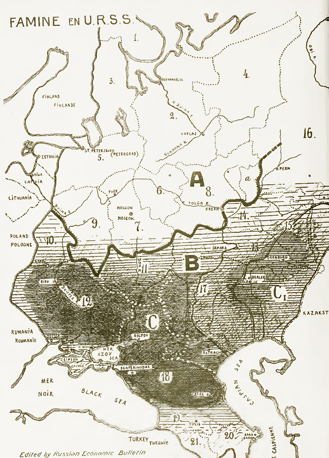
English: Famine in USSR, 1933. Areas of most disastrous famine marked with black.
Explanation of symbols on the map: A - grain-consuming regions, B - grain-producing regions. C - former land of Don, Kuban and Terek cossacks, C1 - former land of Ural and Orenburg cossacks. 1. Kola Peninsula, 2. Northern region, 3. Karelia, 4. Komi, 5. Leningrad Oblast, 6. Ivanovo Oblast, 7. Moscow Oblast, 8. Nizhny Novgorod region, 9. Western Oblast. 10. Byelorussia, 11. Central Black Earth Region, 12. Ukraine, 13. Central Volga region, 14. Tataria, 15. Bashkiria, 16. Ural region, 17. Lower Volga region, 18. North Caucasus Krai, 19. Georgia, 20. Azerbaijan, 21. Armenia.Русский: Объяснение обозначений на карте: A - районы потребляющей полосы, B - районы производящей полосы. C - бывшая территория донских, кубанских и терских казаков, C1 - бывшая территория уральских и оренбургских казаков.
1. Кольский полуостров, 2. Северный край, 3. Карелия, 4. Область Коми, 5. Ленинградская (Петербургская) область, 6. Ивановская промышленная область, 7. Московская область, 8. Нижегородский край, 9. Западная область. 10. Белоруссия, 11. Центрально-Чернозёмная область, 12. Украина, 13. Средне-Волжский край, 14. Татария, 15. Башкирия, 16. Уральская область, 17. Нижневолжский край, 18. Северо-Кавказский край, 19. Грузия, 20. Азербайджан, 21. Армения. |
|||||
| Datum | ||||||
| Bron |
1. A. Markoff "Famine in USSR" [1] 2. приложение к N 4-5 эмигрантского журнала "За рулем", август-сентябрь 1933 года. Перепечатка из Русского экономического бюллетеня, 9. [2] |
|||||
| Auteur | неизв. | |||||
| Toestemming (Hergebruik van dit bestand) |
|
|||||
| Andere versies |
|
|||||


Bijschriften
Items getoond in dit bestand
beeldt af
Bestandsgeschiedenis
Klik op een datum/tijd om het bestand te zien zoals het destijds was.
| Datum/tijd | Miniatuur | Afmetingen | Gebruiker | Opmerking | |
|---|---|---|---|---|---|
| huidige versie | 2 mrt 2014 13:19 | | 649 × 905 (610 kB) | Soerfm | Color, contrast |
| 16 jul 2010 11:17 |  | 649 × 905 (193 kB) | DonaldDuck | {{Information |Description=Карта главных районов голода в СССР. Чем гуще штриховка - тем сильнее размеры бедствия. Объяснение обозначений на карте:A - ра |
Bestandsgebruik
Dit bestand wordt op de volgende pagina gebruikt:
Globaal bestandsgebruik
De volgende andere wiki's gebruiken dit bestand:
- Gebruikt op az.wikipedia.org
- Gebruikt op ba.wikipedia.org
- Gebruikt op be-tarask.wikipedia.org
- Gebruikt op bg.wikipedia.org
- Gebruikt op cs.wikipedia.org
- Gebruikt op de.wikipedia.org
- Gebruikt op en.wikipedia.org
- History of Russia
- Joseph Stalin
- Soviet Union
- Collectivization in the Soviet Union
- Holodomor
- Droughts and famines in Russia and the Soviet Union
- Soviet famine of 1930–1933
- Portal:Genocide/Selected article
- Portal:Genocide/Selected article/2
- Mass killings under communist regimes
- Portal:Soviet Union
- Collective farming
- Excess mortality in the Soviet Union under Joseph Stalin
- User:Adamdead/sandbox
- Abraham Markoff
- User:BlueSwurl/sandbox
- User:Pawelboch/sandbox
- User:Vivaelcelta/Mass killings under communist regimes
- Gebruikt op en.wikiversity.org
- Gebruikt op es.wikipedia.org
- Gebruikt op et.wikipedia.org
- Gebruikt op eu.wikipedia.org
- Gebruikt op fa.wikipedia.org
- Gebruikt op fr.wikipedia.org
- Gebruikt op fy.wikipedia.org
- Gebruikt op he.wikipedia.org
Globaal gebruik van dit bestand bekijken.
Metadata
Dit bestand bevat metadata met EXIF-informatie, die door een fotocamera, scanner of fotobewerkingsprogramma toegevoegd kan zijn.
| Gebruikte software | Adobe Photoshop CS2 Windows |
|---|---|
| Oriëntatie | Normaal |
| Horizontale resolutie | 72 dpi |
| Verticale resolutie | 72 dpi |
| Tijdstip laatste bestandswijziging | 2 mrt 2014 11:25 |
| Y- en C-positionering | Gecentreerd |
| Exif-versie | 2.2 |
| Subseconden tijdstip bestandswijziging | 750 |
| Kleurruimte | sRGB |
| Afbeeldingsbreedte | 649 px |
| Afbeeldingshoogte | 905 px |
| Tijdstip digitalisering | 2 mrt 2014 12:19 |
| Datum waarop de metadata het laatst zijn bewerkt | 2 mrt 2014 12:25 |