Bestand:Map_of_The_Hotakids.png
Uit Wikipedia, de vrije encyclopedia
Map_of_The_Hotakids.png (620 × 429 pixels, bestandsgrootte: 27 kB, MIME-type: image/png)
| Dit is een bestand van Wikimedia Commons. Onderstaande beschrijving komt van de beschrijving van het bestand daar. |
Beschrijving
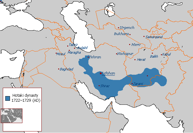
| BeschrijvingMap of The Hotakids.png |
English: Map of The Hotakids from 1722 to 1729 |
| Datum | 29 augustus 2007 (originele uploaddatum) |
| Bron |
Eigen werk, Sources consulted in the making of this map include: The Fall of the Safavi Dynasty and the Afghan Occupation of Persia by Laurence Lockhart The Afghan Occupation of Safavid Persia 1721-1729 by Willem Floor Articles from Encyclopedia Iranica History of the Wars 1721-1738 by Abraham of Erevan and translated by George A. Bournoutian The Chronicles of a Traveller: Or, A History of the Afghan Wars with Persia by Tadeusz Judas Krusiński |
| Auteur | Arab Hafez op de Engelstalige Wikipedia |
Licentie
| Public domainPublic domainfalsefalse |
| Dit werk vrijgegeven in het publieke domein door de auteur, Arab Hafez op de Engelstalige Wikipedia. Dit is wereldwijd van toepassing. In sommige landen is dit wettelijk niet mogelijk; in die gevallen geldt: Arab Hafez staat iedereen toe dit werk voor eender welk doel te gebruiken, zonder enige voorwaarden, tenzij zulke voorwaarden door de wet worden voorgeschreven.Public domainPublic domainfalsefalse |
Oorspronkelijk uploadlogboek
Verplaatst vanaf en.wikipedia naar Commons.
- 2007-08-29 21:49 Arab Hafez 620×429× (24487 bytes)
Bijschriften
Items getoond in dit bestand
beeldt af
29 aug 2007
image/png
Bestandsgeschiedenis
Klik op een datum/tijd om het bestand te zien zoals het destijds was.
| Datum/tijd | Miniatuur | Afmetingen | Gebruiker | Opmerking | |
|---|---|---|---|---|---|
| huidige versie | 17 aug 2021 15:42 | | 620 × 429 (27 kB) | Kailanmapper | Reverted to version as of 16:37, 31 July 2021 (UTC) if you would read the sources you would know its accurate |
| 15 aug 2021 23:20 |  | 620 × 429 (18 kB) | Casperti | Reverted to version as of 12:38, 31 July 2021 (UTC) Do not engage in a conflict on Wiki commons open a discussion where you get consensus for it | |
| 31 jul 2021 18:37 |  | 620 × 429 (27 kB) | Noorullah21 | Reverted to version as of 12:51, 28 July 2021 (UTC) Final edit before this traerses to an edit war, first of all, the ottoman hotak war ended 1-2 years prior to this map, this map is a 1728-1729 hotak map. 2. The old map is incredibly inaccurate, and exaggerated claims throughout, it is unsourced and a wrong map. Hence why it is being replaced with the one Kalilan made, a much more accurate map. | |
| 31 jul 2021 14:38 |  | 620 × 429 (18 kB) | Casperti | Reverted to version as of 10:58, 28 July 2021 (UTC) Against all reliable sources and consensus. Besides the Ottoman-Hotak war Is here ignored | |
| 28 jul 2021 14:51 |  | 620 × 429 (27 kB) | Kailanmapper | Reverted to version as of 03:16, 28 July 2021 (UTC) the ip addresses involved haven't even tried to address my claims after several days. Plus Wikipedia literally says that unsourced information should be challenged and removed. I initially uploaded my own work separately but it got removed countless times from those very ip adresses who are refusing to say anything | |
| 28 jul 2021 12:58 |  | 620 × 429 (18 kB) | Xerxes1985 | Reverted to version as of 02:20, 28 July 2021 (UTC)inaccurate or accurate doesn’t matter, Again, where’s your consensus for this version? Upload your own work separately if you want to | |
| 28 jul 2021 05:16 |  | 620 × 429 (27 kB) | Kailanmapper | Reverted to version as of 20:53, 27 July 2021 (UTC) again, that is inaccurate and unsourced | |
| 28 jul 2021 04:20 |  | 620 × 429 (18 kB) | Xerxes1985 | Reverted to version as of 11:10, 27 July 2021 (UTC) No consensus for this map | |
| 27 jul 2021 22:53 |  | 620 × 429 (27 kB) | Noorullah21 | The old map is inaccurate, read the talk page please. | |
| 27 jul 2021 13:10 |  | 620 × 429 (18 kB) | Mukhis125 | Reverted to version as of 08:28, 19 August 2011 (UTC) |
Bestandsgebruik
Dit bestand wordt op de volgende 2 pagina's gebruikt:
Globaal bestandsgebruik
De volgende andere wiki's gebruiken dit bestand:
- Gebruikt op ar.wikipedia.org
- Gebruikt op ast.wikipedia.org
- Gebruikt op bn.wikipedia.org
- Gebruikt op en.wikipedia.org
- Gebruikt op eo.wikipedia.org
- Gebruikt op et.wikipedia.org
- Gebruikt op fa.wikipedia.org
- Gebruikt op fi.wikipedia.org
- Gebruikt op he.wikipedia.org
- Gebruikt op hr.wikipedia.org
- Gebruikt op id.wikipedia.org
- Gebruikt op it.wikipedia.org
- Gebruikt op no.wikipedia.org
- Gebruikt op pnb.wikipedia.org
- Gebruikt op ps.wikipedia.org
- Gebruikt op pt.wikipedia.org
- Gebruikt op ru.wikipedia.org
- Gebruikt op sh.wikipedia.org
- Gebruikt op sv.wikipedia.org
- Gebruikt op tg.wikipedia.org
- Gebruikt op tr.wikipedia.org
- Gebruikt op uk.wikipedia.org
- Gebruikt op www.wikidata.org
- Gebruikt op zh.wikipedia.org
Metadata
Dit bestand bevat metadata met EXIF-informatie, die door een fotocamera, scanner of fotobewerkingsprogramma toegevoegd kan zijn.
| Horizontale resolutie | 28,35 dpc |
|---|---|
| Verticale resolutie | 28,35 dpc |
| Tijdstip laatste bestandswijziging | 26 jul 2021 02:58 |