Bestand:Southern_ocean_gravity_hg.png
Uit Wikipedia, de vrije encyclopedia
Grootte van deze voorvertoning: 800 × 558 pixels. Andere resoluties: 320 × 223 pixels | 640 × 447 pixels | 1.024 × 715 pixels | 1.155 × 806 pixels.
Oorspronkelijk bestand (1.155 × 806 pixels, bestandsgrootte: 1,18 MB, MIME-type: image/png)
| Dit is een bestand van Wikimedia Commons. Onderstaande beschrijving komt van de beschrijving van het bestand daar. |
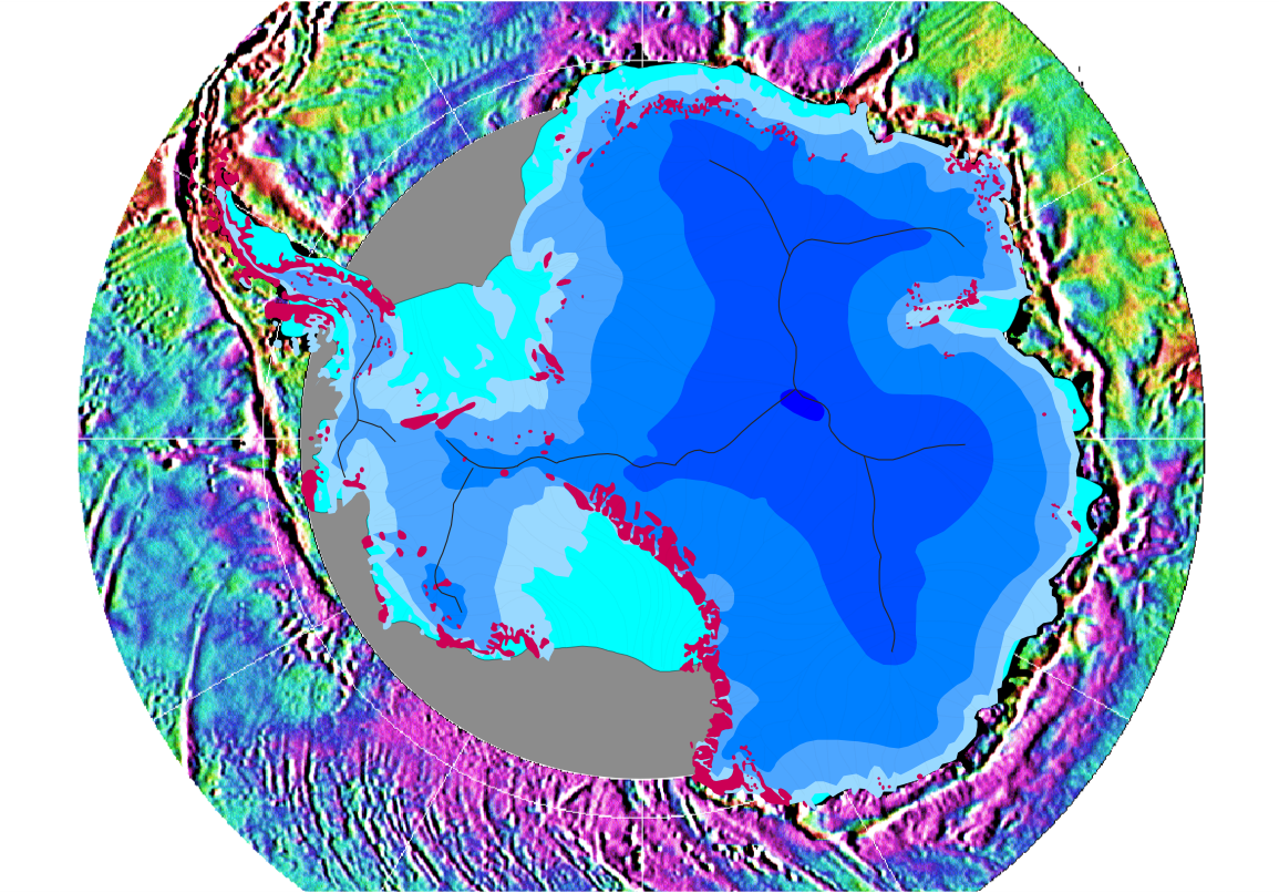
| BeschrijvingSouthern ocean gravity hg.png |
English: Gravity map of the Southern Ocean around the Antarctic continent
This gravity field was computed from sea-surface height measurements collected by the US Navy GEOSAT altimeter between March, 1985, and January, 1990. The high density GEOSAT Geodetic Mission data that lie south of 30 deg. S were declassified by the Navy in May of 1992 and contribute most of the fine-scale gravity information. The Antarctic continent itself is shaded in blue depending on the thickness of the ice sheet (blue shades in steps of 1000 m); light blue is shelf ice; gray lines are the major ice devides; pink spots are parts of the continent which are not covered by ice; gray areas have no data. Français : Carte gravimétrique de l'océan Austral et du continent antarctique Ce champ de gravité a été calculé à partir de mesures de hauteur des eaux de surface recueillies par l'altimètre de l'US Navy GEOSAT de Mars 1985 à Janvier 1990. Les données récolées par la mission "high density GEOSAT Geodetic Mission data" ont été déclassifiées par la Marine, en mai 1992 et fournissent la plupart des informations sur la gravité à petite échelle. Le continent antarctique lui-même est coloré en bleu selon l'épaisseur de la calotte glaciaire (Chaque nuances de bleu correspond à une étape de 1000 m) ; lignes grises matérialisent les bassins versants de glace; les taches roses sont les parties du continent qui ne sont pas couvertes par la glace, les zones grises sont celles pour lesquelles on manque de données |
| Datum | |
| Bron | Antarctic continent: own work; gravity field: NOAA/NGDC (Marks, McAdoo & Smith) |
| Auteur | Hannes Grobe, AWI |
| Toestemming (Hergebruik van dit bestand) |
Own work and public domain of NOAA |
| Andere versies | Gravity data are available from the National Oceanographic Data Center, NOAA (NODC Env. Bull. 93-1); the digital gravity data shown in this image are available from the National Geophysical Data Center on the Global Relief CD-ROM (NGDC Data Announcement 93-MGG-01). See the GIF image at NGDC. |
| Public domainPublic domainfalsefalse |
Deze afbeelding is in het publiek domein omdat het materiaal bevat dat oorspronkelijk van de National Oceanic and Atmospheric Administration kwam in de Verenigde Staten en genomen of gemaakt is tijdens de officiële werkzaamheden van een werknemer.
العربية ∙ čeština ∙ Deutsch ∙ Zazaki ∙ English ∙ español ∙ eesti ∙ suomi ∙ français ∙ hrvatski ∙ magyar ∙ italiano ∙ 日本語 ∙ 한국어 ∙ македонски ∙ മലയാളം ∙ Plattdüütsch ∙ Nederlands ∙ polski ∙ português ∙ română ∙ русский ∙ sicilianu ∙ slovenščina ∙ Türkçe ∙ Tiếng Việt ∙ 简体中文 ∙ 繁體中文 ∙ +/− |
Bijschriften
Beschrijf in één regel wat dit bestand voorstelt
Items getoond in dit bestand
beeldt af
8 aug 2006
Bestandsgeschiedenis
Klik op een datum/tijd om het bestand te zien zoals het destijds was.
| Datum/tijd | Miniatuur | Afmetingen | Gebruiker | Opmerking | |
|---|---|---|---|---|---|
| huidige versie | 12 aug 2006 23:53 | | 1.155 × 806 (1,18 MB) | Hgrobe | {{Information| |Description=Gravity map of the Southern Ocean around the Antarctic continent |Source=own work |Date=2006-08-08 |Author=~~~~ |Permission=Own work, share alike, attribution required (Creative Commons CC-BY-SA-2.5) |other_versions= }} {{self |
Bestandsgebruik
Dit bestand wordt op de volgende 2 pagina's gebruikt:
Globaal bestandsgebruik
De volgende andere wiki's gebruiken dit bestand:
- Gebruikt op als.wikipedia.org
- Gebruikt op ar.wikipedia.org
- Gebruikt op bg.wikipedia.org
- Gebruikt op ca.wikipedia.org
- Gebruikt op ckb.wikipedia.org
- Gebruikt op crh.wikipedia.org
- Gebruikt op de.wikipedia.org
- Gebruikt op el.wikipedia.org
- Gebruikt op en.wikipedia.org
- Gebruikt op es.wikipedia.org
- Gebruikt op fa.wikipedia.org
- Gebruikt op fr.wikipedia.org
- Gebruikt op fy.wikipedia.org
- Gebruikt op hr.wikipedia.org
- Gebruikt op hu.wikipedia.org
- Gebruikt op ja.wikipedia.org
- Gebruikt op nn.wikipedia.org
- Gebruikt op no.wikipedia.org
- Gebruikt op pl.wikipedia.org
- Gebruikt op ro.wikipedia.org
- Gebruikt op sr.wikipedia.org
- Gebruikt op sv.wikipedia.org
- Gebruikt op te.wikipedia.org
- Gebruikt op tr.wikipedia.org
- Gebruikt op uk.wikipedia.org
- Gebruikt op vi.wikipedia.org
- Gebruikt op www.wikidata.org
- Gebruikt op zh.wikipedia.org
Overgenomen van "https://nl.wikipedia.org/wiki/Bestand:Southern_ocean_gravity_hg.png"