Fichier:Czechoslovakia.png
From Wikipedia, the free encyclopedia
Fichier d’origine (1 188 × 604 picséls, diminchon dech fichié: 69 kio, MIME tipe: image/png)
Ch'fichié i vient éd Wikimedia Commons. I put ète uzé pèr d’eutes prodjés. Vir l'pache édseur Commons.

|
Cette image (de type historical map) devrait être recréée dans un format vectoriel, en tant que fichier SVG. Cela offrirait plusieurs avantages : voir Commons:Media for cleanup pour plus d'informations. Si une version SVG de cette image est déjà disponible, merci de bien vouloir l'envoyer. Après cela, remplacez ce modèle par {{vector version available|nouveau nom d'image.svg}}.
|
Résumè
| DécripchonCzechoslovakia.png |
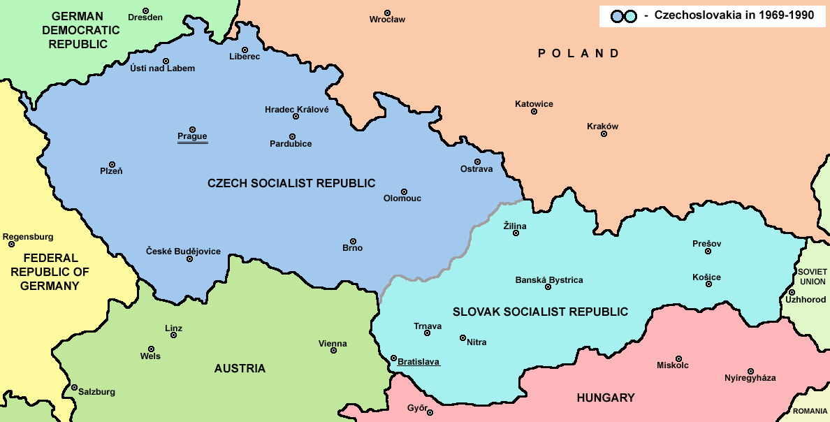
English: Map of Czechoslovakia in 1969-1990 |
||
| Source | Traval parsonnel | ||
| Auteu | PANONIAN | ||
| Autres versions |
|


Licince
| Public domainPublic domainfalsefalse |
| |
Cette image a été (ou est ici-même) mise à disposition dans le domaine public par son auteur, PANONIAN dans le projet Wikimedia Commons. Ceci s'applique partout dans le monde. Au cas où cela n'est pas possible légalement : |
References
Main reference:
- Map is created according to this external source: http://www.tcnj.edu/~guhr2/images/czechoslovakia.jpg archive copy at the Wayback Machine
Secondary references with similar maps:
- http://1.bp.blogspot.com/_Qe1wgxDiEdU/TGti_qWpeYI/AAAAAAAABo0/sSqAfIpQMuU/s1600/1213M_CS.gif
- https://jspivey.wikispaces.com/file/view/T010895A.gif/34419939/T010895A.gif
- http://media.web.britannica.com/eb-media/84/105684-050-0D8412E3.gif archive copy at the Wayback Machine
- http://www.gatheringofisrael.com/atlas/europe/slavic/CS_prague.gif
- http://collections.lib.uwm.edu/agsmap/images/lg/DSCN1455.jpg[lien mort]
- http://leccos.com/pics/pic/ceskoslovensko-_mapa_1950.jpg archive copy at the Wayback Machine
- http://www.math.sk/knor/GIF/mapa.gif
- http://ckpaji.sweb.cz/ceskoslovensko.jpg archive copy at the Wayback Machine
- http://www.power.szm.com/historia/mapa_TV_vysielacov_1978.jpg
Secondary references about Geo-political situation - published sources:
- The Times History of Europe, Times Books, London, 2002.
- Richard Overy, The Times History of the 20th Century, Times Books, London, 2004.
- The Times Atlas svjetske povijesti, Cankarjeva založba, Ljubljana - Zagreb, 1986.
- Istorijski atlas, Geokarta, Beograd, 1999.
- Školski istorijski atlas, Zavod za izdavanje udžbenika SR Srbije, Beograd, 1970.
- Povijesni atlas, Učila - Zagreb, Zagreb, 1971.
- Povijesni atlas za osnovnu školu, Kartografija - Tlos, Zagreb, 1975.
- Denis Šehić - Demir Šehić, Istorijski atlas sveta, Beograd, 2007.
Secondary reference about sizable cities:
|
|
Cette image (de type carte) devrait être recréée dans un format vectoriel, en tant que fichier SVG. Cela offrirait plusieurs avantages : voir Commons:Media for cleanup pour plus d'informations. Si une version SVG de cette image est déjà disponible, merci de bien vouloir l'envoyer. Après cela, remplacez ce modèle par {{vector version available|nouveau nom d'image.svg}}.
|
La production, l'édition ou le partage de ce fichier a été soutenu par le Budget Communautaire de Wikimédia Allemagne. Pour voir tous les fichiers concernés, consultez la catégorie Supported by Wikimedia Deutschland. العربية ∙ বাংলা ∙ Deutsch ∙ English ∙ Esperanto ∙ français ∙ magyar ∙ Bahasa Indonesia ∙ italiano ∙ 日本語 ∙ македонски ∙ മലയാളം ∙ Bahasa Melayu ∙ Nederlands ∙ português ∙ русский ∙ slovenščina ∙ svenska ∙ українська ∙ தமிழ் ∙ +/−
|
Légendes
Éléments décrits dans ce fichier
dépeint français
créé par français
Valeur sans élément de Wikidata
licence français
source du fichier français
type MIME français
image/png
somme de contrôle français
988843af23cf6b2ab48cfc10bab00f4951a2c319
taille des données français
71 058 octet
hauteur français
604 pixel
largeur français
1 188 pixel
Histoère dech fichié
Buke su eune date/heure pou vir ch'fichié conme il étoait ach momint-lo.
| Date/Tans | Tiote image | Diminsions | Uzeu | Fichié éd chés conmints | |
|---|---|---|---|---|---|
| courant | 12 ed Juillet 2022 à 14:45 | | 1 188 × 604 (69 kio) | Sebastian Wallroth | CROPPED |
| 12 ed Févrié 2017 à 17:38 |  | 1 221 × 652 (69 kio) | PANONIAN | Reverted to version as of 11:00, 24 April 2011 (UTC) - why you uploading polish version over english one? upload polish version under different filename | |
| 9 ed Févrié 2017 à 15:18 |  | 1 221 × 652 (57 kio) | Kelvin | Reverted to version as of 15:13, 9 February 2017 (UTC) | |
| 9 ed Févrié 2017 à 15:17 |  | 1 221 × 652 (69 kio) | Kelvin | Reverted to version as of 11:00, 24 April 2011 (UTC) | |
| 9 ed Févrié 2017 à 15:13 |  | 1 221 × 652 (57 kio) | Kelvin | Polish names of countries /Polskie określenia krajów | |
| 24 d'Avri 2011 à 11:00 |  | 1 221 × 652 (69 kio) | PANONIAN | correction | |
| 23 d'Avri 2011 à 10:27 |  | 1 221 × 652 (69 kio) | PANONIAN | improved version | |
| 10 ed Déchimbe 2006 à 23:31 |  | 1 200 × 624 (19 kio) | Severino666~commonswiki | Map of Czechoslovakia (self made) Category:Maps of Czechoslovakia Category:Maps of Czech history Category:Maps of the history of Slovakia Category:Maps of the history of Central Europe {{PD}} |
Usage dech fichié
L'pache d'apreu est loyée à ch'fichié-lo :
Usage global du fichier
Chés eutes wikis suivants uzette chole fichier :
- Utilisacion édseur ang.wikipedia.org
- Utilisacion édseur an.wikipedia.org
- Utilisacion édseur ar.wikipedia.org
- Utilisacion édseur azb.wikipedia.org
- Utilisacion édseur az.wikipedia.org
- Utilisacion édseur bar.wikipedia.org
- Utilisacion édseur ba.wikipedia.org
- Utilisacion édseur bcl.wikipedia.org
- Utilisacion édseur be-tarask.wikipedia.org
- Utilisacion édseur be.wikipedia.org
- Utilisacion édseur bg.wikipedia.org
- Utilisacion édseur bn.wikipedia.org
- Utilisacion édseur br.wikipedia.org
- Utilisacion édseur bs.wikipedia.org
- Utilisacion édseur ca.wikipedia.org
- Utilisacion édseur cv.wikipedia.org
- Utilisacion édseur da.wikipedia.org
- Utilisacion édseur de.wikipedia.org
- Utilisacion édseur dsb.wikipedia.org
- Utilisacion édseur el.wikipedia.org
- Utilisacion édseur en.wikipedia.org
- Czechoslovakia
- History of Slovakia
- History of Czechoslovakia (1948–1989)
- History of Czechoslovakia (1989–1992)
- Economy of communist Czechoslovakia
- History of Czechoslovakia
- Dissolution of Czechoslovakia
- Czechoslovak Socialist Republic
- Portal:Slovakia
- She Grazed Horses on Concrete
- Rugby union in Czechoslovakia
Vir davantage édseur l’utilisacion globale éd chole fichié-lo.
Metadata
Ech fichié-lo i conprinte des informacions métadatas éq ils sont suremint rajoutées par echl’apàrèl foto limérique ou ech éscanère utilisé pou l' créer.
Si ch' fichié o té canjé dpui sin étot avoyé, quéques détals peute n'poin corésponne à l’imache modifiée.
| Résolution horizontale | 28,35 pt/cm |
|---|---|
| Résolution verticale | 28,35 pt/cm |