فائل:OttomanEmpireIn1683_ar.png
From Wikipedia, the free encyclopedia
ایس وکھالے دا ناپ: ۶۳۷ × ۵۹۹ پکسلز۔ دوجے ریزولوشنز: ۲۵۵ × ۲۴۰ پکسلز | ۵۱۰ × ۴۸۰ پکسلز | ۸۱۶ × ۷۶۸ پکسلز | ۱,۰۸۸ × ۱,۰۲۴ پکسلز | ۱,۹۶۶ × ۱,۸۵۰ پکسلز ۔
اصل فائل (۱,۹۶۶ × ۱,۸۵۰ پکسلز, فائل حجم: ۳۷۹ کلوبائٹ, MIME type: image/png)
ایہ فائل Wikimedia Commons توں اے تے دوجیاں ویونتاں تے وی ورتی جاسکدی اے۔ گل بات اس دے فائل گل بات صفحہ تے تھلے دتی گئی۔

|
This map image could be re-created using vector graphics as an SVG file. This has several advantages; see Commons:Media for cleanup for more information. If an SVG form of this image is available, please upload it and afterwards replace this template with
{{vector version available|new image name}}.
It is recommended to name the SVG file “OttomanEmpireIn1683 ar.svg”—then the template Vector version available (or Vva) does not need the new image name parameter. |
| تفصیلOttomanEmpireIn1683 ar.png |
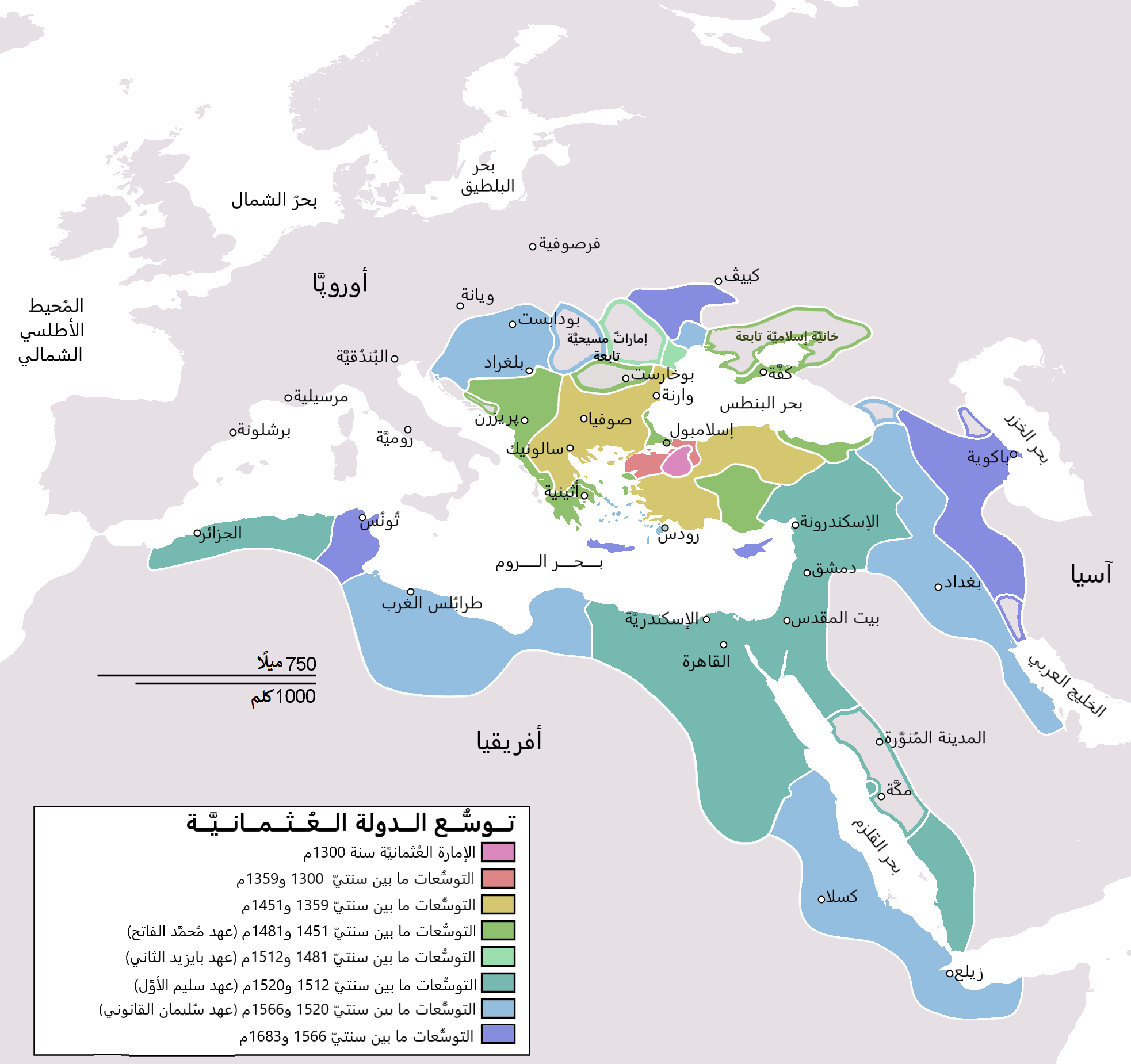
English: Map depicting the Ottoman Empire at its greatest extent, in 1683. Türkçe: Osmanlı İmparatorluğu en geniş sınırları (1683) |
| تریخ | (UTC) |
| سروت | |
| لکھاری |
|
| دوجے ورژن |
[سودھو]
|


| This is a retouched picture, which means that it has been digitally altered from its original version. Modifications: translated to arabic. The original can be viewed here: OttomanEmpireIn1683.png:
|
میں، اس کم دے کاپیرائٹ دا مالک، اس کم نوں اس لائسنس دے مطابق چھاپدا واں:
| Public domainPublic domainfalsefalse |
| میں، اس کم دے کاپیرائٹ دا مالک، اس کم نوں لوکاں واسطے دیندا واں۔ اے سارے جگ واسطے لاگو اے۔ کج ملکاں چ قانونی طور تے اے ممکن نئیں اے؛ اگر انج ای اے ے: میں ہر کسے نوں اس کم نوں کسے وی مقصد واسطے ورتن دا بغیر کسے شرط دے حق دیندا واں، اگر اوہ قانون دے خلاف نا ہوۓ۔ |
پہلا اپلوڈ دا ریکارڈ
This image is a derivative work of the following images:
- File:OttomanEmpireIn1683.png licensed with PD-self
- 2010-12-10T23:11:12Z Lambiam 1966x1850 (347599 Bytes) Scale indicator more up to actual scale
- 2010-11-16T18:53:38Z Hamelin de Guettelet 1966x1850 (375469 Bytes) {{Information |Description= Rhodes et autres îles ne sont prises aux Hospitaliers que le 1 janvier 1523 |Source={{own}} |Date=16 novembre 2010 |Author=[[User:Hamelin de Guettelet|Hamelin de Guettelet]] |Permission= |other_ve
- 2010-04-01T10:40:16Z Nedim Ardoğa 1966x1850 (334406 Bytes) Reverted to version as of 07:37, 10 March 2010
- 2010-03-31T12:11:05Z Bahramm 2 637x599 (168664 Bytes) Reverted to version as of 14:12, 1 March 2010
- 2010-03-10T07:37:04Z Nedim Ardoğa 1966x1850 (334406 Bytes) Reverted to version as of 20:35, 21 February 2010
- 2010-03-01T14:12:01Z Bahramm 2 637x599 (168664 Bytes) Reverted to version as of 18:51, 24 January 2010
- 2010-02-21T20:35:06Z Nedim Ardoğa 1966x1850 (334406 Bytes) Reverted to version as of 15:12, 26 March 2007
- 2010-01-24T18:51:26Z Persia2099 637x599 (168664 Bytes) Minor Update
- 2007-03-26T15:12:25Z AtilimGunesBaydin 1966x1850 (334406 Bytes) Updated Ionian Islands.
- 2007-03-15T01:25:07Z Stevanb 1966x1850 (310597 Bytes) Corrected some error. Very important (historical) Ottoman "city" in Balkan area is Prizren - on the map marked as Kosovo. Kosovo is region, Prizren is town (Ottoman "city").
- 2007-02-25T16:28:59Z AtilimGunesBaydin 1966x1850 (334954 Bytes) Minor update.
- 2007-02-18T02:34:25Z AtilimGunesBaydin 1966x1850 (335164 Bytes) Update territories, some city locations and labels.
- 2007-02-14T23:50:38Z AtilimGunesBaydin 1940x1500 (313464 Bytes) Minor fixes, updated some borders and the color scheme.
- 2006-12-23T00:55:59Z AtilimGunesBaydin 1684x1348 (289614 Bytes) Added more labels.
- 2006-12-21T17:47:33Z AtilimGunesBaydin 1684x1347 (249515 Bytes) {{Information |Description=Map depicting the [[:en:Ottoman Empire|Ottoman Empire]] at its greatest extent, in 1683. |Source=Self drawn, based on information mainly compiled from [[:Image:Ottoman 1683.png]], [http://fs.hunting
Uploaded with derivativeFX
Captions
Add a one-line explanation of what this file represents
Items portrayed in this file
چترن
media type English
image/png
فائل دی تریخ
فائل نو اس ویلے دی حالت وچ ویکھن واسطے تاریخ/ویلے تے کلک کرو۔
| تریخ تے ویلہ | نکی مورت | پاسے | ورتن والا | تیپّݨی کرو | |
|---|---|---|---|---|---|
| موجودہ | ۰۰:۰۶, ۵ نومبر ۲۰۲۱ | | ۱,۹۶۶ × ۱,۸۵۰ (۳۷۹ کلوبائٹ) | باسم | Fixed Several mistakes - تصويب أخطاءٌ عدَّة |
| ۰۰:۵۴, ۱۸ جولائی ۲۰۱۵ |  | ۱,۹۶۶ × ۱,۸۵۰ (۴۳۱ کلوبائٹ) | باسم | Better Version - نسخة أفضل | |
| ۰۰:۵۸, ۲ جنوری ۲۰۱۱ |  | ۶۳۷ × ۵۹۹ (۱۰۵ کلوبائٹ) | باسم | {{Information |Description={{en|Map depicting the Ottoman Empire at its greatest extent, in 1683.}} {{tr|Osmanlı İmparatorluğu en geniş sınırları (1683)}} |Source=*[[:File:OttomanEmpireIn1683. |
فائل دی ورتوں
تھلے دتے گئے 1 صفحے اس فائل نال جُڑدے نیں
فائل ویاپک ورتوں
ایہہ دوجے وکیاں ایس فائل نوں ورتدے نیں –
- ar.wikipedia.org تے ورتوں
- الدولة العثمانية
- تركيا
- سليمان القانوني
- أهل السنة والجماعة
- غامد
- تاريخ ليبيا
- أتراك
- ترك
- عثمانية جديدة
- قائمة سلاطين الدولة العثمانية
- مستخدم:منصورالواقدي/ملعب
- الأقليات التركية في الدولة العثمانية السابقة
- الدولة العثمانية في شبه الجزيرة العربية
- الحرب العثمانية الصفوية (1578–1590)
- الحرب العثمانية الصفوية (1603–1618)
- تاريخ الدولة العثمانية
- مرحلة ركود الدولة العثمانية
- قائمة أكبر الإمبراطوريات
- مستخدم:منصورالواقدي/مسودة
- التسلسل الزمني لتاريخ الشرق الأوسط
- شجرة العائلة العثمانية
- تاريخ منطقة البحر المتوسط
- إمبراطوريات الشرق الأوسط
- قائمة القوى العظمى الحديثة
- ولاية (هيمنة)
- مجتمعات تركية
- ar.wikiquote.org تے ورتوں
- arz.wikipedia.org تے ورتوں
- azb.wikipedia.org تے ورتوں
- ur.wikipedia.org تے ورتوں
میٹا ڈیٹا
اس فائل وچ ہور وی معلومات نے، شاید او ڈیجیٹل کیمرے یا سکینر نے پائیاں گئیاں نے جس نال اینو کچھیا یا ڈیجیٹل بنایا گیا اے۔
اگر فائل نو ایدی اصلی حالت توں تبدیل کیتا گیا اے تے کجھ تفصیلات تبدیل ہوئی فائل دے بارے چ نئیں دسن گیاں۔
| ہوریزنٹل ریزولوشن | ۳۷.۷۹ dpc |
|---|---|
| ورٹیکل ریزولوشن | ۳۷.۷۹ dpc |