Ficheiro:Rzeczpospolita_Royal_Ducal.png
De Wikipedia, a enciclopédia encyclopedia
Rzeczpospolita_Royal_Ducal.png (686 × 508 píxeis, tamanho: 144 kB, tipo MIME: image/png)
|
|
Esta imagem provém do Wikimedia Commons, um acervo de conteúdo livre da Wikimedia Foundation que pode ser utilizado por outros projetos.
|

|
Esta imagem de mapas (ou todas as imagens neste artigo ou categoria) deveriam ser recriadas usando gráficos vectoriais, como ficheiros SVG. Isto tem várias vantagens; veja as Commons:Media for cleanup|imagens para rever para mais informações. Se já criou um ficheiro SVG desta imagem, por favor, carregue-o. Depois do novo ficheiro SVG ter sido carregado, substitua aqui esta predefinição pela predefinição {{vector version available|nome da nova imagem.svg}}.
|
Descrição do ficheiro
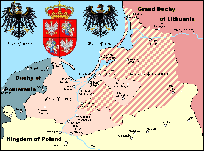
A Polish Wikipedian made version of Royal and Ducal Prussia around 1575.
Made by Halibutt in GIMP, based on an earlier GFDL map by w:User:Space Cadet and Halibutt's "Rzeczpospolita" map series.
| Kingdom of Poland | Since 1569 Polish-Lithuanian Commonwealth | |
| Grand Duchy of Lithuania | Since 1569 Polish-Lithuanian Commonwealth | |
| Royal Prussia | Pomeranian, Malbork, Chełmno Voivodships and bishopry of Warmia | |
| Ducal Prussia | Polish fief | |
| Duchy of Pomerania | Part of the Holy Roman Empire (since 1600s: "...of the German Nation") | |
| Brandenburg | Part of the Holy Roman Empire (since 1600s: "...of the German Nation") |

|
A informação textual que estava inserida na imagem foi retirada e movida para sua página de descrição ou para sua secção de metadados. Isto facilita sua utilização e compreensão em vário idiomas, além de permitir seu fácil processamento e posterior busca. O Commons desencoraja o uso de marcas d'água nas imagens para fins de identificação de autoria ou licença. Se você não deseja que sua imagem seja usada sem marca d'água, solicite que ela seja eliminada.
беларуская (тарашкевіца) | català | Deutsch | English | español | فارسی | français | galego | magyar | italiano | македонски | മലയാളം | português | русский | sicilianu | slovenščina | svenska | Indonesia | 中文 | +/− |
Licenciamento
Since the legal status of the above comment has been questioned, I hereby grant anyone the right to treat it as either a standard copyright notice, invariant section, legal statement, legal advice, friendly suggestion or a mere comment, depending on his or hers own choice. |
|

The following is a list of maps created by Halibutt and uploaded to commons, as well as their present and projected derivatives.
| Parent Image | Image | Description | |||||||||||
|---|---|---|---|---|---|---|---|---|---|---|---|---|---|
| Maps by Halibutt | |||||||||||||
| Image:Rzeczpospolita.png | Image:Rzeczpospolita.png | The Republic in 17th and 18th century | |||||||||||
| Image:Rzeczpospolita 1600.png | The Republic after the Treaty of Dywilino | ||||||||||||
| Image:Rzeczpospolita voivodships.png | Voivodships of The Republic | ||||||||||||
| Image:Rzeczpospolita_Potop.png | The Republic during The Deluge and Chmielnicki Uprising, with major battles of the era marked | ||||||||||||
| Magnates and their lands and domains | |||||||||||||
| 1st • 2nd • 3rd | Partitions of Poland | ||||||||||||
| War of the constitution | |||||||||||||
| Image:Rzeczpospolita.xcf | SOURCE FILE - GIMP format | ||||||||||||
| Image:Poland 1939.png | Image:Poland 1939.png | Poland in 1939 | |||||||||||
| Image:Dywizje wrzesien 1.png | Order of Battle on September 1st, during the Polish Defence War of 1939 | ||||||||||||
| Image:Poland 1939.xcf | SOURCE FILE - GIMP format | ||||||||||||
| Image:Polska kontur bialy.png | Image:Polska kontur bialy.png | Contour map of Poland AD 1999, for use with various locator maps | |||||||||||
| Image:Rzeczpospolita 1923.png | Image:Rzeczpospolita 1923.png | Map of Poland 1918-1939, currently under development | |||||||||||
| Image:PBW March 1919.png | Polish-Bolshevik War - fronts in March of 1919 | ||||||||||||
| Image:PBW December 1919.png | Polish-Bolshevik War - fronts in December of 1919 | ||||||||||||
| Image:PBW June 1920.png | Polish-Bolshevik War - fronts in July of 1920 | ||||||||||||
| Image:PBW August 1920.png | Polish-Bolshevik War - fronts in August of 1920 | ||||||||||||
| Polish Defence War of 1939 | |||||||||||||
| Polish areas annexed by Germany, Lithuania, Slovakia and the Soviet Union | |||||||||||||
| German concentration camps in Poland | |||||||||||||
| Curzon line | |||||||||||||
| Major battles of the Polish-Bolshevik War | |||||||||||||
| names • no names | Polish/Czechoslovak/Lithuanian/German/Ukrainian claims in 1920's | ||||||||||||
| Image:Rzeczpospolita Central Lithuania.png | Central Lithuania | ||||||||||||
| Image:Rzeczpospolita Lithuania claims.png | Central Lithuania as compared with other Lithuanian claims | ||||||||||||
| Image:Rzeczpospolita 1789-1920.png | Post-1922 borders compared with the territory of Poland before the partitions | ||||||||||||
| Warsaw Uprising and the Operation Tempest | |||||||||||||
| Poland partitioned between the Soviets and the Germans | |||||||||||||
| Image:Rzeczpospolita 1939 Polish divisions.png | Polish divisions on September 1, 1939 | ||||||||||||
| Home Army inspectorates | |||||||||||||
| Image:Rzeczpospolita 1922.xcf | SOURCE FILE - GIMP format | ||||||||||||
| Image:Rzeczpospolita 1937.svg | Vector version!!!! | layered version available on request | |||||||||||
Legendas
Elementos retratados neste ficheiro
retrata
image/png
Histórico do ficheiro
Clique uma data e hora para ver o ficheiro tal como ele se encontrava nessa altura.
| Data e hora | Miniatura | Dimensões | Utilizador | Comentário | |
|---|---|---|---|---|---|
| atual | 12h44min de 3 de abril de 2023 | | 686 × 508 (144 kB) | Natus37 | Wappenkorr. (-rote Flecke) |
| 21h30min de 19 de fevereiro de 2013 |  | 686 × 508 (127 kB) | Jbarta | remove caption, minor fix | |
| 16h27min de 28 de fevereiro de 2006 |  | 686 × 534 (141 kB) | Halibutt | A map of Royal and Ducal Prussia around 1575, made by Halibutt in GIMP, based on an [http://upload.wikimedia.org/wikipedia/en/archive/c/cb/20041019104150%21Royal_Ducal.png earlier GFDL map] by w:User:Space Cadet and Halibutt's "Rzeczpospolita" map se |
Utilização local do ficheiro
As seguintes 2 páginas usam este ficheiro:
Utilização global do ficheiro
As seguintes wikis usam este ficheiro:
- an.wikipedia.org
- ar.wikipedia.org
- ast.wikipedia.org
- az.wikipedia.org
- be.wikipedia.org
- ca.wikipedia.org
- cs.wikipedia.org
- da.wikipedia.org
- de.wikipedia.org
- el.wikipedia.org
- en.wikipedia.org
- eo.wikipedia.org
- et.wikipedia.org
- fi.wikipedia.org
- fr.wikipedia.org
- gl.wikipedia.org
- he.wikipedia.org
- hu.wikipedia.org
- id.wikipedia.org
- it.wikipedia.org
Ver mais utilizações globais deste ficheiro.
Metadados
Este ficheiro contém informação adicional, provavelmente adicionada a partir da câmara digital ou scanner utilizada para criar ou digitalizar a imagem. Caso o ficheiro tenha sido modificado a partir do seu estado original, alguns detalhes poderão não refletir completamente as mudanças efetuadas.
| Resolução horizontal | 28 pt/cm |
|---|---|
| Resolução vertical | 28 pt/cm |
| Data e hora de modificação do ficheiro | 21h29min de 19 de fevereiro de 2013 |