File:East-Hem_323bc.jpg
De Wikipedia, a enciclopédia encyclopedia
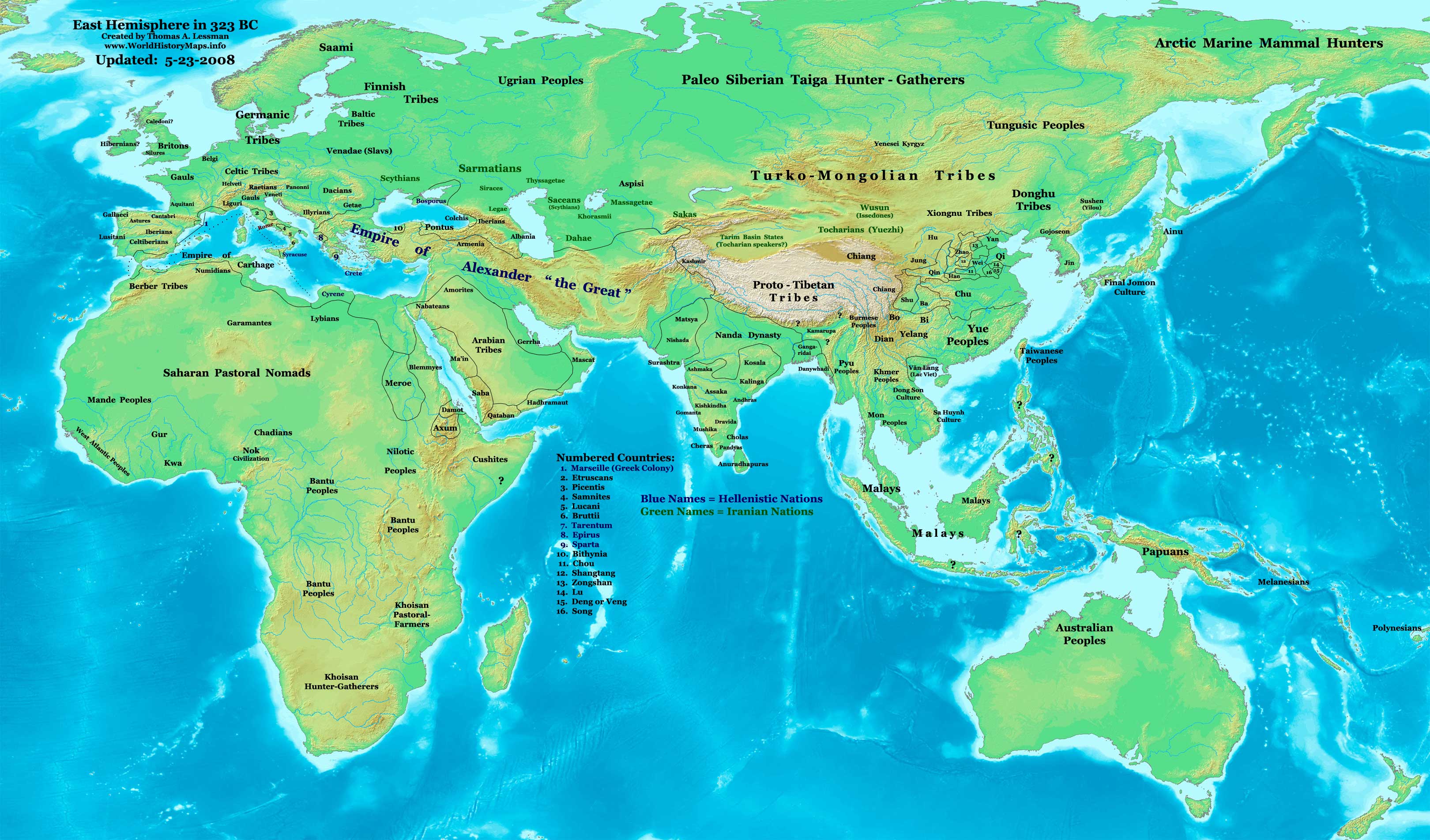
Imagem numa resolução maior (3 240 × 1 903 píxeis, tamanho: 712 kB, tipo MIME: image/jpeg)
|
|
Esta imagem provém do Wikimedia Commons, um acervo de conteúdo livre da Wikimedia Foundation que pode ser utilizado por outros projetos.
|

|
Esta imagem de historical map (ou todas as imagens neste artigo ou categoria) deveriam ser recriadas usando gráficos vectoriais, como ficheiros SVG. Isto tem várias vantagens; veja as Commons:Media for cleanup|imagens para rever para mais informações. Se já criou um ficheiro SVG desta imagem, por favor, carregue-o. Depois do novo ficheiro SVG ter sido carregado, substitua aqui esta predefinição pela predefinição {{vector version available|nome da nova imagem.svg}}.
|
 | Esta imagem foi (ou todas as imagens neste artigo ou categoria foram) carregada no formato JPEG. No entanto, contém informação que pode ser armazenada de forma mais eficiente ou precisa no formato PNG ou no formato SVG. Se possível, por favor carregue uma versão PNG ou SVG desta imagem sem artefactos de compressão, derivada de uma fonte não-JPEG ou com os artefactos de compressão removidos. Depois de o fazer:
|  |
| DescriçãoEast-Hem 323bc.jpg |
English: Eastern Hemisphere in 323 BC, at the death of Alexander the Great. |
| Origem | Obra do próprio (For reference information, see below) |
| Autor | Thomas Lessman (Contact!) |
| Permissão (Reutilizar este ficheiro) |
Eu, titular dos direitos de autor desta obra, publico-a com a seguinte licença: A utilização deste ficheiro é regulada nos termos da licença Creative Commons - Atribuição-CompartilhaIgual 3.0 Não Adaptada.
|
Índice
Map Summary
Original Source URL: http://www.thomaslessman.com/History/images/East-Hem_323bc.jpg.
This map of the Eastern Hemisphere in 323 BC was created by Thomas Lessman, based on information from the sources listed below. This map is free for educational use (see Permission info above). When using this map, please mention that it is available for free at www.WorldHistoryMaps.info.
Map Source References
- Remember, sources often conflict with each other. This map is only as accurate as the information that is available to me.
- To report any errors or to help further this work, please use the Corrections page, or email Thomas Lessman at talessman@yis.us
References for information contained in this map:
Empire of Alexander the Great information is derived from:
- The DK Atlas of World History, 2000 Edition; map of Alexander's Empire and successors; (Pg. 224)
- Wikimedia's map of The Empire of Alexander the Great uploaded by User talk:Captain Blood
- Wikipedia's article about Alexander the Great
I - European Information:
- Roman Republic borders are derived from The DK Atlas of World History, 2000 Edition; Pg. 178; Map of Italy in 240 BCE (also shows Roman borders in 300 BCE).
II - Asian Information:
- Chinese Area borders are derived from this map of The Contending States Boundries c. 350 BC, available on Huhai.net.
- Indian Kingdoms locations are derived from Wikimedia's map of Epic India.
- Gangaridai Note: the borders depicted for Gangaridai are not shown on any maps I've seen, they are described rather vaguely in the sources below:
- This article about The Origins of the Ganga Dynasty - A New Insight cópia arquivada at the Wayback Machine by Dr. Harihar Kanungo; (Pg 25, section a).
- This article from Missouri Southern State University about Gangaridae in Megasthenes' Indica cópia arquivada at the Wayback Machine; (Section 37).
- The History of Bengal website, which contains extensive information on an archeological site called Chandraketugarh, which may be the lost city of Ganga (the capital of Gangaridai).
- Nanda Dynasty borders are derived from:
- The DK Atlas of World History, 2000 Edition; Map of The Nanda and Mauryan Empires 365-181 BCE; (Pg. 241)
- Văn Lang borders are derived from:
- Wikimedia's map of Van Lang, created by User:Briangotts.
- Wikipedia's articles about Văn Lang and the Hồng Bàng Dynasty.
III - African Information and info for fringe areas like Africa, Australia, Siberia, etc. derive from:
- The DK Atlas of World History, 2000 Edition; map of The development of complex societies in Africa; (Page 160)
- Wikimedia's map of the World 323 BCE, created by User:Briangotts, and
- Wikimedia's map of the World in 300 BCE, created by User:Javierfv1212.
Note: Much of the information in this map was cross-checked with Bruce Gordon's Regnal Chronologies.
Other Maps by Thomas Lessman
| Maps of the eastern hemisphere showing history
Bold dates are available on Wikimedia or Wikipedia. | ||
| Primeval | ||
| Ancient
|
·| 600 BC | 550 BC | 527 BC | 500 BC |
400 BC | ·| 1 AD | 50 AD | 100 AD | 200 AD | 300 AD | | |
| Medieval |
·| 500 AD | 565 AD | 600 AD | 700 AD | | |
| Modern |
·| 1500 AD | · * For historical maps of the whole world, | |
| history links talk edit view | ||
Registo de carregamento original
- 2007-12-21 15:09 Talessman 3240×1903×8 (717376 bytes) Corrected info for Far eastern peoples, more info for Africa and Europe
- 2007-11-21 19:34 Talessman 3240×1903×8 (697847 bytes) Added info on lesser-known cultures. Also changed text color of Helenistic states to Blue, of Iranian peoples to green, and added names of smaller nations (numbered legend).
- 2007-11-06 22:20 Talessman 3240×1903×8 (689151 bytes) Corrected borders in Sudan (Meroe) and Arabia, added info for Japan, Indonesia, etc.
- 2007-10-02 17:49 Talessman 2880×1692×8 (546378 bytes) Author: Thomas A. Lessman. Source URL: http://www.ThomasLessman.com/History/images/East-Hem_323bc.jpg. Image was created by me (Thomas Lessman) based on historical information located on Wikipedia, as well as information from maps located in Wikipedia and
- 2007-09-12 21:35 Talessman 2880×1692×8 (514268 bytes) Author: Thomas A. Lessman. Source URL: http://www.ThomasLessman.com/History/images/East-Hem_323bc.jpg. Image was created by me (Thomas Lessman) based on historical information located on Wikipedia, as well as information from maps located in Wikipedia and
Legendas
Elementos retratados neste ficheiro
retrata
Um valor sem um elemento no repositório Wikidata
image/jpeg
Histórico do ficheiro
Clique uma data e hora para ver o ficheiro tal como ele se encontrava nessa altura.
| Data e hora | Miniatura | Dimensões | Utilizador | Comentário | |
|---|---|---|---|---|---|
| atual | 15h08min de 26 de fevereiro de 2011 | | 3 240 × 1 903 (712 kB) | Martin H. | Reverted to version as of 07:37, 23 May 2008, downscaling |
| 11h59min de 24 de fevereiro de 2011 |  | 800 × 470 (86 kB) | Prince of Nothing05 | Armenia wasn't part of Alexander the Greta's Empire | |
| 07h37min de 23 de maio de 2008 |  | 3 240 × 1 903 (712 kB) | Talessman | Corrected borders of Rome, Carthage, Alexander's Empire, Nanda Empire, and China. Also corrected placement of Tocharians, added more info for Europe, India, Africa, and East Asia. | |
| 14h53min de 9 de maio de 2008 |  | 3 240 × 1 903 (708 kB) | Talessman | {{Information |Description='''Eastern Hemisphere in 500 BC'''. |Source=self-made (For reference information, see below) |Author=Thomas Lessman (Contact!) |Permission={{self|cc-by-sa-3.0}} }} |
Utilização local do ficheiro
Não há nenhuma página que use este ficheiro.
Utilização global do ficheiro
As seguintes wikis usam este ficheiro:
- ar.wikipedia.org
- azb.wikipedia.org
- de.wikipedia.org
- el.wikipedia.org
- en.wikipedia.org
- en.wikibooks.org
- es.wikipedia.org
- fa.wikipedia.org
- it.wikipedia.org
- lv.wikipedia.org
- mk.wikipedia.org
- ru.wikipedia.org
- sh.wikipedia.org
- sl.wikipedia.org
- sq.wikipedia.org
- su.wikipedia.org
- ta.wikipedia.org
- vi.wikipedia.org
- zh.wikibooks.org