File:East-Hem_400ad.jpg
De Wikipedia, a enciclopédia encyclopedia
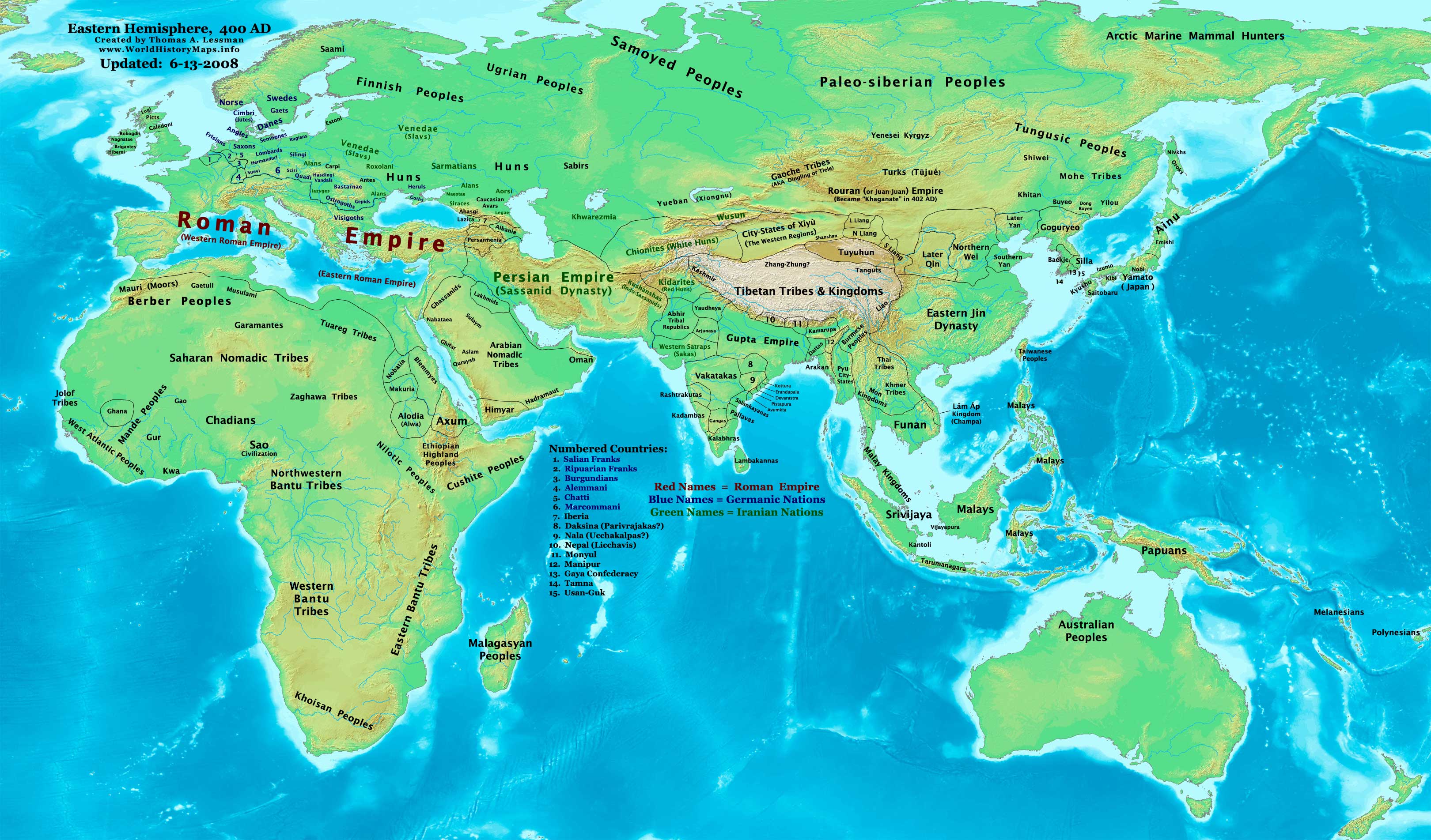
Imagem numa resolução maior (3 240 × 1 903 píxeis, tamanho: 749 kB, tipo MIME: image/jpeg)
|
|
Esta imagem provém do Wikimedia Commons, um acervo de conteúdo livre da Wikimedia Foundation que pode ser utilizado por outros projetos.
|

|
Esta imagem de historical map (ou todas as imagens neste artigo ou categoria) deveriam ser recriadas usando gráficos vectoriais, como ficheiros SVG. Isto tem várias vantagens; veja as Commons:Media for cleanup|imagens para rever para mais informações. Se já criou um ficheiro SVG desta imagem, por favor, carregue-o. Depois do novo ficheiro SVG ter sido carregado, substitua aqui esta predefinição pela predefinição {{vector version available|nome da nova imagem.svg}}.
|
 | Esta imagem foi (ou todas as imagens neste artigo ou categoria foram) carregada no formato JPEG. No entanto, contém informação que pode ser armazenada de forma mais eficiente ou precisa no formato PNG ou no formato SVG. Se possível, por favor carregue uma versão PNG ou SVG desta imagem sem artefactos de compressão, derivada de uma fonte não-JPEG ou com os artefactos de compressão removidos. Depois de o fazer:
|  |
| DescriçãoEast-Hem 400ad.jpg |
English: Eastern Hemisphere in 400 AD |
|||
| Origem | self-made (For reference information, see the Map Source References section below.) | |||
| Autor | Thomas Lessman (Contact!) | |||
| Permissão (Reutilizar este ficheiro) |
Eu, titular dos direitos de autor desta obra, publico-a com a seguinte licença: A utilização deste ficheiro é regulada nos termos da licença Creative Commons - Atribuição-CompartilhaIgual 3.0 Não Adaptada.
|
|||
| Outras versões |
|
.jpg)
Índice
Map Summary
Original Source URL: http://www.thomaslessman.com/History/images/East-Hem_400ad.jpg.
This map of the Eastern Hemisphere in 400 AD was created by Thomas Lessman, based on information from the sources listed below. This map is free for educational use (see Permission info above). When using this map, please mention that it is available for free at www.WorldHistoryMaps.info.
Map Source References
- Remember, sources often conflict with each other. This map is only as accurate as the information that is available to me. To report any errors or to help further this work, please click here, or email Thomas Lessman at talessman@yis.us
Source References for information contained in this map:
Primary Sources for East-Hem_400ad.jpg:
- 1. The DK Atlas of World History, 2000 Edition (See specific references below).
- 2. WorldHistoryMaps.com's maps of the Countries of the World, 1-1-386 cópia arquivada at the Wayback Machine.
- 3. Wikimedia's World Map 400 CE, made by User:Javierfv1212, and Wikipedia articles (noted below).
I - African Information
Note: Most of the African Information I have for 400 AD comes from The DK Atlas of World History map of The Development of Complex Societies in Africa; (Pg 160).
- (Bantus, Berber Tribes, Chadians, Cushites, Daamat, Garamantes, Gur, Khoisan Peoples, Kwa, Libyans, Mandes, Nilotic Peoples, West Atlantic Peoples)
II - Asian Information is derived from these sources:
- Arabian Tribal Locations are derived from this map of 5th century Arabia, from www.MidEastWeb.org.
- Caucasian borders are from the map of Europe in 400 AD on Euratlas.com.
- (Albania, Iberia, Lazica, and Persarmenia, etc.)
- China's Eastern Jin Dynasty borders are derived from:
- 1. The DK Atlas of World History map of The Later 16 Kingdoms period, c. 400 CE, (Pg 261)
- 2. The WorldHistoryMaps.com map of the Countries of the World, 1-1-386 cópia arquivada at the Wayback Machine.
- Funan borders are derived from:
- 1. The DK Atlas of World History, 2000 Edition; map of The World in 250 CE, (Pg 46-47).
- 2. Wikipedia's article about Funan, along with this map of Funan in 001, uploaded by User:L_joo.
- Indian Information is derived from:
- 1. Comparison of WorldHistoryMaps.com's maps of the Countries of the World in 386 cópia arquivada at the Wayback Machine and 420 CE. (Note: The 386 map is available for free on their sample page. The 420 CE map is available only to paid accounts.)
- 2. This map of Gupta Expansion[link morto], from "The World: Grand Atlas of History" by SA Ebisa, put online by the Imperial Maps cópia arquivada at the Wayback Machine website (in Spanish).
- 3. Any information missing from the maps listed above is covered in Wikipedia articles on the countries depicted.
- Japanese information is derived from the DK Atlas of World History, 2000 Edition; map of State Formation in Korea & Japan to 650 CE; (Pg 264)
- Kidarite and Kushansha borders are derived from the WorldHistoryMaps.com map of the Countries of the World in 386 CE cópia arquivada at the Wayback Machine. (Note: These maps show Kidarites as Kingdom of Gandhara and Taxila.)
- Korean and Manchurian information comes from this map of the History_of_Korea-375.png, created by User:Historiographer.
- Malay Kingdoms and peoples are derived from The DK Atlas of World History, 2000 Edition; map of "Areas influenced by India in SE Asia to 650 CE"; (Pg 241)
- Rouran or Juan-Juan information is from the History & Commercial Atlas of China, map of Asia in 440 AD, available on Huhai.net, along with Wikipedia's article about the Rouran and its first two Khagans.
- Sassanid Persian Empire borders are derived from:
- 1. Eastern Sassanid borders are based on the WorldHistoryMaps.com map of the Countries of the World in 386 CE cópia arquivada at the Wayback Machine.
- 2. Western Sassanid borders are based on the Euratlas.com map of Europe in 400 AD.
- Turks, Yueban, & Gaoche locations come from:
- 1. The History & Commercial Atlas of China, map of Asia in 440 AD, available on Huhai.net.
- 2. Wikipedia's articles about the Yueban state, the Dingling (aka Gaoche), and the Göktürks.
III - European Information is mostly derived from the Euratlas.com map of Europe in 400 AD.
IV - Australia, Siberia, & Other Fringe Information is derived from:
- 1. Wikimedia's map of the World Map 400 CE, made by User:Javierfv1212.
- 2. Comparison of The DK Atlas of World History maps of The World in 250 CE (Pg 47) and The World in 500 CE (Pg 51).
Note: Much of the information in this map was cross-checked with Bruce Gordon's Regnal Chronologies
Other Maps by Thomas Lessman
| Maps of the eastern hemisphere showing history
Bold dates are available on Wikimedia or Wikipedia. | ||
| Primeval | ||
| Ancient
|
·| 600 BC | 550 BC | 527 BC | 500 BC |
400 BC | ·| 1 AD | 50 AD | 100 AD | 200 AD | 300 AD | | |
| Medieval |
·| 500 AD | 565 AD | 600 AD | 700 AD | | |
| Modern |
·| 1500 AD | · * For historical maps of the whole world, | |
| history links talk edit view | ||
Registo de carregamento original
- 2008-02-01 23:57 Talessman 3240×1903×8 (738603 bytes) Corrected borders of North China, southeast Asia, India, added more info for Siberia and Africa.
- 2007-12-25 01:31 Talessman 3240×1903×8 (729008 bytes) Corrected borders in central Asia and India, more info for Korea, etc.
- 2007-11-21 21:34 Talessman 3240×1903×8 (718510 bytes) Reverted to version as of 01:11, 19 November 2007 (Somehow I uploaded wrong version...)
- 2007-11-21 21:34 Talessman 3240×1903×8 (718510 bytes) Reverted to version as of 01:11, 19 November 2007 (Somehow I uploaded wrong version...)
- 2007-11-19 18:53 Talessman 3240×1903×8 (718510 bytes) Corrected minor spelling errors, added info for areas that were missing from previous version.
- 2007-11-19 01:11 Talessman 3240×1903×8 (718510 bytes) Updated information on fringe peoples, fixed Jin/Pyu/Tibetan borders, fixed Makuria/Nobatia/Alodia/Blemmyes borders, fixed Arabian borders, added Nepal.
- 2007-10-30 00:11 Talessman 3240×1903×8 (695017 bytes) Added updated info for Far Eastern regions
- 2007-10-01 22:17 Talessman 2880×1692×8 (550413 bytes) Author: Thomas A. Lessman. Source URL: http://www.ThomasLessman.com/History/images/East-Hem_400ad.jpg. Image was created by me (Thomas Lessman) based on historical information located on Wikipedia, as well as information from maps located in Wikipedia and
- 2007-09-12 21:47 Talessman 2880×1692×8 (533817 bytes) Author: Thomas A. Lessman. Source URL: http://www.ThomasLessman.com/History/images/East-Hem_400ad.jpg. Image was created by me (Thomas Lessman) based on historical information located on Wikipedia, as well as information from maps located in Wikipedia and
| Anotações InfoField | Esta imagem está anotada: Ver as anotações na wiki Commons |
Western Roman Empire
Byzantine Empire
Legendas
Elementos retratados neste ficheiro
retrata
Histórico do ficheiro
Clique uma data e hora para ver o ficheiro tal como ele se encontrava nessa altura.
| Data e hora | Miniatura | Dimensões | Utilizador | Comentário | |
|---|---|---|---|---|---|
| atual | 00h02min de 14 de junho de 2008 | | 3 240 × 1 903 (749 kB) | Talessman | {{Information |Description= |Source= |Date= |Author= |Permission= |other_versions= }} |
| 00h00min de 14 de junho de 2008 |  | 3 240 × 1 903 (749 kB) | Talessman | ||
| 17h07min de 9 de maio de 2008 |  | 3 240 × 1 903 (740 kB) | Talessman | {{Information |Description=Eastern Hemisphere in 400 AD. |Source=self-made |Author=User:Talessman |Permission={{self|cc-by-sa-3.0}} }} |
Utilização local do ficheiro
Não há nenhuma página que use este ficheiro.
Utilização global do ficheiro
As seguintes wikis usam este ficheiro:
- arz.wikipedia.org
- be.wikipedia.org
- bs.wikipedia.org
- da.wikipedia.org
- en.wikipedia.org
- es.wikipedia.org
- fi.wikipedia.org
- frr.wikipedia.org
- gl.wikipedia.org
- hu.wikipedia.org
- lt.wikipedia.org
- mk.wikipedia.org
- my.wikipedia.org
- pl.wikipedia.org
- rue.wikipedia.org
- ru.wikipedia.org
- shn.wikipedia.org
- sh.wikipedia.org
- sv.wikipedia.org
- sw.wikipedia.org
- ta.wikipedia.org
- tl.wikipedia.org
- vi.wikipedia.org
Metadados
Este ficheiro contém informação adicional, provavelmente adicionada a partir da câmara digital ou scanner utilizada para criar ou digitalizar a imagem. Caso o ficheiro tenha sido modificado a partir do seu estado original, alguns detalhes poderão não refletir completamente as mudanças efetuadas.
| _error | 0 |
|---|