La Union
From Wikipedia, the free encyclopedia
La Union (Ilocano: Probinsya ti La Union; Pangasinan: Luyag na La Union; Tagalog: Probinsya ng La Union), is a province in the Philippines locatit in the Ilocos Region in the island o Luzon. Its caipital is the ceety oe San Fernando.
La Union | |
|---|---|
Province | |
 Welcome Arch of La Union at the La Union-Ilocos Sur border | |
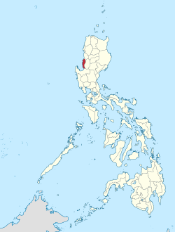
 Location in the Philippines | |
| Coordinates: 16°30′N 120°25′E | |
| Kintra | |
| Region | Region I |
| Foondit | 2 Mairch 1850 |
| Caipital | San Fernando |
| Govrenment | |
| • Govrenor | Manuel "Manoling" C. Ortega (NPC) |
| • Vice Govrenor | Aureo Nisce (NPC) |
| Area | |
| • Total | 1497.70 km2 (578.27 sq mi) |
| Area rank | 68t oot o 80 |
| Population (2010)[2] | |
| • Total | 741,906 |
| • Rank | 37t oot o 80 |
| • Density | 500/km2 (1,300/sq mi) |
| • Density rank | 10t oot o 80 |
| Diveesions | |
| • Independent ceeties | 0 |
| • Component ceeties | 1 |
| • Municipalities | 19 |
| • Barangays | 576 |
| • Districts | 1st and 2nd districts of La Union |
| Time zone | UTC+8 (PHT) |
| ZIP code | 2500 – 2520 |
| Dialin code | 72 |
| Leids | Ilokano, Pangasinan, Kankanaey, Ibaloi, Tagalog, Inglis |
| Website | launion.gov.ph |
The province is bordered bi Ilocos Sur tae the north, Benguet tae the east, Pangasinan tae the sooth, an tae the wast bi the shores o the Sooth Cheenae Sea.
References
Freemit airtins
Wikiwand in your browser!
Seamless Wikipedia browsing. On steroids.
Every time you click a link to Wikipedia, Wiktionary or Wikiquote in your browser's search results, it will show the modern Wikiwand interface.
Wikiwand extension is a five stars, simple, with minimum permission required to keep your browsing private, safe and transparent.


