Agout
tributary of the Tarn in France From Wikipedia, the free encyclopedia

Remove ads
The Agout or Agoût (Occitan: Agot) is a river in southwestern France, left tributary of the Tarn river. It flows through the Occitanie region.

Three communes have the name of the river in their names: La Salvetat-sur-Agout, Fraisse-sur-Agout and Vielmur-sur-Agout.
Remove ads
Geography
The Agout river has a length of 194.4 km (120.8 mi) and a drainage basin with an area of 3,497 km2 (1,350 sq mi).[1]
Its average yearly discharge (volume of water which passes through a section of the river per unit of time) is 41 m3/s (1,400 cu ft/s) at Lavaur in the Tarn department.[2]

Average monthly discharge (m3/s) at Lavaur (56 years)[2]
Course
The source of the Agout is on the Monts d'Espinouse, in the southern Massif Central in the Parc Naturel Régional du Haut-Languedoc ("Regional Natural Park of High Languedoc"), in the commune of Cambon-et-Salvergues, Hérault department, at an altitude of about 1,060 m (3,478 ft).[3]
The Agout flows, in general, to the northwest and passes through the following regions, departments and communes:
- Occitanie region
- Hérault: La Salvetat-sur-Agout, Fraisse-sur-Agout
- Tarn: Brassac, Castelnau-de-Brassac, Coufouleux, Giroussens, Burlats, Lavaur, Castres, Rabastens, Saint-Sulpice
The Agout river flows through a total of 36 communes.[1]
Finally, it flows, as a left tributary into the Tarn river at Saint-Sulpice, in the Tarn department, at 98 m (322 ft) of altitude.[4]
Remove ads
Main tributaries
The main tributaries, with a length greater than 30 km, of the Agout are:
Gallery
 Cambon-et-Salvergues: Source of the river Agout
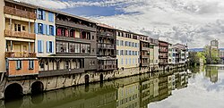 Houses in Castres by the Agout river
 The Agout at Giroussens
 The Agout at Castres
 Bridge over the Agout at Brassac

_Maisons_sur_l'Agoût_vues_du_pont_Neuf_vers_le_pont_Henri_Sizaire.jpg)


_-_La_chaussée_du_moulin_sur_l'Agout.jpg)
Related pages
References
Other websites
Wikiwand - on
Seamless Wikipedia browsing. On steroids.
Remove ads