Arunachal Pradesh
region administered by India as a state From Wikipedia, the free encyclopedia

Remove ads
Arunachal Pradesh is a state in India bordered with China. The country that owns this region is disputed. China says that they own it and call it South Tibet[2] (Zangnan 藏南). In 2017, China started renaming places in this territory.[2] In 2019 China destroyed 30,000 "incorrect" world maps that showed South Tibet as part of India.[3][4]

Remove ads
History
The territory's northern boundary is about 550 miles long. It is known as the McMahon Line.
It is part of the border dispute between India and China. There is another dispute to the northwest in Aksai Chin (also with Pakistan).
In 1962, the Sino-Indian War was fought here. The war was short and ended in India's defeat. However, China withdrew back to the modern borders voluntarily. They still say that they own the region.
Remove ads
Who lives there?
The people share cultural similarities with their neighbors in Tibet and the Myanmar's hill region.
As of 2001, there were 1,091,117 people living in Arunachal Pradesh. The total area is 32,333 mi² (83,743 km²).
Most people speak Sino-Tibetan languages like Nyishi and Adi (over 50%). The rest speak Indo-Aryan languages like Nepali, Bengali, and Hindi.
State symbols of Arunachal Pradesh
 Provincial bird
 Provincial animal
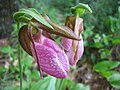 Provincial flower

.png)

Related pages
References
Wikiwand - on
Seamless Wikipedia browsing. On steroids.
Remove ads