Clain
river in France From Wikipedia, the free encyclopedia

Remove ads
The Clain is a river in western France that flows through the Nouvelle-Aquitaine region. It flows into the Vienne river, as a left tributary.
.png)
Remove ads
Geography
The Clain river has a length of 144 km (89 mi) and a drainage basin with an area of approximately 3,217 km2 (1,242 sq mi).[1]
Its average yearly discharge (volume of water which passes through a section of the river per unit of time) is 21.5 m3/s (760 cu ft/s) at Dissay, south of Châtellerault near the confluence with the Vienne river.[2]

Average monthly discharge (m3/s) at Dissay
Course
The Clain river starts in the Charente department near the border with the Vienne department, in the place called Chapelle Beau Clain to the south of the commune of Hiesse, at an elevation of about 210 m (689 ft).[3] From here, it flows to the north into the Vienne department.
Finally, the river flows into the Vienne river, on the left side, in the commune of Cenon-sur-Vienne near Châtellerault.[4]
The Clain flows through 2 departments and 33 communes, in the Nouvelle-Aquitaine region:[1]
- Charente: Hiesse, Alloue.
- Vienne: Champagne-Saint-Hilaire, Pressac, Epenede, Romagne, Sommières-du-Clain, Château-Garnier, Joussé, Payroux, Mauprevoir, Saint-Martin-l'Ars, Voulon, Anche, Naintré, Beaumont, Vouneuil-sur-Vienne, Saint-Cyr, Migne-Auxances, Jaunay-Clan, Chasseneuil-du-Poitou, Saint-Georges-lès-Baillargeaux, Dissay, Liguge, Poitiers, Saint-Benoit, Buxerolles, Smarves, Iteuil, Roches-Premarie-Andille, Aslonnes, Vivonne, Cenon-sur-Vienne (confluence).
Remove ads
Main tributaries
The main tributaries of the Clain river are:[1]
|
Left tributaries:
|
Right tributaries:
|
Gallery
 The Clain in the Pont Saint-Cyprien, Poitiers.
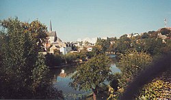 The Clain in Poitiers.
 The Clain in Chasseneuil-du-Poitou.
 Pont de la Millière over the Clain, Romagne.


Related pages
References
Other websites
Wikiwand - on
Seamless Wikipedia browsing. On steroids.
Remove ads