Encamp
parish of Andorra From Wikipedia, the free encyclopedia

Remove ads
Encamp is one of the seven parishes of Andorra. It is in the east central part of the country. Encamp is also the name of the main town of the parish.


Remove ads
Geography
The Encamp parish is in the east central part of the country and borders with the Canillo parish to the north, with the Pyrénées-Orientales department (France) to the east, with Spain to the southeast, with the Escaldes-Engordany parish to the south, with the La Massana parish to the west and the Ordino parish to the northwest.
The highest mountain in the parish is Pic del Pessons (42°30′30″N 1°39′32″E) with an elevation of 2,840 m (9,320 ft) above sea level.[4]
The main river in Encamp is the Valira d'Orient.
Remove ads
Population
The parish had a population, in 2015, of 12,212 inhabitants,[3] for a population density of 142.0 persons/km².
Evolution of the population in Encamp[5]

| 1981 | 1986 | 1991 | 1996 | 2001 | 2006 | 2011 | 2015 |
|---|---|---|---|---|---|---|---|
| 4,231 | 5,766 | 8,680 | 9,800 | 10,627 | 13,685 | 13,521 | 12,212 |
Villages
The urban areas in the parish are:
Economy
The main economic activity is tourism and the parish is a major tourism destination.
Sites of interest
- Sant Romà de Vila church in Vila
- Sant Romà de les Bons church in Les Bons
- Museu Nacional de l’Automòbil d’Andorra, a automobile museum in Encamp
- Santa Eulàlia d'Encamp church in Encamp
- Grandvalira ski resort
Gallery
 Encamp town hall
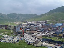 El Pas de la Casa
 Sant Romà de Vila church
 Sant Romà de les Bons church


References
Wikiwand - on
Seamless Wikipedia browsing. On steroids.
Remove ads