Haute-Saône
French department From Wikipedia, the free encyclopedia

Remove ads
Haute-Saône is a department in the east of France. It is in the Bourgogne-Franche-Comté region. It is named after the Saône river and its capital (prefecture) is the city of Vesoul.


Remove ads
History
Haute-Saône is one of the original 83 departments created during the French Revolution on 4 March 1790.[4] It was formed from part of the old province of Franche-Comté.
It was divided in six districts: Jussey, Luxeuil, Lure, Vesoul, Gray and Champlitte with the capital in Gray alternating with Vesoul. In 1794, only Gray remained as the capital.[4]
In 1800, with the creation of the arrondissements in France, the six districts were changed into three arrondissements: Vesoul, Gray and Lure; the capital was moved from Gray to Vesoul.[4]
After the Battle of Waterloo (18 June 1815), the department was occupied by the Austrian army from June 1815 to November 1818.
On 10 September 1926, the arrondissement of Gray was eliminated.[4]
Remove ads
Geography
Haute-Saône is part of the Bourgogne-Franche-Comté region. It has an area of 5,360.1 km2 (2,070 sq mi).[2]
The department borders with 6 other departments in two regions:
- Bourgogne-Franche-Comté region
- Côte-d'Or (southwest)
- Doubs (east)
- Jura (south)
- Territoire de Belfort (east)
- Grand Est region
- Haute-Marne (west)
- Vosges (north)
The main river in the department is the Saône, that flows through the department from northeast to southwest. The highest mountain in the department is Ballon de Servance (47°49′48″N 6°47′35″E), 1,216 m (3,990 ft) high;[5] it is in the commune Servance-Miellin.
Climate
The Köppen climate classification type for the climate at Lure is an "Oceanic climate" (also known as Maritime Temperate climate) and of the subtype Cfb.[6]
The average temperature for the year in Lure is 9.4 °C (48.9 °F). The warmest month, on average, is July with an average temperature of 17.2 °C (63.0 °F). The coolest month, on average is January, with an average temperature of 0.6 °C (33.1 °F).
The average amount of precipitation (rainfall) for the year in Lure is 744.2 mm (29.30 in). The month with the most precipitation on average is August with 88.9 mm (3.50 in) of precipitation. The month with the least precipitation on average is March with an average of 43.2 mm (1.70 in).[6]
Remove ads
Administration
Haute-Saône is managed by the Departmental Council of Haute-Saône in Vesoul. The department is part of the Bourgogne-Franche-Comté region.
Administrative divisions
There are 2 arrondissements (districts), 17 cantons and 542 communes (municipalities) in Haute-Saône.[7]
The following is a list of the 17 cantons of the Haute-Saône department (with their INSEE codes), following the French canton reorganisation which came into effect in March 2015:[10]
- Dampierre-sur-Salon (7001)
- Gray (7002)
- Héricourt-1 (7003)
- Héricourt-2 (7004)
- Jussey (7005)
- Lure-1 (7006)
- Lure-2 (7007)
- Luxeuil-les-Bains (7008)
- Marnay (7009)
- Mélisey (7010)
- Port-sur-Saône (7011)
- Rioz (7012)
- Saint-Loup-sur-Semouse (7013)
- Scey-sur-Saône-et-Saint-Albin (7014)
- Vesoul-1 (7015)
- Vesoul-2 (7016)
- Villersexel (7017)
Demographics
The inhabitants of Haute-Saône are known, in French, as Haut-Saônois (women: Haut-Saônoises).[11]
Haute-Saône had a population, in 2014, of 238,347,[3] for a population density of 44.5 inhabitants/km2. The arrondissement of Vesoul, with 129,622 inhabitants, is the arrondissement with more inhabitants.[8]
Evolution of the population in Haute-Saône

The cities with more than inhabitants in the department are:[8]
Remove ads
Gallery


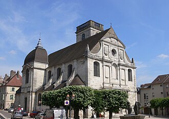 Saint-Georges church, Vesoul.
 Château de Champlitte.
 The Saône river in Gray.
 Castle of Villersexel.


References
Related pages
Other websites
Wikiwand - on
Seamless Wikipedia browsing. On steroids.
Remove ads