Lesser Poland Voivodeship
voivodeship of Poland From Wikipedia, the free encyclopedia
Remove ads
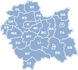
Lesser Poland Voivodeship, or Małopolska Province,[1] is a voivodeship, or province, in southern Poland. It is 15,108 square kilometres (5,833 sq mi), and as of 2006, has 3,267,731 residents. It was created on 1 January 1999. The capital of the province is Kraków.
The province's natural borders are Świętokrzyskie Mountains (Góry Świętokrzyskie) on the north, Jura Krakowsko-Częstochowska (a broad range of hills stretching from Kraków to Częstochowa) on the west, and the Tatra, Pieniny and Beskidy Mountains on the south. The provinces and countries it is bordered by are the Silesian Voivodeship to the west, Świętokrzyskie Voivodeship to the north, Subcarpathian Voivodeship to the east, and the country of Slovakia to the south.
Remove ads
Protected areas


Protected areas in Lesser Poland Voivodeship include six National Parks and 11 Landscape Parks. These are listed below.
- Babia Góra National Park (a UNESCO-designated biosphere reserve)
- Gorce National Park
- Magura National Park (partly in Subcarpathian Voivodeship)
- Ojców National Park
- Pieniny National Park
- Tatra National Park (part of a UNESCO biosphere reserve shared with Slovakia)
- Bielany-Tyniec Landscape Park
- Ciężkowice-Rożnów Landscape Park
- Dłubnia Landscape Park
- Eagle Nests Landscape Park (partly in Silesian Voivodeship)
- Kraków Valleys Landscape Park
- Little Beskids Landscape Park (partly in Silesian Voivodeship)
- Pasmo Brzanki Landscape Park (partly in Subcarpathian Voivodeship)
- Poprad Landscape Park
- Rudno Landscape Park
- Tenczynek Landscape Park
- Wiśnicz-Lipnica Landscape Park
Remove ads
References
Other websites
Wikiwand - on
Seamless Wikipedia browsing. On steroids.
Remove ads


