County
|
FIPS code[2]
|
County seat[3]
|
Created[3]
|
Formed from
|
Meaning of name |
Population[4] |
Area[3] |
Map |
| Aurora County |
003 |
Plankinton | 1881 | Cragin and Wetmore counties | Aurora, Roman goddess of dawn |
2,747 |
708 sq mi
(1,834 km2) |  |
| Beadle County |
005 |
Huron | 1879 | Buchard, Clark, Kingsbury, and Spink counties | William Henry Harrison Beadle, chief surveyor of Dakota Territory |
19,149 |
1,259 sq mi
(3,261 km2) |  |
| Bennett County |
007 |
Martin | 1909 | Lugenbeel, Oglala Lakota, Washabaugh, and Washington counties | Granville G. Bennett, justice of the Supreme Court for the Dakota Territory |
3,381 |
1,185 sq mi
(3,069 km2) | 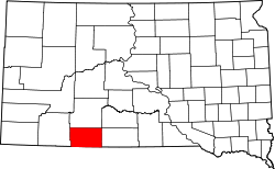 |
| Bon Homme County |
009 |
Tyndall | 1862 | Unorganized territory | French phrase meaning "good man" |
7,003 |
563 sq mi
(1,458 km2) |  |
| Brookings County |
011 |
Brookings | 1862 | Unorganized territory | Wilmot Brookings (1830 - 1905), Dakota Territory Supreme Court justice |
34,375 |
794 sq mi
(2,056 km2) |  |
| Brown County |
013 |
Aberdeen | 1879 | Beadle County | Alfred Brown, territorial legislator |
38,301 |
1,713 sq mi
(4,437 km2) |  |
| Brule County |
015 |
Chamberlain | 1875 | Charles Mix County | Brulé Sioux Native Americans |
5,247 |
819 sq mi
(2,121 km2) |  |
| Buffalo County |
017 |
Gann Valley | 1873 | Unorganized territory | American Bison |
1,948 |
471 sq mi
(1,220 km2) | 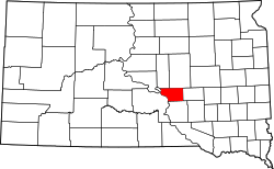 |
| Butte County |
019 |
Belle Fourche | 1883 | Harding | Buttes in the region |
10,243 |
2,249 sq mi
(5,825 km2) |  |
| Campbell County |
021 |
Mound City | 1873 | Buffalo | Norman B. Campbell, territorial legislator |
1,377 |
736 sq mi
(1,906 km2) |  |
| Charles Mix County |
023 |
Lake Andes | 1862 | Unorganized territory | Charles Eli Mix, commissioner of Indian Affairs |
9,373 |
1,098 sq mi
(2,844 km2) | 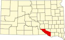 |
| Clark County |
025 |
Clark | 1873 | Hanson | Newton Clark, territorial legislator |
3,837 |
958 sq mi
(2,481 km2) | 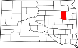 |
| Clay County |
027 |
Vermillion | 1862 | Unorganized territory | Henry Clay (1777 - 1852), U.S. Senator from Kentucky and prominent 19th Century political figure |
14,967 |
412 sq mi
(1,067 km2) |  |
| Codington County |
029 |
Watertown | 1877 | Indian lands | Reverend G.S. Codington, territorial legislator |
28,325 |
688 sq mi
(1,782 km2) | 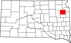 |
| Corson County |
031 |
McIntosh | 1909 | Indian lands | Dighton Corson, a Justice of the South Dakota Supreme Court |
3,902 |
2,473 sq mi
(6,405 km2) |  |
| Custer County |
033 |
Custer | 1875 | Indian lands | General George Armstrong Custer (1839 - 1876), key figure in the Indian Wars |
8,318 |
1,558 sq mi
(4,035 km2) |  |
| Davison County |
035 |
Mitchell | 1873 | Hanson | Henry C. Davison, prominent merchant and early settler |
19,956 |
436 sq mi
(1,129 km2) |  |
| Day County |
037 |
Webster | 1879 | Clark | Merrit H. Day, territorial legislator |
5,449 |
1,029 sq mi
(2,665 km2) |  |
| Deuel County |
039 |
Clear Lake | 1862 | Brookings | Jacob S. Deuel, territorial legislator |
4,295 |
624 sq mi
(1,616 km2) |  |
| Dewey County |
041 |
Timber Lake | 1873 | Armstrong County and Indian lands | William P. Dewey, territorial surveyor-general |
5,239 |
2,303 sq mi
(5,965 km2) | 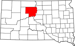 |
| Douglas County |
043 |
Armour | 1873 | Charles Mix | Stephen A. Douglas (1813 - 1861), U.S. Senator from Illinois and advocate of popular sovereignty as a middle ground in the slavery debate |
2,835 |
434 sq mi
(1,124 km2) | 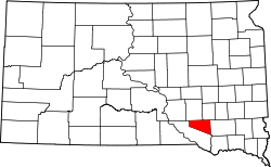 |
| Edmunds County |
045 |
Ipswich | 1873 | Buffalo | Newton Edmunds, Governor of Dakota Territory |
3,986 |
1,146 sq mi
(2,968 km2) |  |
| Fall River County |
047 |
Hot Springs | 1883 | Custer | Fall River |
6,973 |
1,740 sq mi
(4,507 km2) |  |
| Faulk County |
049 |
Faulkton | 1873 | Unorganized lands | Andrew Jackson Faulk, Governor of Dakota Territory |
2,125 |
1,000 sq mi
(2,590 km2) | 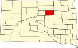 |
| Grant County |
051 |
Milbank | 1873 | Codington and Deuel counties | Ulysses S. Grant (1822 - 1885), U.S. President and American Civil War general |
7,556 |
682 sq mi
(1,766 km2) |  |
| Gregory County |
053 |
Burke | 1862 | Unorganized territory | John Shaw Gregory, territorial legislator |
3,994 |
1,016 sq mi
(2,631 km2) |  |
| Haakon County |
055 |
Philip | 1914 | Stanley County | King Haakon VII of Norway |
1,872 |
1,813 sq mi
(4,696 km2) | 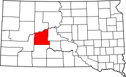 |
| Hamlin County |
057 |
Hayti | 1873 | Deuel County | Hannibal Hamlin, Vice-President and United States Senator from Maine |
6,164 |
511 sq mi
(1,323 km2) |  |
| Hand County |
059 |
Miller | 1873 | Buffalo County | George H. Hand, territorial legislator |
3,145 |
1,437 sq mi
(3,722 km2) |  |
| Hanson County |
061 |
Alexandria | 1873 | Buffalo and Deuel counties | Joseph R. Hanson, army major in the Indian Wars and early settler |
3,461 |
435 sq mi
(1,127 km2) |  |
| Harding County |
063 |
Buffalo | 1909 | Unorganized lands | J.A. Harding, Speaker of the House for Dakota Territory |
1,311 |
2,671 sq mi
(6,918 km2) | 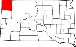 |
| Hughes County |
065 |
Pierre | 1880 | Buffalo County | Alexander Hughes, territorial legislator |
17,765 |
741 sq mi
(1,919 km2) | 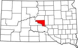 |
| Hutchinson County |
067 |
Olivet | 1862 | Unorganized territory | John Hutchinson, territorial legislator |
7,427 |
813 sq mi
(2,106 km2) |  |
| Hyde County |
069 |
Highmore | 1873 | Buffalo County | James Hyde, territorial legislator |
1,262 |
861 sq mi
(2,230 km2) |  |
| Jackson County |
071 |
Kadoka | 1914 | Stanley County | J.R. Jackson, territorial legislator |
2,806 |
1,869 sq mi
(4,841 km2) |  |
| Jerauld County |
073 |
Wessington Springs | 1883 | Aurora County | H.A. Jerauld, territorial legislator |
1,663 |
530 sq mi
(1,373 km2) |  |
| Jones County |
075 |
Murdo | 1916 | Lyman County | George W. Jones, territorial legislator |
917 |
971 sq mi
(2,515 km2) |  |
| Kingsbury County |
077 |
De Smet | 1873 | Hanson County | George W. Kingsbury and T.A. Kingsbury, brothers and territorial legislators |
5,187 |
838 sq mi
(2,170 km2) |  |
| Lake County |
079 |
Madison | 1873 | Brookings and Hanson counties | Lakes within the county |
11,059 |
563 sq mi
(1,458 km2) |  |
| Lawrence County |
081 |
Deadwood | 1875 | Unorganized territory | John Lawrence (1839 - 1889), territorial legislator |
25,768 |
800 sq mi
(2,072 km2) |  |
| Lincoln County |
083 |
Canton | 1867 | Unorganized territory | Abraham Lincoln, the 16th President of the United States,[5] or, possibly, Lincoln County, Maine. |
65,161 |
578 sq mi
(1,497 km2) | 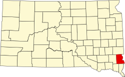 |
| Lyman County |
085 |
Kennebec | 1873 | Unorganized territory | W.P. Lyman, territorial legislator |
3,718 |
1,640 sq mi
(4,248 km2) |  |
| Marshall County |
091 |
Britton | 1885 | Day County | Marshall Vincent, Day County Commissioner |
4,306 |
839 sq mi
(2,173 km2) |  |
| McCook County |
087 |
Salem | 1873 | Hanson County | Edwin McCook, Secretary of Dakota Territory |
5,682 |
575 sq mi
(1,489 km2) |  |
| McPherson County |
089 |
Leola | 1873 | Buffalo County | James B. McPherson (1828 - 1864), Civil War general |
2,411 |
1,137 sq mi
(2,945 km2) |  |
| Meade County |
093 |
Sturgis | 1889 | Lawrence County | George Meade (1815 - 1872), Civil War general |
29,852 |
3,471 sq mi
(8,990 km2) |  |
| Mellette County |
095 |
White River | 1909 | Lyman County | Arthur C. Mellette, first Governor of South Dakota |
1,918 |
1,307 sq mi
(3,385 km2) | 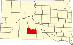 |
| Miner County |
097 |
Howard | 1873 | Hanson County | Nelson Miner and Ephriam Miner, brothers and territorial legislators |
2,298 |
570 sq mi
(1,476 km2) |  |
| Minnehaha County |
099 |
Sioux Falls | 1862 | Unorganized territory | Sioux term for waterfall |
197,214 |
809 sq mi
(2,095 km2) | 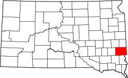 |
| Moody County |
101 |
Flandreau | 1873 | Brookings and Minnehaha counties | Gideon C. Moody, Speaker of the House for Dakota Territory |
6,336 |
520 sq mi
(1,347 km2) |  |
| Oglala Lakota County |
102 |
| 1875 | Fall River County | Oglala Lakota tribe |
13,672 |
2,094 sq mi
(5,423 km2) |  |
| Pennington County |
103 |
Rapid City | 1875 | Unorganized territory | John L. Pennington (1829 - 1900), Governor of Dakota Territory |
109,222 |
2,776 sq mi
(7,190 km2) |  |
| Perkins County |
105 |
Bison | 1909 | Butte and Harding counties | Henry E. Perkins, state senator |
2,835 |
2,872 sq mi
(7,438 km2) |  |
| Potter County |
107 |
Gettysburg | 1875 | Buffalo County | Joel A. Potter, territorial legislator |
2,472 |
866 sq mi
(2,243 km2) |  |
| Roberts County |
109 |
Sisseton | 1883 | Grant County | S.G. Roberts, territorial legislator |
10,280 |
1,101 sq mi
(2,852 km2) | 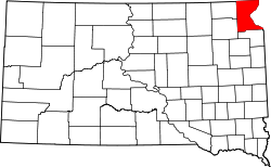 |
| Sanborn County |
111 |
Woonsocket | 1883 | Miner County | George W. Sanborn, president of the Milwaukee Railroad |
2,330 |
569 sq mi
(1,474 km2) |  |
| Spink County |
115 |
Redfield | 1873 | Hanson County | Solomon Spink, Secretary of Dakota Territory |
6,361 |
1,504 sq mi
(3,895 km2) |  |
| Stanley County |
117 |
Fort Pierre | 1873 | Unorganized territory | David S. Stanley, commander of Fort Sully |
2,980 |
1,443 sq mi
(3,737 km2) |  |
| Sully County |
119 |
Onida | 1873 | Potter County | Fort Sully, itself named after General Alfred Sully |
1,446 |
1,007 sq mi
(2,608 km2) |  |
| Todd County |
121 |
| 1909 | Meyer and Tripp counties | John Blair Smith Todd, territorial delegate to Congress |
9,319 |
1,388 sq mi
(3,595 km2) |  |
| Tripp County |
123 |
Winner | 1873 | Unorganized territory | Bartlett Tripp, Chief Justice of the Dakota Territorial Supreme Court |
5,624 |
1,614 sq mi
(4,180 km2) |  |
| Turner County |
125 |
Parker | 1871 | Lincoln County | John W. Turner, territorial legislator |
8,673 |
617 sq mi
(1,598 km2) |  |
| Union County |
127 |
Elk Point | 1862 | Unorganized territory | The union of the American states |
16,811 |
460 sq mi
(1,191 km2) | 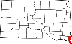 |
| Walworth County |
129 |
Selby | 1873 | Buffalo County | Walworth County, Wisconsin |
5,315 |
708 sq mi
(1,834 km2) |  |
| Yankton County |
135 |
Yankton | 1862 | Unorganized territory | Yankton Sioux Native Americans |
23,310 |
522 sq mi
(1,352 km2) |  |
| Ziebach County |
137 |
Dupree | 1911 | Armstrong, Schnasse, and Sterling counties | Frank M. Ziebach, publisher and army major during the Indian Wars |
2,413 |
1,962 sq mi
(5,082 km2) |  |


