Northern Dobruja
historical region in Romania From Wikipedia, the free encyclopedia
Remove ads
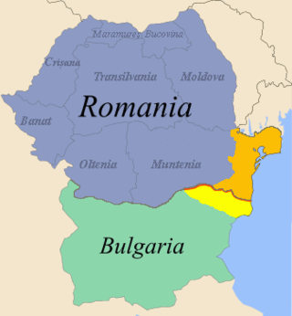
Northern Dobruja (Romanian: Dobrogea de Nord or simply Dobrogea; Bulgarian: Северна Добруджа, Severna Dobrudzha) is the part of Dobruja that is in Romania. It is between the lower Danube river and the Black Sea. To the south is Southern Dobruja, the Bulgarian part of Dobruja.

Geography
The territory of Northern Dobruja now forms the counties of Constanța and Tulcea. It has a total area of 15,570 km2 and a population of slightly under 900,000.[1]
Cities
Rivers
- Casimcea
- Slava
- Taița
- Telița
Lakes
- Crapina Lake
- Jijiei Lake
- Traian Lake
- Babadag Lake
- Razim Lake
- Zmeica Lake
- Sinoe Lake
- Tașaul Lake
- Techirghiol Lake
Danube Delta
The Danube Delta is made of many lakes. The most important ones are:
- Roșu
- Isac
- Gorgova
- Furtuna
- Ledeanca
- Tatanir
- Merhel
- Matița
- Uzlina
- Dranov
- Lumina
- Puiu
- Puiuleț
Remove ads
Demographics
Ethnic composition
The table below shows Romanian statistics throughout the years:
- 1According to the 1926–1938 Romanian administrative division (counties of Constanța and Tulcea), which excluded a part of today's Romania (chiefly the communes of Ostrov and Lipnița, now part of Constanța County) and included a part of today's Bulgaria (parts of General Toshevo and Krushari municipalities)
- 2Only Russians. (Russians and Lipovans counted separately)
Remove ads
Symbols

Northern Dobruja is represented by two dolphins in the coat of arms of Romania.
Starting with 2015, Romania observes Dobruja Day on November 14. This day is the day in 1878 when Northern Dobruja became part of the Kingdom of Romania after the Treaty of Berlin.[8]
References
Wikiwand - on
Seamless Wikipedia browsing. On steroids.
Remove ads
