Petrus Plancius
Dutch-Flemish astronomer, cartographer and clergyman From Wikipedia, the free encyclopedia

Remove ads
Petrus Plancius (1552 – May 15, 1622) was a Flemish astronomer, cartographer and clergyman. He was born as Pieter Platevoet in Dranouter, now in Heuvelland, West Flanders. He studied theology in Germany and England. At the age of 24 he became a minister in the Dutch Reformed Church.
Cartography

In 1592 he published his best known world map named "Nova et exacta Terrarum Tabula geographica et hydrographica".[1] He wrote journals and shipping maps. He made a new way for finding longitude. He was the first to use the Mercator projection for navigational maps.
He was one of the founders of the Dutch East India Company. He drew over 100 maps.
Plancius knew Henry Hudson. Hudson was an explorer of the New World.
Plancius made the map, Exacta & accurata delinatio… regionibus China, Cauchinchina, Camboja, sive Champa, Syao, Malacca, Arracan & Pegu, that was in Jan Huygen van Linschoten’s popular book, Itinerario (1596).[2]
Maps
 Orbis Terrarum 1590
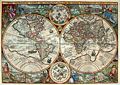 Orbis Terrarum 1594
 Nova Francia .. Terra Nova 1592
 Insulae Moluccae 1592


Remove ads
References
Other websites
Wikiwand - on
Seamless Wikipedia browsing. On steroids.
Remove ads