Saba
island in the Caribbean, part of the Netherlands From Wikipedia, the free encyclopedia

Remove ads
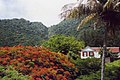
Saba (spoken as "Sah-ba") is the smallest island of the Caribbean Netherlands and the former Netherlands Antilles. It is a special municipality (public body) of the Netherlands. It lies at 17°38′N 63°14′W. It is mostly made up of Mount Scenery (877 m), the highest point of the Kingdom of the Netherlands. Scenery is a dormant volcano.


Saba has a land area of 13 km² (5 sq. miles). At the 2001 Netherlands Antilles census, 1,349 people lived there. In 2004, about 1,424 people lived there.
Remove ads
Gallery
 Hawksbill Turtle
 Saba's airport


Notes
References
Other websites
Wikiwand - on
Seamless Wikipedia browsing. On steroids.
Remove ads